Contents
Message From the FGDC Staff Director
FGDC Executive of the Year Secretary Dirk Kempthorne
Geospatial Data Meets the Wildfire Challenge
FGDC: Leading Development of Integrated Geospatial Capabilities
FGDC Goals for Fiscal Year 2009
Appendix A. FGDC Leadership Profiles
Appendix B. FGDC Structure and Membership
Status of NSDI Framework Data Themes
Appendix D. Glossary of Abbreviations and Terms

This image simulates fire spread
in the Middle Fork Payette River region of the Boise National Forest.
As can be seen, the modeled fire spread is nonlinear, with the
probabilities dropping dramatically as the fire spreads across the
lowland regions.
Fire spread probability information can be valuable for helping to
reduce loss of life and property.
I am pleased to announce the release of the Federal Geographic Data Committee’s (FGDC) 2008 Annual Report, which highlights some of the year’s exciting activities across the geospatial landscape. The theme for this year’s report is how geospatial data provide critical support for wildfire response.
In 2008, we were engaged in some very significant developments. We established and conducted the initial meetings of the National Geospatial Advisory Committee (NGAC), a Federal advisory committee whose membership includes representatives from 28 Government and nongovernmental organizations (see Appendix B). The NGAC holds public forums to discuss geospatial activities and solicits input from State, Tribal, regional, and local governments, academic institutions, and the private sector. At its inaugural meeting in April 2008, I asked the NGAC to provide advice on FGDC priority areas, including advancing the National Spatial Data Infrastructure (NSDI), public-private partnerships, and OMB Circular A–16. I also asked for an evaluation and recommendations on key data initiatives such as Imagery for the Nation (IFTN), The National Map, the National Land Parcel Study, and the National Land Imaging Program. Several important issues were raised and actions were assigned to subcommittees for further analysis. Their results were brought back to the full committee for consideration.
The FGDC Executive Committee also met for the first time in April. The committee is comprised of senior agency officials and represents agencies that conduct significant geospatial activities in support of their mission. In 2008, the Executive Committee provided guidance and expedited some of the more challenging decisions placed before the FGDC Steering Committee. This resulted in a more collaborative and effective model for addressing geospatially related activities.
Secretary of the Interior Dirk Kempthorne is profiled in this Annual Report as the “Executive of the Year” for his vision, innovation, and outstanding achievements on behalf of the geospatial community. He was recognized and honored for his efforts with an industry award. Secretary Kempthorne’s numerous accomplishments are highlighted in this report and are a tribute to his leadership.
Together, we have come a long way in positioning the geospatial community for the upcoming transition to a new Administration. Fiscal year 2009 will focus on continued strong leadership, effective coordination and analysis of business practices to enable better public-private partnerships and investments, and continued progress on the important issues designated by agencies and the public we serve.
I have thoroughly enjoyed working with the FGDC and the geospatial community, and I thank all of you who have contributed to its successes.
Sincerely yours,
James E.
Cason, U.S. Department of the Interior
Chair, FGDC Steering Committee
![]()
Message From the FGDC Staff Director
On behalf of the FGDC member organizations and the broader geospatial community, I thank James E. Cason, FGDC Chair, and Karen S. Evans, FGDC Vice Chair, for their vision and strong leadership in advancing the National Spatial Data Infrastructure (NSDI). The FGDC has faced a number of challenges over the past several years in coordinating the development of the NSDI. Under the leadership of Mr. Cason and Ms. Evans, the FGDC has met these challenges and realized significant accomplishments, including the following:
- Establishment of the National Geospatial Advisory Committee (NGAC), which has brought the academic community, the private sector, professional societies, and others into a more formal process to aid in building the NSDI
- Improved Federal practices and leveraging of resources through the Geospatial Line of Business
- Establishment of the FGDC Executive Committee to help make the FGDC more responsive and active
- Success in making Imagery for the Nation (IFTN) a priority
In a speech he gave in August 2008, Secretary of the Interior Dirk Kempthorne said that, through the use of geospatial information and technology, “We can make a difference in peoples’ lives.” Mr. Cason and Ms. Evans have indeed made a difference, and their contributions will have a positive effect on the geospatial community for years to come.
New challenges are on the horizon as the FGDC begins to plan how to support the next Administration in providing the service that our citizens expect. At this time, please join me in recognizing the FGDC Chair and Vice Chair for their vital contributions to the NSDI and in thanking them for their service to the FGDC and to the citizens of our Nation.
Sincerely,
Ivan B. DeLoatch
Staff Director, Federal Geographic Data Committee
![]()
FGDC Executive of the Year Secretary Dirk Kempthorne

Making a Difference
Department of the Interior (DOI) Secretary Dirk Kempthorne’s insightful leadership has been a vital catalyst in enabling the FGDC to make great strides forward in our geospatial initiatives for the Nation. Secretary Kempthorne has worked hard to build consensus in the geospatial community and has taken critical action on several key issues. He engaged with colleagues to invigorate the FGDC Steering Committee and created a goal-oriented FGDC Executive Committee. He named 28 nationally recognized leaders to be members of the National Geospatial Advisory Committee (NGAC), a step that institutionalizes invaluable advice from outside the Federal Government. Secretary Kempthorne also provided solid leadership and steadfast support for the continuity of the Landsat earth observation program. Under his guidance, the U.S. Geological Survey is making its entire 35-year Landsat archive available over the Internet at no cost to the public—a landmark development that will propel significant advancements in data access, analysis, and applications. Secretary Kempthorne oversaw the establishment of a Departmental geospatial governance structure and the creation of a new Geospatial Information Officer position within the DOI. This new Geospatial Information Officer will ensure communication and coordination of geographic information system (GIS) efforts in all DOI bureaus.
Secretary Kempthorne, for his decisive leadership in taking the Nation to a new level in the advocacy and application of geospatial technologies at DOI and the entire Federal Government, is recognized as the FGDC Executive of the Year.
Biography
Dirk Kempthorne was confirmed as the 49th Secretary of the U.S. Department of the Interior on May 26, 2006. Before his confirmation, Secretary Kempthorne served nearly two terms as Governor of Idaho, having been elected first in 1998 and then again in 2002. As Governor, Kempthorne worked to develop consensus on the management of the natural resources of Idaho and the West. He worked with his colleagues in Montana, Oregon, and Washington to develop a historic bipartisan agreement on a State-based solution for returning salmon runs in the region. Following the devastating wildfires of 2000, he worked with fellow Western Governors and Federal officials to fundamentally change the approach to forest health and wildfire management. Under his leadership, Idaho developed wolf and grizzly bear management plans aimed at removing these animals from the list of endangered species and giving the State of Idaho management responsibilities.
Before his terms as Governor, Kempthorne completed a successful 6-year term in the U.S. Senate (1993-1999). As a Senator, he wrote, negotiated, and won passage of two major pieces of legislation: a bill to end unfunded Federal mandates on State and local governments, and a substantial revision of the Federal Safe Drinking Water Act. He began his commitment to public service as the highly successful Mayor of the city of Boise (1985-1992).
Secretary Kempthorne has been recognized by his peers as a national leader. As Governor, his colleagues elected him as the Chairman of the National Governors Association in August 2003. He has served as President of the Council of State Governments and Chairman of the Western Governors Association. He served on the Executive Committees of the National Governors Association and the Republican Governors Association. Secretary of Education Rodney Paige appointed then-Governor Kempthorne to the National Assessment Governing Board and Secretary of Homeland Security Thomas Ridge appointed him to the Homeland Security Task Force.
From www.doi.gov/welcome.html.
Remarks by Secretary Kempthorne
The following is excerpted from remarks by Secretary of the Interior Dirk Kempthorne at the ESRI User Conference in San Diego, Calif., on August 4, 2008, after he received the organization’s “Making a Difference” award.
Just over two centuries ago, President Thomas Jefferson purchased for $23 million a vast and unexplored region known as the Louisiana territory. At the time, Jefferson didn’t know exactly what he was buying. He had no detailed maps and few reports about the land. So Jefferson commissioned Meriwether Lewis and William Clark to find out. President Jefferson wanted to know, “What is out there?”
…
Lewis and Clark knew that their Government supported their exploration of the new frontier. It is entirely fair for you to ask whether your Government supports your exploration of the new frontier in this new geospatial era.
You ask, “Does Washington understand us?” “Do they understand what we can do for the country and the world?” In short, “Do they get it?” The answer is yes.
Let me affirm to you that not only do we “get it,” we are using it. In fact, the Department of the Interior, which manages 20 percent of the land in the United States, embodies the theme of this conference “Geography in Action.” For example—
- As you well know, many parts of California are burning as I speak. When Interior Department firefighters are working a fire line, they get assistance from NASA, which uses unmanned surveillance aircraft to provide real time infrared mapping of fires.
- When I brief the President in the White House on the status of wildfires, I use the same satellite infrared imaging to demonstrate to the President what these brave young men and women are facing.
- Last week, when a 5.4-magnitude earthquake rocked Southern California, the U.S. Geological Survey within minutes produced a map, graphically depicting the earthquake’s epicenter and impact.
- In overseeing offshore oil and gas production, our Minerals Management Service uses GIS to ensure that energy companies drill where they are supposed to.
- Our Bureau of Land Management is leading a multiagency effort utilizing GIS to identify areas important for the conservation and restoration of wildlife.
This integration of geographic information is all pretty amazing.
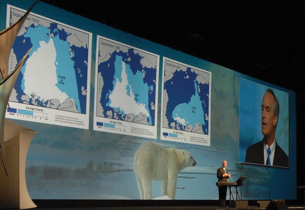
It further hit home for me earlier this year when I had to make a difficult decision on whether to list the polar bear as a threatened species under the Endangered Species Act. The decision was based on extensive geospatial information and mapping that showed the long-term threat to the polar bear’s sea ice habitat. As I weighed the decision, satellite imagery [illustrated below] helped make the case for listing. It also helped me explain the decision to the American people.
…
My vision for the future is that with the click of a mouse, decisionmakers and land managers…will have access to maps that Lewis and Clark could never have imagined—
- Maps that include up-to-date digital imagery of the landscape.
- Maps that overlay population data, land use, wildlife habitat, and other forms of geographic information, to paint a more complete picture of our planet.
…
Information is power, and this information will be a powerful tool in the hands of policy makers, land managers, and scientists in the United States and around the world.
Finally, the Department of the Interior will continue to partner with other countries, the importance of which I saw first-hand in December when I led the U.S. delegation to the World Summit of the Group on Earth Observations in South Africa. Seventy-three nations were there. The other leaders and I left that summit united in the belief that the world must embrace the idea of science without borders, achieve global data compatibility, and have full access to coordinated Earth observations. We agreed to focus on helping countries to better share data from their weather satellites, ocean monitoring buoys, earthquake sensors, and other geospatial technology.
…
As we look to the future, we can envision a time when we can use GIS to better see and predict other disasters, like drought and crop failures. That way we can pre-position food and prevent massive starvation. We can make a difference in peoples’ lives.
After all, we don’t inherit the Earth from our parents—we borrow it from our children.
1. Geospatial Line of Business
The Geospatial Line of Business (Geospatial LoB) is achieving the important goals of facilitating collaboration of geospatial-related activities and investments across all levels of government, optimizing and standardizing common geospatial functions to improve the quality of government services, and providing cost-efficient acquisition and access to geospatial data and services. The activities of the Geospatial LoB are spread across six work groups, each of which is contributing to the successful achievement of these goals. For the complete story, click here.
2. National Geospatial Advisory Committee
The Department of the Interior (DOI) established the National Geospatial Advisory Committee (NGAC) as a new Federal Advisory Committee that reports to the FGDC Chair. Secretary of the Interior Dirk Kempthorne appointed 28 members from a broad range of organizations to serve on the NGAC. The NGAC held its first two meetings in April and June 2008 and has adopted bylaws, a mission and statement, and operating procedures. The NGAC has provided advice and comments on key geospatial issues, including the Imagery for the Nation (IFTN) initiative and the Geospatial LoB. To read more information, click here.
3. Fifty States Initiative 2008
The Fifty States Initiative completed its third year in partnership with the National States Geographic Information Council (NSGIC). Eight new awards were made to support strategic and business plan development in a highly successful awardees kickoff meeting held in March. Thirty-three States, the District of Columbia, and the U.S. Virgin Islands have received about $1.7 million in funding during the past 3 years. A new contract to support the initiative has been awarded.For more information, click here.
4. International Activities
The FGDC continues to work closely with the Global Spatial Data Infrastructure (GSDI) organization. This year, the FGDC helped organize and conduct the GSDI–10 conference held in Trinidad and Tobago in February 2008 and supported this year’s GSDI Small Grants Program. Responsibility for regional GSDI newsletters was transferred to the respective regions, which was a significant milestone.
The FGDC maintains collaborative activities with Canada. The FGDC and Land Information Ontario agreed to work on outreach and training materials for the upcoming North American metadata profile. The sixth cross-border spatial data infrastructure project was launched in 2008 in partnership with GeoConnections. Click here for additional information.
5. Geospatial One-Stop
The Geospatial One-Stop (GOS) portal (www.geodata.gov) continued its steady growth in fiscal year 2008. With more than 165,000 individual metadata records contributed by 392 publishers, the portal saw a 7 percent increase in records from fiscal year 2007. The Interagency Working Group on Ocean and Coastal Mapping and the State GIS Inventory System were significant contributors to this successful increase in content. In addition, the number of portal users increased by 40 percent during the past year. GOS continued to focus on outreach and increasing participation with local governments and related associations, resulting in more web mapping services becoming available, primarily from major U.S. cities and metropolitan areas.
The GOS portal had several key enhancements implemented. These new enhancements also provide value to the data partnership site, Marketplace. The GOS Marketplace provides a means for organizations to advertise their interest in or intent to collect geospatial data, and to seek partners for cost-sharing. Approximately 2,500 Marketplace records were discoverable this year, and an estimated 250 contacts were made regarding possible partnerships for data acquisition. For the full story, click here.
6. Standards
The FGDC Standards Working Group promotes and coordinates FGDC standards activities. Highlights of the group’s accomplishments for fiscal year 2008 include the following:
- FGDC endorsement of the Geographic Information Framework Data Standard and the National Vegetation Classification Standard (Version 2.0).
- Delivery of a final draft of the Wetlands Mapping Standard.
- Public review of the draft Federal Trails Data Standard.
- Approval of a standards project to develop a Cultural Resources Geospatial Data Content Standard and Coastal and Marine Ecological Classification Standard.
- Public review of the North American Profile of ISO 19115:2003, Geographic Information—Metadata.
For more information, click here.
7. Imagery for the Nation
The Imagery for the Nation (IFTN) initiative advanced significantly in fiscal year 2008. IFTN was embraced by the FGDC Executive Committee in the spring of 2008. The FGDC Executive Committee has provided unprecedented executive leadership and commitment to a collaborative process that will accomplish near-term steps to move existing Federal imagery programs towards IFTN goals while a more comprehensive plan for full implementation of IFTN is developed. Seven work groups were established and have begun implementing their primary tasks to complete Phase 1 outcomes by the end of calendar year 2008.
The IFTN concept received endorsement by the NGAC in June 2008. Several issues were identified, and these are being addressed as part of the Phase 1 effort. For the complete story, click here.
8. New Executive Committee
In fiscal year 2008, the FGDC Executive Committee was established as a component of the FGDC Steering Committee. The Executive Committee was organized to facilitate action on key activities such as Imagery for the Nation (IFTN) initiative. The committee will help expedite decisions and provide guidance on issues before they are addressed by the Steering Committee. The Steering Committee will continue to make all final decisions. See Appendix A for the members of the Executive Committee. For more information, click here.
Success Stories
|
Providing Water To Fight Wildfires Challenge: The Evans Road Wildfire began on June 1, 2008, with a lightning strike. During the next 2 months, the fire grew and became entrenched in the deep peat soils found in the Pocosin Lakes National Wildlife Refuge (NWR) area. To contain these peat fires, large volumes of water were needed to flood the areas within the fire perimeter. Because of an ongoing drought in eastern North Carolina, however, the largest and closest body of water, Lake Phelps, was at a critically low level.
Action: The U.S. Fish and Wildlife Service geographic information system (GIS) specialists assigned to the fire were tasked with creating an elevation map of the area and mapping the drainage of the area to assist fire personnel in the most effective and efficient way to get water to the burning peat. Lidar data were used to create an elevation map of the area. The elevation map conveyed that the water would have to be moved from the lowest elevation in the eastern portion of the fire towards the west, which would mean that water would have to be progressively pumped with large-volume pumps. By using elevation data, fire managers were able to find the best route to flow the water. The GIS was also used to find alternate water sources to Lake Phelps.
Result: Fire managers were able to find and move water to the areas where it was most needed to combat the fire. The highest point of the fire served as the path of least resistance—millions of gallons per day of water was moved to flood the fire. By mid-July, water was being moved 43 miles from its source. This continued until August, when the flooding and rainfall were sufficient to contain the Evans Road Wildfire and pumping operations were ceased. |
|
National Vegetation Classification Standard Challenge: Develop a National Vegetation Classification Standard for use among Federal, State, Tribal, and local governments, academic institutions, and other partners.
Action: The U.S. Forest Service, which chairs the FGDC Vegetation Subcommittee, successfully finalized the National Vegetation Classification Standard. It was the culmination of more than a decade of effort by many Federal partners, including the National Park Service, the U.S. Fish and Wildlife Service, and the U.S. Geological Survey, and non-Federal partners, including the Ecological Society of America and NatureServe.
Result: The FGDC Steering Committee formally approved the National Vegetation Classification Standard on February 11, 2008. The Vegetation Subcommittee has begun developing an implementation plan for using the new standard in mapping vegetation data. The standard will produce nationally uniform Federal vegetation statistics. |
Geospatial Data Meets the Wildfire Challenge
Wildfires pose a serious threat to people, wildlife, and vegetation. They are a hazard that takes into account immediate topography, weather, and other environmental conditions and discounts boundaries, ownership, and land use. Although longer-term effects often follow, wildfires are immediate impact events that require only heat, air, and fuel to sustain their dangerous and often aggressive advancement. Suppressing these events to minimize the impact on life, limb, and property requires the best understanding of the terrain and contributing factors within and around wildfires. Reliable geospatial information and its analysis are vital to understanding, preparing for, responding to, and recovering from wildfires. The following is a sampling of geospatial programs and tools in use to combat wildfires.
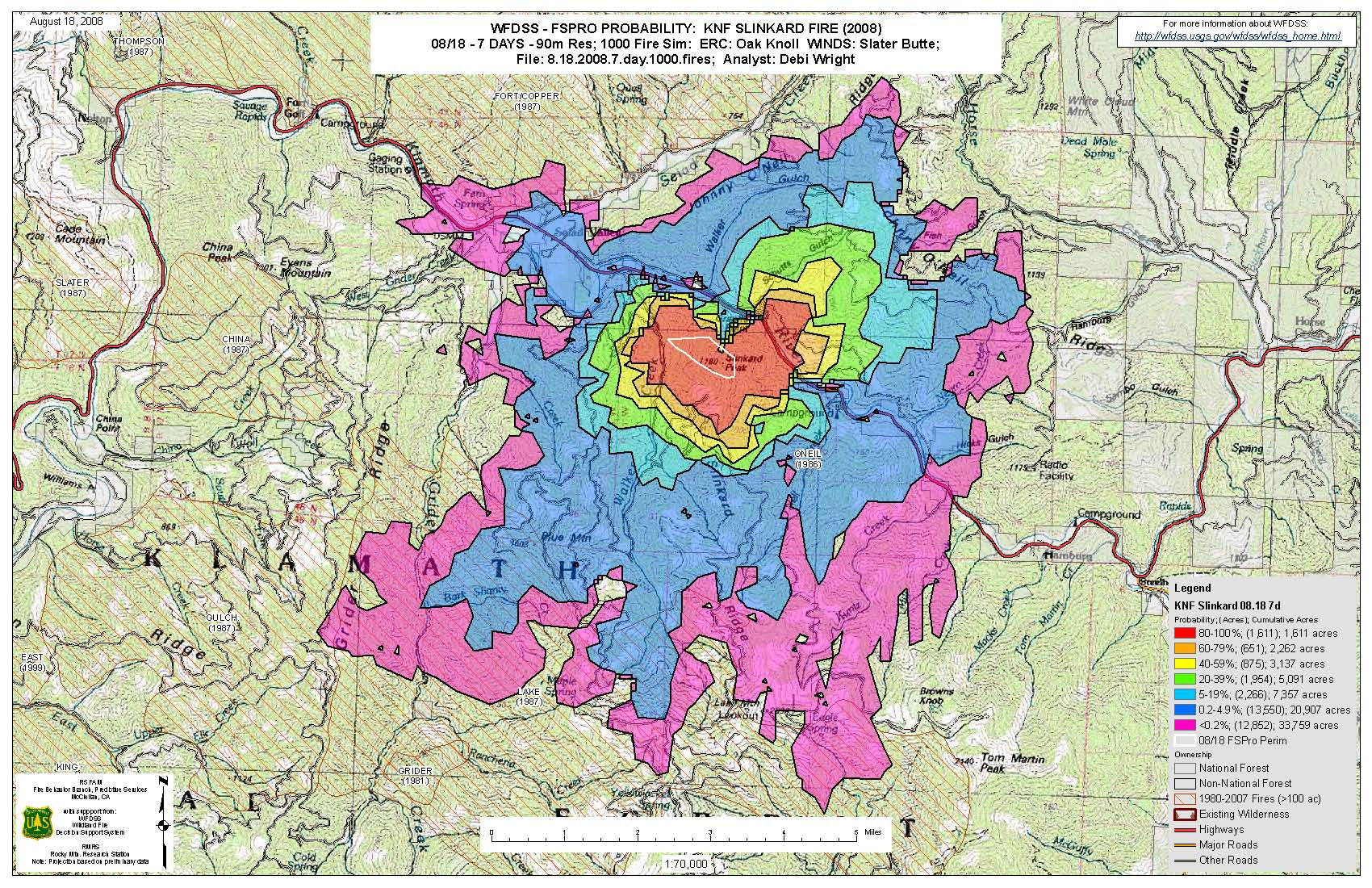
Slinkard Fire–2008 Klamath National Forest. Wildland Fire Decision Support System/Fire Spread Probability model analysis showing the probability that a fire would spread across the landscape given fuels, topography, and weather data. These inputs help managers determine planning and suppression responses.
Fire Research and Management Exchange System Promotes Information Exchange and Technology Transfer
The Fire Research and Management Exchange System (FRAMES) provides a systematic method of exchanging information and transferring technology between wildfire researchers, managers, and other stakeholders using FGDC-compliant standards. FRAMES uses web technologies to help bridge the gap between science and management and helps eliminate redundancy, reduce costs, and promote increased productivity and efficiency. The goal of FRAMES is to make wildfire data and other information easy to find, access, and use. FRAMES is a collaborative partnership among the U.S. Geological Survey, the U.S. Forest Service, and the University of Idaho.
Landscape Fire and Resource Management Planning (LANDFIRE) Data Helps with Modeling Fire Spread
Landscape Fire and Resource Management Planning (LANDFIRE) strives to produce consistent and comprehensive maps and data that describe vegetation, wildland fuel, and fire regimes for the United States. Although the main goal of LANDFIRE is to provide national level landscape-scale geospatial products to support fire and fuels management, LANDFIRE data have also been used in assessments of bighorn sheep viability, grizzly bear density, and bee pollination.
One important application of LANDFIRE data is its use in the Fire Spread Probability model, which is a spatial model that calculates the probability of fire spread from a current fire. Data for the model include canopy characteristics, fuel information, digital elevation data, and wind information. The fire spread probabilities are valuable for tactical planning of fire suppression efforts as well as for public and firefighter safety. When combined with data that describe structures, fire spread probabilities are useful for estimating the economic valuations of a fire. LANDFIRE partners include the U.S. Forest Service, the U.S. Geological Survey (USGS), The Nature Conservancy, and the National Interagency Fuels Technology Team.
Wildland Fire Decision Support System Aids Decisionmaking
A new system called the Wildland Fire Decision Support System (WFDSS) is designed to help fire managers determine the appropriate response for fire incidents. In WFDSS, the decisionmaker uses existing spatial data, including LANDFIRE data, and current spatial information about the fire to perform an analysis of the spread and impact of the wildfire. WFDSS uses the Fire Spread Probability model. The model simulates fires over the landscape. As the fire simulations overlap, probability bands are created. For example, in a simulation of 100 fires, a 90 percent probability occurs where 90 of the 100 fires overlap.
Additional analysis of resources threatened by a fire can be done using the WFDSS’ Rapid Assessment Values at Risk (RAVAR) model. This model uses critical infrastructure data and LANDFIRE data to analyze resources that may be at risk. The results are typically integrated with the probability bands to identify the likelihood of resources being threatened. The RAVAR model provides an economic assessment of values.
Another decision support tool available in the WFDSS is the Stratified Cost Index (SCI). This tool compares fire expenditures by projected fire size to historical fires within the same region. A range of projected fire sizes can be used to develop an estimated cost per acre for a fire. These cost comparisons during an active fire help to inform decisionmakers on suppression costs and strategies.
Land Parcel Data Bolsters Wildfire Response
The FGDC Cadastral Subcommittee has acquired as much available land parcel data as possible to support the analysis of and response to wildfire events. This data greatly aids the economic analysis done by RAVAR in the WFDSS. The most important element of RAVAR is the ability to map the location of private structures relative to potential fire spread. Knowing the location of structures relative to the fire dangers helps fire managers improve their decisionmaking.
The RAVAR delivered more than 130 wildfire risk maps and associated reports to large wildfire incidents across the United States during fiscal year 2008. This critical information helped in the allocation of scarce resources during the Santa Ana events in Southern California in October 2007 and the unprecedented Northern California fire events in the summer of 2008. In September 2008, the information was used to measure the increased wildfire potential due to forest downfall in east Texas from Hurricane Ike.
The FGDC Cadastral Subcommittee has made mission-critical contributions to the success of RAVAR and the new protocols for risk-based assessment for wildfire management. Quite simply, RAVAR would not exist in its current form without the land parcel data provided through the FGDC Cadastral Subcommittee.
Satellite Imagery Provides Strategic and Tactical Wildfire Information
To improve its ability to provide wildfire information, the U.S. Forest Service took action to provide near real-time information on the status and progression of fire activity in 2008 using satellite image data. The U.S. Forest Service also provided web-based geospatial applications to support fire management information needs and used the Moderate Resolution Imaging Spectroradiometer (MODIS) sensor to develop an Active Fire Mapping Program.
The MODIS Active Fire Mapping Program provides a near real-time geospatial overview of the current wildfire situation at regional and national scales. Locations of current fires and the extent of previous fire activity are determined using satellite imagery acquired by the MODIS sensor. These fire data are integrated with various sources of spatial data into a suite of geospatial data and mapping products. This information is used by fire managers to assess the current fire situation and serves as a decision support tool in strategic decisions regarding fire suppression resource allocation. The data and products provided by the program are also valuable for numerous other fire-related applications.
This program delivers a set of geospatial data products and applications that characterize current fire activity nationwide. It also provides data and map products, with FGDC-compliant metadata, that help characterize the effects of wildland fire activity for wildfire decision support. As of September 2008, the Active Fire Mapping Program website (activefiremaps.fs.fed.us/) had logged 1.5 million users that downloaded more than 3 terabytes of data.
| MODIS is the Moderate Resolution Imaging Spectroradiometer developed by NASA. The MODIS instrument is a polar orbiting, high temporal, moderate spatial resolution sensor that acquires remote sensing data for monitoring the Earth’s land, oceans, and atmosphere. The MODIS instrument is currently on board two NASA Earth Observing System satellites—Terra, launched in December 1999, and Aqua, launched in May 2002. |
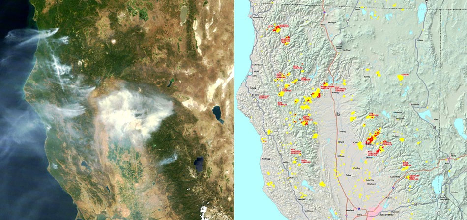
Moderate Resolution Imaging Spectroradiometer (MODIS) surface reflectance image of Northern California acquired by the Terra satellite on July 8, 2008 (left), and a corresponding MODIS fire detection map for the afternoon of July 8th (right). Red areas on the map indicate fire activity in the past 12 hours. Yellow areas are locations of cumulative fire activity that has occurred since January 1, 2008.
Unmanned Airborne Systems Promise to be Useful in Operational Fire Incidents
The U.S. Forest Service, in partnership with the National Aeronautics and Space Administration (NASA), continued the testing and evaluation of unmanned aerial systems for use in operational fire incidents. In a recent test, near real-time imagery was obtained using NASA’s Ikhana unmanned research aircraft. The aircraft has sophisticated new thermal-infrared imaging sensors capable of peering through thick smoke and haze to record hot spots and the progression of wildfires over a lengthy period of time. Images collected from the different sensors onboard were transmitted via satellite to a ground station where they were analyzed and transmitted as a Google Earth overlay to fire experts.

With smoke from the Lake Arrowhead, Calif., area fires streaming in the background, NASA’s Ikhana unmanned aircraft heads out on a wildfire imaging mission. Photograph by Jim Ross, NASA, photo ED07-0243-37, October 24, 2007.
Fire Boundary Coordinates Aid Recovery
In the summer of 2008, the Farm Service Agency (FSA) needed accurate information to identify the agricultural areas impacted by wildfires in California. Federal and private industry geographic information system (GIS) professionals were a large part of a nonfirefighter contingency that was sent to gather information by, in some cases, riding in helicopters to collect fire boundary coordinates. These coordinates were, in turn, shared with other Federal, State, and local agencies for response and recovery purposes.
The FSA used those coordinates to see what fields and producers were affected by the fires. By bringing the wildfire coordinates into a GIS and overlaying them with the digital field boundaries, called common land units, the FSA was able to see what fields and crops were impacted and what producers were affected by the fire. Damage assessments could be completed quickly, and the information was used to implement recovery programs, such as the Emergency Conservation Program.
Summary
Increased wildfire activity over the past several years has caused considerable damage to both public and private resources and has had profound effects on budgets and operational priorities of Federal agencies, as well as State and local entities with wildfire responsibilities. The geospatial community is responding. FRAMES promotes the sharing of interagency fire science research with managers. LANDFIRE provides data products that are needed to support fire management planning and prioritization. Decision support systems, such as the WFDSS, assist fire managers in determining the appropriate management response for fire incidents. Such tools as the RAVAR model allow decisionmakers to see the location of structures relative to the fire dangers and assess the economic impact of management decisions. Land parcel data is a key dataset for these analyses. Timely satellite imaging from MODIS provides information about active fires. Unmanned aircraft are beginning to bring new geospatial capability to wildfire response. Having coordinated geospatial information that is based on data standards ready for use in a GIS can facilitate the recovery from wildfires. Although it is unclear what the impact of wildfires will be in the future, it is clear that geospatial information and technology will play an ever increasing role in wildfire management.
FGDC: Leading the Development of Integrated Geospatial Capabilities
Geospatial Line of Business Develops a Strategic Plan
The participants in the Geospatial Line of Business (Geospatial LoB) initiative developed a strategic plan for achieving key goals and deliverables for the initiative and for the FGDC overall. The milestones and tasks within the strategic plan reflect a bottom-up analysis by each of the six Geospatial LoB work groups. Many of these tasks are expected to be fulfilled over a timeline that extends through 2013. Emphasis for 2008 was placed on common services and SmartBUY initiatives, data lifecycle management activities, and grants and procurement guidance. The work groups and their activities are summarized below.
The Common Services Work Group (CSWG) evaluates and expands cross-agency procurement opportunities and tool sharing to facilitate access to the best geospatial tools, software, and data. The CSWG has worked with the General Services Administration (GSA) SmartBUY Team to implement a multivendor blanket purchase agreement (BPA) that will provide Government users a common portfolio of geospatial technology options that benefit small-, medium-, and large-size agencies. CSWG developed the GEospatial Application Registry (GEAR) to give Government geospatial users the ability to nominate, share, and discuss geospatial software products and associated geo-enabling best practices.
The Lifecycle Management Work Group (LCWG) evaluates and defines the stages of the geospatial data lifecycle and identifies standard roles to facilitate the management of Government geospatial assets. The LCWG is tasked with developing supplemental guides that are in line with Office of Management and Budget (OMB) Circular A–16, including the following:
- Definition and processes for data lifecycle stages.
- Principles for assessing themes.
- Roles and responsibilities for agency officials.
- Geospatial lexicon of common terms.
- Coordination points for geospatial reporting.
The Grants and Contracts Work Group (GCWG) develops common policies, grants, cooperative agreements, contracts, and terms and conditions for geospatial information and services. GCWG drafted national guidelines for Federal grants, cooperative agreements, and contracts to help promote better access to data and services by all levels of government and by citizens. In addition, GCWG has helped develop requirements for the Geospatial One-Stop (GOS) portal (www.geodata.gov) to improve portal capabilities to locate and satisfy grants, cooperative agreements, and contracts compliance requirements.
The Technical Architecture Work Group (TAWG) develops geospatial requirements and recommendations for the technology and telecommunications infrastructure. The TAWG developed the Geospatial Profile of the Federal Enterprise Architecture (FEA) Version 2.0 to help chief architects determine how and where place-based approaches and associated geospatial resources fit into their enterprise architectures. The Geospatial Profile of the FEA also helps facilitate discussions with Government executives, program managers, and technical staff on how to enhance business operations and intelligence through geospatially enhanced enterprise architectures.
The Geo-Enabled Business Work Group (GEBWG) helps Federal program managers and executives take greater advantage of the benefits of geospatial applications. GEBWG developed the Geospatial LoB Communications Strategy and Implementation Plan and other outreach materials that describe the importance of “geo-enabling” information, including fact sheets, posters, and best practices from the 2008 FGDC Cooperative Agreements Program (CAP) projects. This work group’s role includes serving as the communications representative for outreach events.
The Performance Management Work Group (PMWG) provides greater transparency and accountability for Federal geospatial activities. The PMWG completed the Geospatial LoB Performance Management Plan and is reviewing OMB Circular A–16 to identify desired changes, particularly with respect to data themes and theme leads. The PMWG coordinates improved standardization, higher response rate, and more consistent reporting of geospatial investments by Federal agencies.
Milestones for these work groups will continue to be refined or expanded as the Geospatial LoB continues to mature. The accomplishments of the work groups serve as a starting point for meeting the overall goals of the Geospatial LoB. Additional milestones will be identified during the development of the Exhibit 300s for OMB for fiscal year 2010 and beyond. These additional milestones will facilitate the continued growth and success of the Geospatial LoB.
National Geospatial Advisory Committee Formed
In January 2008, Secretary of the Interior Dirk Kempthorne named 28 individuals to serve on the new National Geospatial Advisory Committee (NGAC). The NGAC was established to provide advice and recommendations on Federal geospatial policy and management issues and to provide a forum to convey views representative of partners in the geospatial community. The Committee is sponsored by the U.S. Department of the Interior on behalf of the FGDC member agencies.
Committee members were selected to provide a balanced representation of the various organizations involved in geospatial issues, including the private sector, nonprofit organizations, academic institutions, and various levels of government—Federal, State, Tribal, and local. Anne Hale Miglarese was appointed as Chair of the NGAC and Steven P. Wallach was appointed as Vice Chair. Ivan B. DeLoatch, FGDC Staff Director, serves as the Designated Federal Officer (DFO) for the committee. A complete listing of NGAC members is found in Appendix B.
Based upon feedback from the FGDC Steering Committee members, FGDC Chair James E. Cason identified several initial priority areas for the NGAC to address, including the following:
- Advancing the National Spatial Data Infrastructure (NSDI), with a focus on future roles and responsibilities of key players.
- Public-private partnerships, with a focus on minimizing or removing investment barriers that impede effective partnerships.
- Management of Federal geospatial resources, to include review of revisions to OMB Circular A–16 data themes being developed and coordinated through the Geospatial LoB.
- Prioritization and comment on specific programmatic issues regarding current data initiatives, such as Imagery for the Nation, The National Map, and National Land Parcel Data.
The NGAC held its first two meetings in April and June 2008. At these initial meetings, the committee adopted bylaws and a mission statement and established operating procedures. The NGAC also provided recommendations and advice on key geospatial issues, including the IFTN initiative and the Geospatial LoB.
In fiscal year 2009, the NGAC will continue to review and offer recommendations and comment on the FGDC priority areas. The NGAC will meet three or four times per year. NGAC meetings are open to the public, and members of the public will be invited to comment and make suggestions at all committee meetings.
Additional information about the NGAC is available at www.fgdc.gov/ngac.
National Geospatial Advisory Committee Leadership |
||
|---|---|---|
 |
NGAC Chair Anne Hale Miglarese, NGAC Chair, is a Principal with Booz Allen Hamilton Inc. Previously, she was the President and Managing Director of Fugro EarthData, Inc., a company that specializes in airborne mapping, remote sensing, and geographic information system (GIS) services. She served as chief of the Coastal Information Services branch of the National Oceanic and Atmospheric Administration’s Coastal Services Center and was a founding member of the National States Geographic Information Council.
|
|
 |
NGAC Vice Chair Steven P. Wallach, NGAC Vice Chair, is the Technical Executive with the National Geospatial-Intelligence Agency (NGA). He serves on the agency’s Executive Committee and leads NGA’s transformation efforts, including advancing geospatial intelligence, improving horizontal integration with community partners, fully enabling web services for geospatial intelligence access and collaboration, and moving towards foundation-based operations for the community. |
|
Cooperative Agreements Program Promotes NSDI
For more than 14 years, the FGDC has sponsored the Cooperative Agreements Program (CAP) with the goal of encouraging and enabling all levels of the geospatial data community to participate in the National Spatial Data Infrastructure (NSDI). The NSDI CAP provides organizations with more than funding; it also provides validation of the importance of an organization’s geospatial work and leads to new opportunities that may not have occurred without the CAP funding. CAP efforts have created collaborations within all sectors of government, developed an understanding of geospatial information in organizations and disciplines new to the NSDI, provided seed money to enable geospatial organizations to participate in the national effort to implement the NSDI, promoted the development of standardized metadata in hundreds of organizations, and funded numerous implementations of the Open Geospatial Consortium, Inc.’s (OGC) web mapping services and web feature services.
The more than 25 CAP projects completed in 2008 demonstrate the program’s range in scope and geography. A CAP project in Wisconsin, for example, resulted in a web feature services implementation for road network data in the State. Minnesota, North Dakota, and South Dakota partnered to promote shared client framework development and data services among the States and their local government organizations. South Carolina used the CAP funding to create My South Carolina Map (myscmap.sc.gov), a central gateway to geospatial information, and established a formal agreement among 11 State agencies and local governments. New Jersey developed and began hosting OGC-compliant web mapping services with metadata, as well as web feature services. In Washington, Pend Oreille County formed a GIS consortium and is providing integrated OGC-compliant geospatial datasets to The National Map. With a partnership between Ohio State agencies and the Federal Government, Ohio published a web mapping service for high-resolution imagery to the GIServOhio portal, The National Map, and the GOS portal. The metadata training and outreach projects resulted in more than 30 metadata workshops offered across the United States for a large number of diverse organizations and individuals. A sampling of the training materials created is available at www.rsgis.msu.edu/resources/metadata.
Under the 2008 CAP, funds were granted to 24 projects that addressed the six categories outlined below. Project descriptions and reports are available at www.fgdc.gov/grants/2008CAP/2008CAPDescriptions.
- The Metadata Trainer and Outreach Assistance category is designed to enable organizations with metadata expertise, knowledge, and experience to assist other organizations with training and implementation. CAP awarded assistance to four projects to advance metadata training.
- The Best Practices in Geospatial Service-Oriented Architecture (SOA) category supports the goals of the Geospatial LoB. The three awarded projects will design, deploy, and document reusable geospatial services and applications using SOA.
- The Fifty States Initiative category is designed to accelerate statewide coordination activities through consistent strategic and business plan development. CAP awarded assistance to eight States to begin developing State plans.
- The Joint Canadian and United States Spatial Data Infrastructure category is designed to stimulate cross-border cooperation over a geographic area through distributed data and services. The awarded project will focus on critical infrastructures.
- The Building Data Stewardships for The National Map and the NSDI category is critical to developing a national data inventory of consistent, seamless, integrated geospatial data. The CAP awarded assistance to four projects to foster stewardship of structures and transportation data.
- The FGDC-Endorsed Standards Implementation Assistance and Outreach (excluding Metadata Standards) category is designed to enable organizations with geospatial standards expertise, knowledge, and experience to help other organizations implement FGDC-endorsed standards. CAP awarded assistance to four projects to advance FGDC-endorsed standards.
The CAP budget for fiscal year 2009 is just slightly more than $1.3 million, and these funds will be used to support up to 26 projects. For more information about CAP, see www.fgdc.gov/grants.
Fifty States Initiative Reaches More States
This year marks the third year of the Fifty States Initiative. The primary focus of the Fifty States Initiative is the development of strategic and business plans for geospatial coordination statewide. As of September 2008, 17 States had finished developing their plans and several additional States had plans that were nearly completed.
In developing their plans, each State took the approach that best met its particular needs. For example, to build the business case for developing Iowa’s framework data, a rigorous return on investment (ROI) study for geospatial data was conducted. Indiana also performed an ROI that showed that more than $1.7 billion in economic activity depends on IndianaMap, which is the State’s geospatial data portal. Vermont’s plan focused on development of a geospatial enterprise architecture. Florida developed a statewide coordination strategy for improving response during emergencies. Here is what some of the awardees are saying about the Fifty States Initiative:
- Our experience with the program was very positive. The exposure at National States Geographic Information Council conferences to the wealth of information to assist with strategic planning was very helpful.
- This fifty State funding made a difference.
- This is the first statewide GIS committee.
The Fifty States Initiative is reaching a majority of the States and having a positive effect. The initiative will reach additional States in 2009 to help them establish a best practice framework for implementing geospatial coordination statewide. Preparations are also underway to develop the next steps for the initiative.

Map showing status of the Fifty States Initiative at the end of fiscal year 2008.
International Activities Advance Global Spatial Data Infrastructure
The FGDC facilitates the building of the NSDI while also promoting the creation of spatial data infrastructures (SDIs) globally. In collaboration with the University of the West Indies, the FGDC played a major role in organizing and conducting the Global Spatial Data Infrastructure Association’s 10th international conference (GSDI-10), which was held in Trinidad and Tobago in February 2008. GSDI conferences provide opportunities for geospatial experts and policymakers at local, regional, and global levels to interact for the purpose of considering how SDI developments can help address important worldwide needs.
The GSDI-10 conference program included opening and closing plenary sessions with keynote speakers, daily plenary sessions, technical paper sessions, pre-conference and post-conference workshops that were open to all registrants, a poster exhibit and competition, an exhibition area for highlighting agency initiatives and corporate product and service offerings, and numerous organized roundtable discussions to allow people from common regions of the globe or with common interests to present, discuss, and share issues, experiences, and plans. The conference resulted in roughly 200 papers and posters and about 400 registrants from more than 40 nations.
Another way in which the FGDC promotes the development of SDIs globally is as cosponsor of the GSDI Small Grants Program together with the GSDI Association and GisCorps, a program of the Urban and Regional Information Systems Association (URISA). Individual small grants of $2,500 and (or) in-kind support are awarded to individual national and subnational SDI efforts. In 2007, small grants were awarded as follows (by region): Africa (7), Asia and Pacific (3), Americas (2), and Europe (1). In 2008, the call for proposals closed on August 30, 2008, and 41 proposals were received from the following regions: Africa (22), Asia and Pacific (12), Americas (7). Thirty-one of these proposals will be sent to their respective regions for review and recommendations. The GSDI Association anticipates announcing 16 awardees early in fiscal year 2009.
In 2002, the FGDC started publishing a monthly electronic newsletter for Africa featuring SDI and GIS conferences, workshops, training, and accomplishments for the countries of Africa. As a result, communication among programs and awareness of projects on the continent were vastly improved and led to the establishment of a professional network for information exchange on geospatial activities. Similar newsletters were implemented for the Americas and the Asia and Pacific region in succeeding years. In 2008, the actual management and operation of these newsletters was moved to the respective regions. The FGDC continues to provide partial financial support for the publication and dissemination of these newsletters through the GSDI Association. The FGDC signed a letter of intent with Land Information Ontario (Canada) in fiscal year 2008 to develop training and promotional material for the upcoming North American Profile of ISO 19115:2003 Geographic Information—Metadata. A suite of training materials is being developed and made available to both U.S. and Canadian users of the standard. Ten or more guidance and implementation documents are being developed and jointly reviewed to ensure completeness and accuracy. The topics for these materials include an introduction to ISO Metadata, the North American Profile, implementation guides, and a cost-benefit analysis of implementing the NAP. The period covered by the joint agreement is May 2008 through November 2009.
The sixth joint U.S./Canadian SDI project, conducted in collaboration with GeoConnections (Canada), was announced and initiated in fiscal year 2008. This project, called “Cross-Border Content and Services for Critical Infrastructure Identification,” will deploy standards-based web mapping services and web feature services for critical structures databases and framework data for use in both the United States and Canada.
FGDC Metadata Program Coordinates and Collaborates
Work continues with the profile for metadata, which is being developed jointly by the American National Standards Institute (ANSI) and the Canadian General Standards Board. The resulting document will be called the North American Profile (NAP). An ANSI–sponsored public review of the NAP was held August 25 through October 6, 2008, followed by adjudication of the comments. The resulting North American Profile of ISO 19115:2003 Geographic Information—Metadata is intended to meet the geographical metadata needs of both countries. ANSI adoption of the NAP is anticipated during the first half of fiscal year 2009 with adoption by the FGDC Standards Working Group to follow thereafter.
The FGDC Metadata Program is developing materials, a workbook, a guide, and a graphic representation to facilitate the transition to the NAP, which will take place over a span of time. The NSDI Training Program has developed a lesson on the NAP, and additional training materials will be available early in 2009. The FGDC and Land Information Ontario agreed in mid-year 2008 to review and share their respective NAP educational materials.
The FGDC Metadata Program continues to assist NSDI stakeholders in metadata implementation. Direct consultation was provided to more than 50 Federal, State, academic, nonprofit, and private sector organizations. The Metadata Working Group was convened, via teleconference, during fiscal year 2008 to discuss metadata-related issues and activities. The group’s annotated meeting notes are available at www.fgdc.gov/participation/working-groups-subcommittees/mwg/index_html.
The Metadata Working Group led the development of an ISO 19115 Metadata Editor Review and solicited input from software developers and users. The latest version of the review is available at www.fgdc.gov/participation/working-groups-subcommittees/mwg/isoreview/index_html.
Geospatial One-Stop Continues to Grow and Improve
The Geospatial One-Stop (GOS) portal is the official means for accessing metadata resources managed in the National Spatial Data Infrastructure Clearinghouse Network. Metadata held by Federal, State, Tribal, and local entities, and by academic and nonprofit organizations, and the private sector are published through the Clearinghouse Network at www.geodata.gov.
With intergovernmental cooperation and support, the GOS portal continued its steady growth in fiscal year 2008 with the addition of more than 165,000 individual metadata records contributed by 392 publishers, which is a 7 percent increase in the number of records from the previous year. The efforts of the Interagency Working Group on Ocean and Coastal Mapping and the State GIS Inventory System contributed significantly to the increase in valuable content. In addition, the number of portal users averaged about 80,000 per month in fiscal year 2008, which represents an increase in traffic to the site of more than 40 percent. Through an interagency personnel agreement, GOS continued to focus on outreach and increasing the participation of local governments, which resulted in increased registration of web mapping services, primarily by major U.S. cities and metropolitan areas.
In fiscal year 2008, key enhancements to the GOS portal included improving the quality of linkages to live map services through implementation of the FGDC Map Service Checker and integration of the checker with the GOS portal search results. This upgrade provides publishers with tools for checking the quality of metadata and web mapping services. A second key enhancement was the introduction of an improved catalog service for the web interface, which greatly increases the speed at which the catalog’s content may be searched from outside systems. This enhancement also benefits Global Earth Observing System of Systems (GEOSS) catalog connection activities, given that GOS is a primary U.S. node in this international effort. A third enhancement is the improved classification of Federal publishers, which helps facilitate the reporting of Federal activities. This effort will also enhance reporting on metadata usage to publishers and upgrade metric reporting. Other enhancements to the GOS portal focused on taking advantage of new technologies and data types. For example, GOS now supports publishing of GeoRSS and Keyhole Markup Language (KML) content types and the use of representational state transfer (REST) interfaces to improve notification of new content.
These new enhancements also provide value to the data partnering opportunities available through the GOS Marketplace, which is a site where organizations can advertise their interest in or intent to collect geospatial data and seek partners to share the cost. This year, approximately 2,500 records were available for discovery via the Marketplace and an estimated 250 contacts were made regarding possible partnerships for data acquisition.
The GOS communities continue to improve, although some data categories need additional refinement to foster better collaboration. Communities are specialized areas for sharing information in specific data categories, such as administrative boundaries, agriculture, and the environment.
New content added to the GOS portal in fiscal year 2008 includes ocean and coastal data, fire mapping data, and hurricane data. In addition, a new historical data collection was added by the National Archives and Records Administration (NARA) and the U.S. Library of Congress. The FGDC Homeland Security Working Group took initial steps towards the publishing of public safety national datasets in the Homeland Security community.
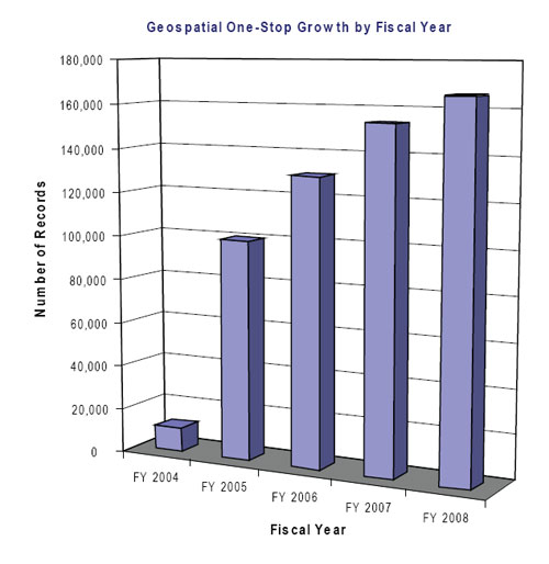
Graph showing growth in overall collection of geospatial data records over the past 5 years.

Example of Geospatial One-Stop service analysis report.
Standards are critical to the development, sharing, and use of geospatial data. The FGDC develops geospatial data standards for implementing the NSDI, in consultation and cooperation with State, Tribal, and local governments; academic institutions; the private sector; and, to the extent feasible, the international community.
The FGDC Standards Working Group promotes and coordinates FGDC standards activities; provides guidance on FGDC standards policy and procedures; facilitates coordination between subcommittees having overlapping standards activities; and reviews and makes recommendations on the approval of standards proposals, committee draft standards for public review, and final draft standards for FGDC endorsement.
The FGDC oversees the development of standards only when no equivalent voluntary consensus standards exist. OMB Circular A–119 directs Federal agencies to use voluntary consensus standards whenever possible. In addition, it directs Federal agencies to participate in voluntary consensus standards activities. To that end, the FGDC and its member agencies have joined the International Committee for Information Technology Standards (INCITS) Technical Committee L1 on Geographic Information. INCITS Technical Committee L1 is the means by which Federal agencies and non-Federal organizations participate in geospatial standardization activities of the ANSI and ISO, the International Organization for Standardization.
In May 2008, the FGDC endorsed the Geographic Information Framework Data Standard. This standard was created to enable data exchange for the seven NSDI Framework data themes (cadastral, digital orthoimagery, elevation, geodetic control, governmental unit boundaries, hydrography, and transportation) identified in OMB Circular A–16. FGDC endorsement enabled the Geographic Information Framework Data Standard to be freely available to producers and users.
In February 2008, the FGDC endorsed the National Vegetation Classification Standard (Version 2.0), which is a complete revision of the National Vegetation Classification Standard that the FGDC endorsed in 1997.
A final draft Wetlands Mapping Standard and adjudication of comments from public review that closed in fiscal year 2007 was submitted to the FGDC standards program manager in July 2008 in preparation for FGDC endorsement.
The FGDC approved release of the draft Federal Trails Data Standard for a 90-day public review period. Public review opened in May 2008 and closed in August 2008.
Two proposals for standards projects were approved in fiscal year 2008. The National Park Service has begun work to develop a Cultural Resources Geospatial Data Content Standard under the sponsorship of the FGDC Subcommittee on Cultural and Demographic Data. The FGDC Coastal and Marine Spatial Data Subcommittee has begun work to develop a Coastal and Marine Ecological Classification Standard.
INCITS Technical Committee L1 voted to recommend advancing the draft North American Profile of ISO 19115:2003, Geographic Information—Metadata to become an American National Standard (ANS). An ANSI-sponsored public review of the draft NAP opened on August 22, 2008. The ANSI-sponsored public review of the draft NAP lasts 45 days.
In addition, INCITS Technical Committee L1 voted to recommend advancing the draft Information Technology—Minimum Geographic Feature Identifying Attributes standard to become an ANS. The feature record identifier described in this draft standard supersedes the Federal Information Processing Standard (FIPS) 55 Place Code in the Geographic Names Information System (GNIS, geonames.usgs.gov). The ANSI-sponsored public review opened on November 30, 2007, and closed on January 14, 2008. The draft Information Technology—Minimum Geographic Feature Identifying Attributes standard is pending approval as an ANS.
NSDI Training Partnership Continues
The National Spatial Data Infrastructure (NSDI) Training Program continues to offer courses in partnership with the NSDI CAP and the USGS geospatial liaisons, as well as with the Federal Emergency Management Agency (FEMA) and the U.S. Fish and Wildlife Service (FWS). NSDI and metadata sessions are presented in courses offered several times per year at FEMA’s Emergency Management Institute and FWS’s National Conservation Training Center; they are also offered in the field quarterly. As part of FEMA’s multihazard and risk assessment cadre of classes, the components of the NSDI are invaluable as they relate to the analysis of potential losses from flood, hurricane winds, and earthquakes. All courses are well attended with students from Federal, State, Tribal, and local governments.
Since 2005, the FGDC has engaged in a partnership with Texas A&M University to support metadata training in the Gulf Coast region. In 2007, the project achieved great success in training regional councils in Texas. In fiscal year 2008, this project continued to use metadata training expertise from GeoMaxim, John C. Stennis Space Center, Radiance Technologies, Inc., and Texas A&M and coordination from the Texas State GIS Coordinator. The USGS geospatial liaisons from Alabama, Florida, Georgia, and Mississippi have been instrumental in coordinating training in the region. Two Train-the-Trainer and three Introduction to Metadata workshops have been held under this partnership. The Florida workshops will be delayed until 2009 because of hazardous travel conditions resulting from tropical storms and hurricanes.
The NSDI Training Materials Project added six new and updated lessons in fiscal year 2008. Information collected by a survey of users and a web performance assessment is being used to update the curriculum and project work plan. Key components of the updated work plan include the development of new lessons and a strategy for converting presentations to an online interactive learning environment. All lessons are available on the FGDC website for review, download, and (or) edit. Users of the lessons are encouraged to comment on the content and the value of the lessons. The lessons are available at www.fgdc.gov/training/nsdi-training-program/online-lessons#nsdi.
Imagery for the Nation Starts Phase 1
Building upon the cost-benefit analysis that was performed in 2007, the Imagery for the Nation (IFTN) initiative was advanced significantly in fiscal year 2008. In the spring, the newly formed FGDC Executive Committee embraced IFTN as its first leadership initiative. The NGAC also endorsed IFTN but identified several procurement, management, and strategic issues that need to be addressed.
Executive Champions have been selected to lead seven activity areas that make up the IFTN Phase 1 project, and Federal and State geospatial leaders from across the imagery community have been engaged to chair or participate in work groups for each of the activities. Together, the FGDC Executive Committee and the IFTN work groups are working to address the several issues identified by the NGAC and to develop a plan for implementing the IFTN.
The goal of the IFTN program is that “the Nation will have a sustainable and flexible digital imagery program that meets the needs of local, State, regional, Tribal and Federal agencies.” The IFTN is being designed as a Federal program conducted in partnership with State and local governments. The program plans to leverage resources across all levels of government to address their basic business needs. From the Federal perspective, the intent of IFTN is to address the needs of the Federal enterprise, including all agencies that acquire and (or) consume imagery products. The table lists the IFTN work groups and some of their current activities.
Imagery for the Nation Work Groups and Current Activities
|
Work Group |
Executive Champion |
Current Activities |
|
Technical Plan |
Charles R. Christopherson,
Jr. |
Document Federal imagery requirements, develop plans for rescoping existing programs, develop plans for the “to-be” IFTN program, and recommend an IFTN governance structure |
|
Funding Strategy |
James E. Cason |
Document Federal imagery expenditures, develop funding strategies for rescoping existing programs, and develop funding strategies for the “to-be” IFTN program |
|
Contracting Strategy |
Steven P. Wallach |
Document the practices and capacities of the existing Federal imagery contracting configuration and develop a contracting strategy for the “to-be” IFTN program |
|
Hosting and Archiving Strategy |
Joseph F. Klimavicz |
Document existing capacities and practices as a baseline to determine a hosting and archiving architecture for the “to-be” IFTN program |
|
Partnership Strategy |
Molly A. O’Neill |
Determine agreements vehicles for institutionalizing funding at the executive level for existing Federal imagery programs and for the "to-be" IFTN program |
|
Guidance and Direction |
Dominic Sale |
Develop guidance and direction for Federal agencies for implementing the “to-be” IFTN program |
|
Communications Strategy |
Charles J. Gay |
Establish an effective external communications process for the IFTN initiative during Phase 1 of the project, and develop a communications strategy for the "to-be" IFTN program |
Success Stories
|
Cadastral Data Challenge: Manage the complexity of cadastral data from more than 4,000 sources in the United States.
Action: The U.S. Bureau of Land Management Cadastral Survey needed to develop standard cadastral datasets based upon business needs, such as wildfire in the western States and designated priority areas in the East. The FGDC Cadastral Subcommittee supported gathering parcel data that could be pre-deployed to 418 counties.
Result: These data provided critical information to allocate scarce resources during the unprecedented Northern California fire events in the summer of 2008. |
|
Meeting the Data Needs of Agriculture Programs Challenge: Make up-to-date orthoimagery available for agriculture program administration, compliance, and management.
Action: The U.S. Department of Agriculture (USDA) Farm Service Agency (FSA) continued to implement the National Agriculture Imagery Program (NAIP) in 2008, acquiring 1-meter-resolution imagery in 20 States. Total program expenditures were $14.3 million, with other Federal and State partners contributing $4.2 million. NAIP imagery is in the public domain and is distributed through the USDA Geospatial Data Gateway portal. The data is discoverable through Geospatial One-Stop.
Result: NAIP acquires imagery annually during the growing season and provides timely imagery to support administration, management, and monitoring of USDA programs. The imagery is a valuable dataset for agriculture producers to improve operations and maximize crop output. Other Federal, State and local entities, and commercial and private interests use the imagery. The NAIP is a significant imagery data source for rural areas and small- to mid-sized urban areas; it also offers current imagery for pre-disaster baseline information and post-disaster assessment. |
|
Neighborhood Stabilization Challenge: Escalating housing foreclosures have had a devastating impact not only on individuals and families but on local neighborhoods and the broader economy. Foreclosures and long-term vacancy can have pernicious effects on the value of surrounding homes, the quality of life within communities, and the overall local economy in affected regions.
Action: Congress authorized the Department of Housing and Urban Development (HUD) to design a formula for allocating $3.92 billion to State and local governments for emergency assistance with redeveloping abandoned and foreclosed homes. HUD engaged a number of geospatially-enabled federal and publicly available data sources to create a transparent and equitable allocation formula for disseminating these funds. These public data capture several of the major elements that predict where foreclosures are occurring, falling home values, concentrations of high cost loans, and unemployment.
Result: Local governments and States are receiving funds in a timely, fair, and expeditious manner to help deal with the serious housing-related challenges in communities across the Nation. |
FGDC Goals for Fiscal Year 2009
1. Implement the Geospatial Line of Business
The Geospatial Line of Business (Geospatial LoB) has identified milestones for the six Geospatial LoB work groups. Key goals for fiscal year 2009 include the following:
- Make and implement changes to Office of Management and Budget (OMB) Circular A–16, Appendix E: Data Themes, Definitions, and Lead Agencies.
- Develop a repeatable process for modifying OMB Circular A–16 appendices and making recommendations for specific Circular A–16 changes.
- Establish two multiagency Enterprise License Agreements.
- Submit a proposal for Government-wide management of data lifecycles for significant geospatial datasets.
- Develop a timeline for changes to Federal acquisition regulations and Defense Federal acquisition regulations or additions to contracts with approval from the OMB.
- Deploy web services testing and requirements reporting for the Federal Enterprise Architecture.
2. Collaborate with the National Geospatial Advisory Committee (NGAC)
The National Geospatial Advisory Committee (NGAC) plans to hold three or four public meetings in fiscal year 2009. The FGDC will manage the review, disposition, and implementation of NGAC recommendations. Goals for the NGAC in fiscal year 2009 include the following:
- The NGAC will review and make recommendations on key geospatial policy and management issues, including transition recommendations, and issues related to national land parcel data, Imagery for the Nation, Geospatial LoB implementation, and strategies for The National Map.
- FGDC will review and respond to advice and recommendations from NGAC.
- FGDC will initiate and facilitate the next cycle of NGAC nominations and appointments.
3. Develop a National Strategy for Geospatial Information
The FGDC, with recommendations from the NGAC, will develop an initial framework for a National Strategy for Geospatial Information to strengthen our ability to advance the development of the National Spatial Data Infrastructure (NSDI).
4. Expand the Fifty States Initiative
In fiscal year 2009, seven new Fifty States Initiative awards are planned, with a kickoff meeting scheduled for February 2009. These awards are targeted at adding new States. Focus will be placed on the implementation of these plans. The next step will be to identify best practices for implementation. A workshop and other information gathering methods will be used to scope out the next steps for the Fifty States Initiative.
5. Continue International Collaboration and Leadership
The FGDC will continue to support the Global Spatial Data Infrastructure (GSDI) Association and its 11th international conference (GSDI-11), which will be held in June 2009 in Rotterdam, Netherlands. FGDC will also support the GSDI Small Grants Program. Furthermore, FGDC will continue its collaboration with foreign agency counterparts through existing agreements with Canada and Europe; specifically, by supporting technical assistance and information exchange on geospatial standards and practices through the intergovernmental Group on Earth Observations (GEO). Lastly, FGDC plans to coordinate and host [through the U.S. Geological Survey (USGS)] the Second Circumpolar Conference on Geospatial Applications (GeoNorth-II) to be held in August 2009 in Fairbanks, Alaska.
6. Enhance the Geospatial One-Stop Portal
A key goal for the Geospatial One-Stop (GOS) portal for fiscal year 2009 is to help develop a simplified search function to assist potential Federal grantees and contractors. Grantees or contractors must search for existing data before they begin acquisition of new data, and subsequently must ensure that the geospatial data they created through a Federal grant or contract process are published through the GOS portal. Another key goal in supporting the NSDI CAP is to lead projects that will take advantage of the GOS metadata catalog through open system interfaces.
The GOS team will continue to improve the quality and reliability of published linkages to web mapping services to enable easier sharing of ‘live’ data services. This will be accomplished by working closely with the USGS geospatial liaisons, State geographic information system (GIS) coordinators, agency partners, and The National Map program. In addition, new reports will provide better feedback to GOS publishers on how their data are being used. Other major efforts will focus on integration of the GOS portal with The National Map, supporting the Oceans and Coastal Mapping inventory, and continuing outreach efforts to further expand the GOS catalog.
7. Advance the Development and Acceptance of Standards
The following standards documents are expected to be completed in fiscal year 2009:
- Committee draft for the Address Data Standard, the Hydrologic Units Codes, and the Cadastral Data Content Standard, v1.4.
- Proposal to revise the FGDC-endorsed Standard for a U.S. National Grid.
- A final draft of the Federal Trails Data Standard and the Shoreline Data Content Standard.
- Working drafts of the Cultural Resources Geospatial Data Content Standard and the Coastal and Marine Ecological Classification Standard.
- A revised final draft of the Wetlands Mapping Standard.
- A new standard, Information Technology—Minimum Geographic Feature Identifying Attributes, which is scheduled to replace the existing standard for Geographic Names Information System (GNIS) identifiers.
8. Advance Imagery for the Nation
A key goal of Imagery for the Nation (IFTN) is to complete the Phase 1 project by the end of calendar year 2008 and to present the plan to the FGDC Steering Committee for review and decision on further action. The goal for Phase 1 is to develop a foundation that will provide momentum for continuing development and, eventually, funding to implement the IFTN vision. The project can then serve as a model for the coordination of other national data theme initiatives.
9. Improve National Land Parcel Data
The primary goal of the FGDC Cadastral Subcommittee is to work in collaboration with cadastral data producers and stakeholders to implement policies and procedures for standardizing and sharing cadastral data. In fiscal year 2009, the subcommittee plans to—
- Track and report progress in the use of cadastral data and standards.
- Establish standardized Public Land Survey Systems in seven States.
- Establish standardized parcel information in two Western States in support of wildfire management (the information should be sustainable and self-sufficient).
- Become the national coordinator for parcel data, pending approval and funding for three full-time positions in the U.S. Bureau of Land Management (BLM) as outlined in the National Land Parcel Data study.
- Obtain a CAP grant funding category for parcel information and fund it through the existing FGDC CAP at $600,000 per year for 5 years.
10. Support Homeland Security and Emergency Management
In fiscal year 2009, the FGDC Homeland Security Working Group (HSWG) plans to assist in preparing OMB Circular A–16 supplemental guidance that adds NSDI homeland security and homeland defense data themes and corresponding proposed lead agencies. It will support continued coordination and reviews of the U.S. Department of Homeland Security (DHS) Geospatial Data Model (GDM), including physical data model implementations, GDM documentation, and automated web-based tools intended to help users adopt the DHS GDM. Lastly, the HSWG will deal with issues associated with emergency management and other homeland security map symbol needs; specifically, expanding the ANSI emergency response symbol sets, supporting additional map scales, training, and defining additional symbol formats.
Success Story
|
Productive Lands and a Healthy Environment Challenge: Provide customers with authoritative geospatial data to help meet the U.S. Department of Agriculture (USDA) goals of productive lands and a healthy environment.
Action: The USDA enhanced and maintained the USDA Geospatial Data Gateway.
Result: The USDA’s Geospatial Data Gateway portal (datagateway.nrcs.usda.gov) processed more than 100.7 terrabytes of geospatial data for internal and external customers in fiscal year 2008. The most popular products were National Agriculture Imagery Program (NAIP) imagery; soils, common land units, and watershed boundary data; and elevation and base maps layers to support natural resource applications. |