The explosive growth of technologies that produce and leverage geospatial information has created enormous opportunities as well as considerable challenges for the Federal Government.
The effective use of geospatial information requires close coordination among the many agencies involved in its development. Office of Management and Budget (OMB) Circular A–16 was originally issued in 1953, revised in 1967, and revised again in 1990 and 2002. It created the Federal Geographic Data Committee (FGDC) as the interagency coordinating body to promote development, sharing, and dissemination of geospatial data. By Executive Order 12906 in 1994, the FGDC was charged to develop the National Spatial Data Infrastructure (NSDI).
The NSDI encompasses the technology, policies, standards, and human resources necessary to acquire, process, store, distribute, and improve utilization of geospatial data for a variety of users nationwide. The FGDC’s leadership role is critical as the importance of geospatial capabilities to improve the efficiency and effectiveness of government is recognized.
OMB Circular A-16 (revised August 2002) incorporates Executive Order 12906 and reaffirms the FGDC’s role to provide leadership for the NSDI with the coordinated development, use, sharing, and dissemination of the Nation’s geospatial data. In 2008, the National Geospatial Advisory Committee (NGAC) was established as a Federal advisory committee sponsored by the U.S. Department of the Interior.
FGDC Structure
The FGDC is governed by a steering committee that sets its high-level strategic direction. An Executive Committee of officials from agencies with a major geospatial component in their mission provides additional guidance to the steering committee. Advice and recommendations on Federal and national geospatial programs come from the NGAC. The Coordination Group advises on the FGDC’s day-to-day business, which is carried out by the FGDC Secretariat located at the U.S. Geological Survey in Reston, Va.
The FGDC infrastructure also includes committees, agency-led working groups and subcommittees, and collaborating partners representing organizations from State, Tribal, and local governments, as well as industry and academic and professional groups. All initiate and support the following activities crucial to expanding the NSDI:
- Developing and establishing the National Geospatial Data Clearinghouse on the Internet.
- Developing and implementing standards.
- Creating a national digital geospatial data framework. The framework covers seven fundamental geographic themes: geodetic control, elevation, orthoimagery, transportation, hydrography, governmental units, and cadastral information.
- Promoting collaborative relationships for sharing geospatial data among non-Federal partners.
- Developing policies and processes to better harmonize collective action.
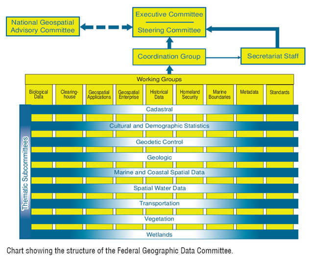
Chart showing the structure of the Federal Geographic Data Committee.
Steering Committee
The Steering Committee is the policy-level interagency group responsible for overseeing OMB Circular A–16-related activities and implementation of the NSDI. It provides executive leadership and establishes policy to coordinate geospatial activities between, among, and within Federal agencies. The Committee meets three to four times per year in Washington, D.C., and is composed of senior agency officials for geospatial information (SAOGIs).
The Secretary of the Interior or designee chairs the FGDC Steering Committee, which is composed of representatives from Federal organizations, including the Executive Office of the President and Cabinet-level and independent Federal agencies. The Deputy Director for Management of the OMB or designee serves as Vice Chair.
A subset of the Steering Committee, the Executive Committee, meets more frequently and is responsible for providing guidance and helping move forward critical decisions. The Executive Committee makes recommendations to the Steering Committee and provides a focal point for coordination with the NGAC.
| 2008 Steering Committee Members | ||
|---|---|---|
|
Chair, Deputy Secretary, U.S. Department of the Interior |
?James E. Cason |
|
|
Vice Chair, Administrator, Electronic Government and Information Technology (IT), Office of Management and Budget |
?Karen S. Evans |
|
|
U.S. Department of Agriculture |
*?Charles R. Christopherson, Jr. |
|
|
U.S. Department of Commerce |
*?Joseph F. Klimavicz |
|
|
U.S.Department of Defense |
*?Steven P. Wallach |
|
|
U.S. Department of Education |
*Mark Schneider |
|
|
U.S. Department of Energy |
*Tom Pyke |
|
|
U.S. Department of Health and Human Services |
*John L. Teetet |
|
|
U.S. Department of Housing and Urban Development |
*Darlene F. Williams |
|
|
U.S. Department of Homeland Security |
*?Richard F. Mangogna |
|
|
U.S. Department of the Interior |
*James E. Cason |
|
|
U.S. Department of the Interior |
Tim Petty |
|
|
U.S. Department of Justice |
*Vance E. Hitch |
|
|
U.S. Department of Labor |
*Patrick Pizzella |
|
|
U.S. Department of State |
*Susan Swart |
|
|
U.S. Department of Transportation |
*Dr. Steve Dillingham |
|
|
U.S. Department of the Treasury |
*Peter McCarthy |
|
|
U.S. Department of Veterans Affairs |
*Mark Gorenflo |
|
|
U.S. Environmental Protection Agency |
*?Molly A. O'Neill |
|
|
Federal Communications Commission |
Julius Knapp |
|
|
General Services Administration |
*Diane L. Herdt |
|
|
Library of Congress |
*Dr. John Hébert |
|
|
National Aeronautics and Space Administration |
*?Charles J. Gay |
|
|
National Archives and Records Administration |
*Michael J. Kurtz |
|
|
National Science Foundation |
*Jarvis Moyers |
|
|
Nuclear Regulatory Commission |
*Darren Ash |
|
|
Office of Personnel Management |
*Janet L. Barnes |
|
|
Small Business Administration |
*Michael P. McHale |
|
|
Smithsonian Institution |
vacant |
|
|
Social Security Administration |
vacant |
|
|
Tennessee Valley Authority |
*Roy Teal |
|
|
U.S. Agency for International Development |
*Michael Hess |
|
|
U.S. Army Corp of Engineers |
James C. Dalton |
|
*Designated Senior Agency official
for Geospatial Information
?Executive Committee Members
Coordination Group
The FGDC Coordination Group advises on the day-to-day business of the FGDC, carrying out the interagency coordination and implementation of the NSDI at the operational level. It also facilitates and oversees the work of the FGDC subcommittees and working groups. The Coordination Group meets monthly in Washington, D.C., and is composed of representatives from Federal agencies and collaborating partners.
| 2008 Coordination Group Members | |
|---|---|
|
U.S. Department of Agriculture |
|
|
USDA Geospatial Projects Manager |
Dennis Crow |
|
Natural Resources Conservation Service |
Marisa Capriotti |
|
U.S. Forest Service |
Betsy Kanalley |
|
Farm Service Agency |
Shirley Hall |
|
U.S. Department of Commerce |
|
|
U.S. Census Bureau |
Randy Fusaro |
|
National Oceanic and Atmospheric Administration |
Tony LaVoi |
|
U.S. Department of Defense |
|
|
Business Domain |
David LaBranche |
|
National Geospatial-Intelligence Agency |
Mark DeMulder |
|
U.S. Army Corps of Engineers |
Nancy Blyler |
|
U.S. Department of Education |
vacant |
|
U.S. Department of Energy |
David Morehouse |
|
U.S. Department of Health and Human Services |
vacant |
|
U.S. Department of Homeland Security |
Scott McAfee |
|
U.S. Department of Housing and Urban Development |
Jon Sperling |
|
U.S. Department of the Interior |
|
|
Bureau of Land Management |
Don Buhler |
|
Minerals Management Service |
Jim Fulmer |
|
National Park Service |
Joe Gregson |
|
U.S. Fish and Wildlife Service |
Doug Vandegraft |
|
U.S. Geological Survey |
Bob Pierce |
|
U.S. Department of Justice |
|
|
National Institute of Justice |
Lew Sanford |
|
U.S. Department of Labor |
vacant |
|
U.S. Department of State |
Ray Milefsky |
|
U.S. Department of Transportation |
Mark Bradford |
|
U.S. Department of the Treasury |
vacant |
|
U.S. Department of Veterans Affairs |
Dat Tran |
|
U.S. Environmental Protection Agency |
Wendy Blake-Coleman |
|
Federal Communications Commission |
Donald Campbell |
|
Federal Energy Regulatory Commission |
Susan Tseng |
|
General Services Administration |
John D'Alessandro |
|
Library of Congress |
Colleen Cahill and |
|
National Academy of Sciences |
Maria Uhle |
|
National Archives and Records Administration |
Brett Abrams |
|
National Aeronautics and Space Administration |
Francis Lindsay |
|
National Capital Planning Commission |
Shane Dettman |
|
National Science Foundation |
vacant |
|
Nuclear Regulatory Commission |
vacant |
|
Office of Personnel Management |
vacant |
|
Small Business Administration |
vacant |
|
Smithsonian Institution |
vacant |
|
Social Security Administration |
vacant |
|
Tennessee Valley Authority |
Charles Smart |
|
U.S. Agency for International Development |
vacant |
National Geospatial Advisory Committee
The National Geospatial Advisory Committee was established under the Federal Advisory Committee Act and is sponsored by the U.S. Department of the Interior. It is an advisory body that provides advice and recommendations on Federal geospatial policy and management issues and a forum to convey views representative of partners in the geospatial community. NGAC membership includes representatives from 28 Government and nongovernmental organizations. The NGAC holds public forums to discuss geospatial activities and solicits input from State, Tribal, regional, and local governments, academic institutions, and the private sector.
National Geospatial Advisory Committee Mission Statement
The mission of the NGAC is to provide advice on strategies regarding the creation, management, and dissemination of cohesive geospatial data, information, and knowledge to enable commercial, academic, and nonprofit organizations and all levels of government to more effectively—
- Empower and serve the public
- Protect the homeland
- Foster economic growth
- Advance science
- Manage the Nation’s resources
- Govern the Nation
- Prepare for and respond to emergencies
| 2008 National Geospatial Advisory Committee Members | |
|---|---|
|
Anne Hale Miglarese, NGAC Chair |
Booz Allen Hamilton Inc. |
|
Steven P. Wallach, NGAC Vice Chair |
National Geospatial-Intelligence Agency |
|
Sean Ahearn |
Hunter College?City University of New York |
|
Timothy M. Bull Bennett |
North Dakota Association of Tribal Colleges |
|
Michael Byrne |
State of California |
|
Allen Carroll |
National Geographic Society |
|
David J. Cowen |
University of South Carolina |
|
Jack Dangermond |
ESRI |
|
Donald G. Dittmar |
Waukesha County, Wisconsin |
|
Dennis B. Goreham |
State of Utah |
|
Kass Green |
The Alta Vista Company |
|
Randy Johnson |
Hennepin County, Minnesota |
|
Randall L. Johnson |
Metropolitan Council, St. Paul, Minnesota |
|
Jerry J. Johnston |
U.S. Environmental Protection Agency |
|
Barney Krucoff |
District of Columbia |
|
Timothy Loewenstein |
Buffalo County, Nebraska |
|
David F. Maune |
Dewberry |
|
Charles Mondello |
Pictometry International |
|
Zsolt Nagy |
State of North Carolina |
|
Kim Nelson |
Microsoft Corporation |
|
Matthew O'Connell |
GeoEye |
|
John M. Palatiello |
Management Association for Private Photogrammetric Surveyors |
|
Jay Parrish |
State of Pennsylvania |
|
G. Michael Ritchie |
Photo Science |
|
David Schell |
Open Geospatial Consortium, Inc. |
|
Eugene A. Schiller |
Southwest Florida Water Management District |
|
Christopher Tucker |
ERDAS, Inc. |
|
Ivan B. DeLoatch, NGAC Designated Federal Officer (DFO) |
Federal Geographic Data Committee |
Secretariat Staff
The FGDC Secretariat Staff provides support for the FGDC subcommittees and performs the following tasks:
- Administers the FGDC standards program.
- Initiates and participates in FGDC Subcommittees and working groups.
- Drafts policies and procedures for consideration and approval by the Coordination Group, Steering Committee, and Executive Committee.
- Provides support to the National Geospatial Advisory Committee (NGAC).
- Administers the NSDI Cooperative Agreements Program (CAP).
- Administers the FGDC International Spatial Data Infrastructure program.
- Manages the NSDI training and outreach program.
- Maintains the FGDC web site.
- Manages all administrative requirements associated with scheduling and conducting meetings.
- Undertakes staff analysis, technical development, and other activities on behalf of the Coordination Group.
| 2008 Secretariat Staff | |
|---|---|
|
Staff Director |
Ivan DeLoatch |
|
Deputy Staff Director |
Kenneth Shaffer |
|
Senior Advisor to Staff Director |
John Mahoney |
|
Senior Program Analyst |
Lew Sanford |
|
Program Assistant |
Carol Greenough |
|
Program Assistant |
Vanessa Hardnett |
|
Secretary |
Arista Salimi Mahar |
|
Clearinghouse Coordinator |
Doug Nebert |
|
FGDC Interagency Liaison |
Patricia Phillips |
|
Framework and Cooperating States Coordinator |
Milo Robinson |
|
Metadata Coordinator |
Sharon Shin |
|
Standards Coordinator |
Julie Binder Maitra |
|
Training and Education/Tribal Liaison Coordinator |
Bonnie Gallahan |
|
NSDI CAP Coordinator |
Brigitta Urban-Mathieux |
|
Webmaster |
Vaishal Sheth |
|
Program Analyst |
Roxanne Lamb |
Thematic Subcommittees
OMB Circular A–16 enumerates 34 data themes of national significance and assigns responsibility for each of the themes to one or more Federal agencies. FGDC thematic subcommittees are established for nine of the data themes.
Federal agencies lead the thematic subcommittees; each subcommittee focuses on a particular NSDI spatial data theme. Lead agency responsibilities and new data themes may be added or altered by FGDC recommendation and OMB concurrence.
Definitions of the nine active thematic subcommittees appear in the table to the right.
| Thematic Subcommittees by Lead Agency and Definition | ||
|---|---|---|
|
Thematic subcommittee |
Lead agency |
Definition of spatial data theme |
|
*Cadastral |
DOI BLM |
The geographic extent of past, current, and future right, title, and interest in real property; the framework to support the description of that geographic extent. Geographic extent includes survey and description frameworks. |
|
Cultural and Demographic Statistics |
DOC USCB |
Geospatially referenced data that describe characteristics of people: nature of structures in which they live and work; economic and other activities they pursue; facilities they use to support their health, recreational, and other needs; environmental consequences of their presence; boundaries, names, and numeric codes of geographic entities used to report information collected. |
|
*Geodetic Control |
DOC NOAA |
Common reference system for establishing coordinates for all geographic data. All NSDI framework data and users' applications data require geodetic control to accurately register spatial data. The National Spatial Reference System is the fundamental geodetic control for the United States. |
|
Geologic |
DOI USGS |
Geologic mapping information and related geoscience spatial data that can contribute to a National Geologic Map Database as pursuant to Public Law 106-148. |
|
Marine and Coastal Spatial Data |
DOC NOAA |
The subcommittee, through its member agencies and the FGDC, develops strategic partnerships, relevant standards, collaborative tools, and outreach that will enhance access to and utility of coastal and ocean framework data. |
|
*Spatial Water Data (Advisory Committee on Water Information) |
Co-leaders: DOI USGS and USDA NRCS |
The Advisory Committee on Water Information (ACWI) advises the Federal Government, through DOI USGS, on the coordination of Federal water information programs. The purpose of ACWI is to represent the interests of water information users and professionals on activities and plans related to Federal water information programs and the effectiveness of those programs in meeting the Nation’s water information needs. |
|
*Transportation |
DOT BTS |
Used to model geographic locations, interconnectedness, and characteristics of transportation systems in the United States; includes physical and nonphysical components representing all modes of travel that enable movement of goods and people between locations. |
|
Vegetation |
USDA Forest Service |
Collection of plants or plant communities with distinguishable characteristics that occupy an area of interest. Existing vegetation covers or is visible at or above land or water surface and does not include abiotic factors that tend to describe potential vegetation. |
|
Wetlands |
DOI FWS |
Provides classification, location, and extent of wetlands and deepwater habitats; no attempt is made to define the proprietary limits or jurisdictional wetland boundaries of any Federal, State, or local agencies. |
*
Indicates framework theme.
Note: Abbreviations are defined in the glossary in Appendix D.
FGDC Working Groups
Working groups crosscut the subcommittees and focus on infrastructure issues common to many of the NSDI data themes. Descriptions of the active working groups are listed in the table below.
| FGDC Working Groups by Lead Agency and Description | ||
|---|---|---|
|
Working group |
Lead agency |
Description |
|
Biological Data |
DOI USGS BRD |
The Biological Data Working Group promotes development and coordination of standards for biological data in order to increase compatibility in the development, use, sharing, and dissemination of biological data among government agencies and other interested institutions. The working group develops means to facilitate the sharing and consistent use of biological data standards and protocols, and encourages interagency partnerships in developing and implementing these standards and protocols. The working group helps integrate biological data standards activities into the National Spatial Data Infrastructure and the National Biological Information Infrastructure. |
|
Clearinghouse |
DOI USGS |
FGDC is tasked by Executive Order 12906 to develop procedures for and assist in the implementation of a distributed discovery mechanism for digital geospatial data. Using the data elements defined in the FGDC Metadata Standard, governmental, nonprofit, and commercial participants publish their geospatial resources to the Clearinghouse Network. |
|
Geospatial Enterprise Architecture Community of Practice |
DOI USGS |
The primary objective of the Geospatial Enterprise Architecture Community of Practice (COP) is to improve the understanding and integration of geospatial concepts by mainstream governmental business planners and technical practitioners through a variety of outreach mechanisms. The COP was convened through the request of the Architecture and Infrastructure Committee of the Chief Information Officer (CIO) Council and FGDC to develop guidance known as the "Geospatial Profile of the Federal Enterprise Architecture (FEA)." |
|
Historical Data |
NARA |
The Historical Data Working Group promotes an awareness among Federal agencies of the historical dimension to geospatial data; to facilitate the long-term retention, storage, and accessibility of selected historically valuable geospatial data; and to establish a mechanism for the coordinated development, use, sharing, and dissemination of historically valuable geospatial data that have been financed in whole or part by Federal funds. |
|
Homeland Security |
DHS |
The Homeland Security Working Group ensures that the NSDI supports the preparation for, prevention of, protection against, response to, and recovery from threats to the Nation's population centers and critical infrastructures that are of terrorist, criminal, accidental, or natural origin and related adverse events. |
|
Marine Boundary |
DOC NOAA and DOI MMS |
The Marine Boundary Working Group fosters integrated approaches to the legal and geospatial descriptions of marine boundaries and mapping of marine boundary features within the territorial waters of the United States. The goals of the working group are to make maximum use of public resources to avoid duplicating efforts; provide a venue for communicating and coordinating on marine boundary activities; and to use standardized methodologies to produce more complete and usable marine boundary data, metadata, and charts. |
|
Metadata |
DOI USGS |
The Metadata Working Group promotes and coordinates geospatial metadata activities among FGDC member agencies in support of the NSDI. The Metadata Working Group promotes awareness among FGDC member agencies of the metadata dimension to geospatial data; facilitates the evolution and revision of the Content Standard for Digital Geospatial Metadata; and establishes a mechanism for the coordination, development, use, sharing, and dissemination of geospatial metadata among FGDC member agencies. |
|
Standards |
DOI USGS |
The FGDC Standards Working Group (SWG) actively promotes and coordinates FGDC standards activities. The SWG provides guidance on FGDC standards policy and procedures, facilitates coordination between subcommittees having overlapping standards activities, and reviews and makes recommendations on the approval of standards proposals, draft standards for public review, and draft standards for FGDC endorsement. |
Note: Abbreviations are defined in the glossary in Appendix D.
Collaborating Partners
The FGDC involves public interest groups who participate within the committee structure to ensure that their needs are included in developing the NSDI. These collaborating partners include State, Tribal, and local governments; academic institutions; and a broad array of private sector geographic, statistical, demographic, and other business information providers and users. NSDI strives to build upon local data wherever possible.
Collaborating partnerships are open to public, private, and nonprofit organizations with missions complementary to the FGDC. Organizations interested in becoming partners are invited to send a written request to the FGDC Chair. Current non-Federal collaborating partners include the organizations listed to the right.
| Collaborating Partners and Descriptions | |
|---|---|
|
Partner |
Description |
|
American Congress on Surveying and Mapping (ACSM) |
A nonprofit educational organization that advances the sciences of surveying and mapping and related fields to further the welfare of those who use and make maps. |
|
Association of American Geographers (AAG) |
A scientific and educational society whose members share interests in the theory, methods, and practice of geography and geographic education. |
|
Cartographic Users Advisory Council (CUAC) |
An organization of representatives from national and regional library organizations, dedicated to cartographic interests. |
|
Geospatial Information and Technology Association (GITA) |
A nonprofit educational association serving the global geospatial community. |
|
International City/County Management Association (ICMA) |
A professional and educational organization for chief appointed managers, administrators, and assistants in cities, towns, counties, and regional entities throughout the world. |
|
National Association of Counties (NACo) |
Advances issues with a unified voice before the Federal Government, improves the public's understanding of county government, assists counties in finding and sharing innovative solutions through education and research, and provides value-added services to save counties and taxpayers money. |
|
National Association of State Chief Information Officers (NASCIO) |
Represents State CIOs and information resource executives and managers from the 50 States, the District of Columbia, and 6 U.S. territories. |
|
National League of Cities (NLC) |
Strengthens and promotes cities as centers of opportunity, leadership, and governance. |
|
National States Geographic Information Council (NSGIC) |
Provides a unified voice on geographic information and technology issues, advocates State interests, and supports its membership in their statewide initiatives. |
|
Open Geospatial Consortium, Inc.® (OGC) |
A nonprofit, international, voluntary consensus standards organization of more than 365 companies, government agencies, research organizations, and universities; leads the development of standards for geospatial and location-based services. |
|
University Consortium for Geographic Information Science (UCGIS) |
A nonprofit organization of more than 50 universities and other research institutions. |
|
Urban and Regional Information Systems Association (URISA) |
Facilitates the use and integration of information technologies to improve the quality of life in urban and regional environments. |
|
Western Governors' Association (WGA) |
Addresses important policy and governance issues in the West, advances the role of the western States in the Federal system, and strengthens the social and economic fabric of the region. |
Note: Abbreviations are defined in the glossary in Appendix D.
Appendix B