 Contents
Message from the FGDC Chair
Doug D. Nebert NSDI Champion of the Year Award
Highlights for Fiscal Year 2015
National Geospatial Advisory Committee—Collaborating for Results
Fiscal Year 2015 Accomplishments—Achieving the NSDI Strategic Plan
Goals for Fiscal Year 2016
FGDC Subcomittees and Working Group Reports
Appendix A. FGDC Leadership Profiles
Appendix B. FGDC Structure and Membership
Appendix C. National Geospatial Data Asset Themes
Appendix D. Fiscal Year 2015 FGDC Office of the Secretariat Financial Summary
Appendix E. NSDI Strategic Plan—Fiscal Year 2015 Performance Summary
Appendix F. Glossary of Abbreviations and Terms
Message from the FGDC Chair
I am pleased to present the Federal Geographic Data Committee's (FGDC's) annual report for fiscal year 2015. This report provides a summary of program, management, budget, and performance information and describes the FGDC's actions over the past year to facilitate sustainable development and dissemination of geospatial data and technology. These actions support important initiatives, such as the Digital Government Strategy, the Open Data Initiative, and Information Technology Shared Services.
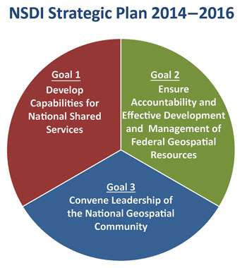
Throughout 2015, the FGDC continued to have a primary focus on achieving the goals in the 2014–2016 National Spatial Data Infrastructure (NSDI) Strategic Plan. The strategic plan describes a shared national vision for the NSDI and includes a clear set of three goals with objectives for the Federal role in achieving this vision
Goal 1 is to develop nationally shared services. The FGDC continued to make significant progress in developing the Geospatial Platform, which is a critical tool for providing shared services and capabilities. With new support available, the team made significant progress and enhancements to the Platform, which includes a redesigned Web site and a Web map viewer and gallery. The FGDC endorsed the Geospatial Interoperable Reference Architecture (GIRA), which provides a framework for the management, design, development, and alignment of new or existing geospatial system/solution investments. In addition, a new geospatial cloud-hosting contract awarded this year will provide access to cloud-hosting services to FGDC agencies.
Goal 2 is to ensure accountability and effective management of Federal geospatial resources. The primary emphasis is to continue to implement the National Geospatial Data Asset (NGDA) Management Plan. This process will provide a sustainable means for managing and monitoring Federal investments in geospatial assets. The focus in 2015 was developing a process to more effectively manage our investments and building the foundation for more effective portfolio management. I would like to thank the NGDA Theme Leads and Dataset Managers from all the FGDC Federal agencies who worked together to fulfill the responsibilities identified for them in the NSDI Plan.
Goal 3 is to convene leadership of the national geospatial community. This goal is about promoting partnerships and collaboration with Federal agencies, as well as with external partners like the National Geospatial Advisory Committee (NGAC), which includes representation from multiple organizations across the country. The role and contributions of the NGAC are highlighted in this report. The FGDC also continued its leadership and participation in the development and coordination of standards and metadata applicable to the geospatial community. The FGDC endorsed five new standards in 2015, and the FGDC Geospatial Metadata Program engaged in several activities to support the Data.gov and Geospatial Platform initiatives and the implementation of ISO geospatial metadata.
We have made great progress in geospatial programs over the last year—from establishing the Geospatial Platform, to developing and implementing the goals of the NSDI Strategic Plan and the NGDA Management Plan, to developing initiatives, such as the Open Water Data Initiative and the 3D Elevation Plan. This Administration has until the end of 2016 to make a final push on key geospatial priorities, and I challenged the NGAC and the FGDC community to think strategically about what we can do together to make an impact over the coming year. Our community has accepted this challenge, and fiscal year 2016 will focus on our continued collaboration with partners to advance critical national geospatial initiatives and ensure a smooth transition into the next Administration.
We are looking forward to advancing progress and partnerships in the coming year.
Sincerely yours,
Jennifer Gimbel
FGDC Chair
Principal Deputy Assistant Secretary for Water and Science
Department of the Interior
Doug D. Nebert NSDI Champion of the Year Award

In 2014, the FGDC announced the establishment of the Doug D. Nebert National Spatial Data Infrastructure (NSDI) Champion of the Year Award in honor of a respected colleague, technical visionary, and recognized national and international leader in the establishment of spatial data infrastructures. Details of the nomination and award process will be made available toward the end of 2015 via the FGDC Web site with the first award anticipated to be announced in 2016.
The vision of the NSDI is to assure that spatial data from multiple sources—Federal, State, Tribal, regional, and local governments, academia, and the private sector—are available and easily integrated to enhance the understanding of our physical and cultural world. Each year, the award will be announced in the FGDC Annual Report and will be presented to an individual or team representing Federal, State, Tribal, regional, and (or) local governments, academia, or nonprofit and professional organizations for development of an innovative and operational geospatial tool, application, or service capability used by multiple organizations.
This NSDI award will be based on the following foundational precepts:
- Innovation and vision
- Interoperability
- Use of standards
- Advancement of NSDI principles
- Service to communities of users
- Developed once, used by many
- Improved performance and service
- Real-world application
The FGDC's counterpart in Europe is the Infrastructure for Spatial Information in the European Community (INSPIRE) and it has established the INSPIRE Conference Excellence Award in memory of Doug Nebert and Christiner Giger to recognize excellence in geoinformation technologies. In June, the award went to Geosparc, lat/lon, and wetransform ( ec.europa.eu/jrc/en/event/conference/inspire-gwf-2015).
Highlights for Fiscal Year 2015
Implementation of the National Spatial Data Infrastructure (NSDI) Strategic Plan continued into its second of 3 years. The FGDC community worked collaboratively to complete actions and tasks related to six of the nine objectives called out in the plan. For more information see Fiscal Year 2015 Accomplishments and Appendix E.
Geospatial Interoperable Reference Architecture. The Geospatial Interoperable Reference Architecture (GIRA) defines governance and an oversight framework for executive leadership to manage geospatial program and acquisition decisions, and provides technical architecture guidance on the design and implementation of an interoperable geospatial solution. After an interagency review, the GIRA was endorsed this year by the FGDC. The geospatial stakeholder community also provided feedback. For more information click here.
Geospatial Platform. The third iteration of the Geospatial Platform (Geoplatform.gov) Web site was released this year, and features a number of new capabilities and a greatly expanded collection of trusted geospatial data, services, and applications. The new Web site features advanced tools for allowing users to quickly view data, create interactive maps, and to share these products with users, either within the Communities and Map Gallery of the Geospatial Platform or on their own Web sites. Additionally, in support of the FGDC efforts to implement portfolio management for the collection of National Geospatial Data Assets, advanced user survey capabilities and the first version of an interactive reporting dashboard were released this year as new functions of the Geospatial Platform. For more information see click here.
GeoCloud. The FGDC's GeoCloud initiative sponsored the operational deployment of key public-facing geospatial Web services and engaged several new projects as part of the shared services strategy to advance the Geospatial Platform. The GeoCloud served as an incubator for projects that provided data, information, applications, tools, and services related to national efforts in biodiversity, climate, public health, environmental health, housing affordability, water use and availability, social, economic, and environmental subject areas. For more information click here.
NGDA Management Plan. The FGDC Federal agencies continued their efforts to accomplish the actions described in the National Geospatial Data Asset (NGDA) Management Plan, which support implementation of the Office of Management and Budget (OMB) Circular A–16 Supplemental Guidance. This year, an additional 5 of the 27 actions described in the plan were completed (for a total of 10 completed actions) and several activities are underway to support the remaining actions. The completed actions included registering metadata for baseline NGDA Datasets in the catalog that serves Data.gov and Geoplatform.gov, approving a process for the nomination and removal of NGDA Datasets within the A–16 NGDA Portfolio, establishing A–16 Theme collaboration communities on Geoplatform.gov, developing the NGDA Dataset maturity assessment survey, and developing a template for NGDA Theme strategic plans. In addition, an interagency completed documenting the definitions of geospatial investment. For more information click here.
NGDA Portfolio Management. National Geospatial Data Asset (NGDA) Theme Leads and Dataset Managers worked together to advance portfolio management and fulfill the responsibilities identified in the NGDA Management Plan, including the registration of all NGDA Datasets in the catalog used by Data.gov and the Geospatial Platform. Theme Leads reached out to groups with shared interests to increase communications and optimize resources for future efforts and Dataset Managers oversaw the improvement to several NGDA Datasets. The focus at the end of the fiscal year was completing the baseline NGDA Dataset Lifecycle Maturity Assessments that will form the foundation for informed portfolio reporting. For more information click here.
Standards. The FGDC continued its leadership and participation in the development and coordination of national and international standards. The FGDC endorsed five standards in 2015: the Aeronautical Information Exchange Model (AIXM) 5.1; ISO/IEC 15444-1:2004 Technical Corrigenda 1:2007 and 2:2008 JPEG 2000; OGC GeoPackage 1.0; Geopolitical Entities, Names, and Codes (GENC) Standard Edition 2; and GeoRSS-Simple and GeoRSS-GML. February 2015 marked the fourth anniversary of the monthly standards update. For more information click here.
Geospatial Metadata. The FGDC Geospatial Metadata Program activities focused on supporting the implementation of the International Organization for Standardization (ISO) geospatial metadata standards and increasing access to geospatial metadata through the Data.gov and Geoplatform.gov shared catalog. The NSDI stakeholders shared implementation experiences each month through the FGDC-hosted ISO Geospatial Metadata Implementation Forum. An update to the online ISO Geospatial Metadata Editor Registry was developed and released with software developers and users providing information about tools that support creation of ISO metadata. Through the NGDA Metadata Focus Group, the Theme Leads and Dataset Managers were provided recommendations that enabled all NGDA Datasets to be registered and discovered in Data.gov and Geoplatform.gov catalog. Activities have engaged the community and provided a mechanism where public and private sector members can share their metadata experiences, expertise, and resources. For more information click here.
National Geospatial Advisory Committee (NGAC). This year, the NGAC and its subcommittees focused on providing feedback and recommendations to the FGDC in the areas of geospatial privacy, crowdsourced geospatial data, the Landsat Program, the 3D Elevation Program, and NSDI and Geospatial Platform outreach and communications. For more information click here.
International Activities. The FGDC actively supported international efforts through several groups. The FGDC Global Geospatial Information Management (GGIM) Working Group represented the United States at several international meetings held throughout the year and supported the passage of a proposal from the United Nations Committee of Experts on Global Geospatial Information Management (UN-GGIM) for common global geodetic reference framework. The FGDC Office of the Secretariat provided support to the Global Spatial Data Infrastructure (GSDI) Association's Small Grants Program. For more information click here.
| 100% Registration of the National Geospatial Data Assets on Geoplatform.gov | |
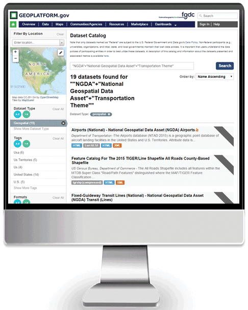 Geoplatform.gov NGDA query result. |
As a part of the FGDC efforts to implement geospatial portfolio management processes as defined in the Supplemental Guidance to OMB Circular A–16, an enormous amount of work was done across the FGDC community this year to ensure the registration of all NGDAs in the catalog used by Data.gov and the Geospatial Platform. Through this work, Action 1B.2 of the NGDA Management Plan was completed, and users of Geoplatform.gov can now discover and access NGDA data from across the FGDC partner community. This represents a major step forward in the accomplishment of its goals for improved management of the shared geospatial data portfolio. |
National Geospatial Advisory Committee—Collaborating for Results
Federal geospatial programs are highly dependent on effective relationships with partners and stakeholders from multiple sectors, including the private sector, academia, nonprofits, and all levels of government. One of the primary ways that the FGDC collaborates with its broad network of partners is through the National Geospatial Advisory Committee (NGAC). An action in the NSDI Strategic Plan's Objective 3.2 specifically mentions engagement with the NGAC.
Establishment of the National Geospatial Advisory Committee
The Department of the Interior (DOI) established the NGAC in 2008 as a means to improve coordination and governance of national geospatial activities. The NGAC includes a balanced membership representing a cross section of organizations involved in geospatial issues. The committee provides advice and recommendations to the FGDC and provides a forum to convey views representative of partners in the geospatial community.
The NGAC was created under the Federal Advisory Committee Act, which was enacted by Congress to ensure that advice provided to the executive branch by advisory committees, task forces, boards, and commissions will be both objective and accessible to the public. The NGAC functions solely as an advisory body.
The NGAC has been highly effective in providing thoughtful, considered advice on the management of Federal and national geospatial programs, the development of the National Spatial Data Infrastructure, and the implementation of key policy documents, including Office of Management and Budget Circular A–16. The Federal geospatial community has benefitted richly from the talent, expertise, and constructive advice provided by the NGAC.

June 2015 NGAC meeting.
Membership
Since the committee's inception in 2008, over 65 individuals have served as members of the NGAC. The NGAC members have come from a broad range of backgrounds and perspectives and have brought diverse viewpoints, experiences, and expertise to the committee's deliberations. Members have included geographic information system (GIS) managers for cities, counties, and Tribal governments; State GIOs and CIOs; academic and technical experts; nonprofit leaders; CEOs and executives of large firms and small businesses; and many others. The diverse background of the membership has been a valuable asset for the NGAC and has led to creative discussions and approaches to new and emerging geospatial issues and topics.
Committee members are selected to provide a balanced representation of the various perspectives and organizations involved in geospatial issues. The Secretary of the Interior appoints members to the committee, and they serve staggered 3-year terms. The two next rounds of appointments will take place in 2015 and 2016. The FGDC announces and publicizes calls for nomination for appointment to the committee, and encourages all interested parties to apply. Members serve without compensation, but are reimbursed for expenses while attending committee meetings.
NGAC Membership - September 2015 |
|
| Dr. Robert Austin, NGAC Chair City of Tampa, FL (retired) Ms. Julie Sweetkind-Singer, Vice Chair Stanford University Mr. Talbot Brooks Delta State University Dr. Keith Clarke University of California, Santa Barbara Mr. Steve Coast Telenav, Inc. Mr. Dan Cotter U.S. Department of Homeland Security Ms. Patricia Cummens Esri Mr. David DiSera RAMTeCH Corporation Mr. Steve Emanuel State of New Jersey Prof. Joanne Irene Gabrynowicz University of Mississippi Law School Mr. Matthew Gentile Deloitte Financial Advisory Services, LLP Mr. Bert Granberg State of Utah Mr. Frank Harjo Muscogee (Creek) Nation Mr. Jack Hild Hild Enterprises, LLC |
Mr. Michael Jones Wearality Corp. Mr. Jeff Lovin Woolpert, Inc. Mr. Jack Maguire Lexington County, SC (retired) Mr. Keith Masback U.S. Geospatial Intelligence Foundation Mr. Roger Mitchell MDA Information Systems, Inc. Mr. Kevin Pomfret Centre for Spatial Law and Policy Major General William N. Reddel III New Hampshire National Guard Dr. Douglas Richardson Association of American Geographers Mr. Anthony Spicci State of Missouri Mr. Gary Thompson State of North Carolina Dr. Harvey Thorleifson Minnesota Geological Survey Ms. Molly Vogt City of Gresham, OR Mr. Jason Warzinik Boone County, MO Mr. David Wyatt Eastern Band of Cherokee Indians |
 NGAC members, September 2015. |
|
NGAC Chairs |
|
 |
Ms. Anne Hale Miglarese Currently President and CEO of PlanetIQ Anne Hale Miglarese was the initial Chair of the NGAC, serving from 2008 to 2010. Ms. Miglarese developed the initial operating procedures and processes for the committee, including mission and vision statements, and a structure for meetings, subcommittees, and development of committee products. Ms. Miglarese provided the committee with an excellent foundation, organization, and collaborative spirit. During her term, the committee focused on developing clear goals and plans of action, and produced foundational products, including the NGAC Changing Landscape paper and Transition Recommendations paper. |
 |
Dr. David Cowen Professor Emeritus, University of South Carolina David Cowen was the second Chair of the NGAC, serving from 2011 to 2012. Dr. Cowen provided energetic and collaborative leadership for the committee, challenging the FGDC to make the best use of the NGAC members' time and talents. Under his leadership, the NGAC helped conceptualize the Geospatial Platform initiative, provided excellent feedback and recommendations on geospatial workforce development and parcel data, and produced best practices papers on intergovernmental data sharing and local government GIS programs. |
 |
Dr. Robert Austin ity of Tampa (retired) Robert Austin is the third Chair of the NGAC, serving from 2013 to the present. Dr. Austin has brought a wealth of experience to his role, having served in academia, in the private sector, and in local government. Under his leadership, the NGAC provided extensive input into the development of a new strategic plan for the NSDI, helping to set a path forward for the FGDC and its partners. Dr. Austin has skillfully guided the committee in providing input into key initiatives, such as the National Address Database and the 3D Elevation Program. He has also organized spotlight sessions to explore emerging topics, such as crowdsourced geospatial data and geospatial privacy. |
The Work of the National Geospatial Advisory Committee
The NGAC holds three to four public meetings each year. The public is invited to attend and offer comments at all committee meetings, which are announced by publication in the Federal Register at least 15 days before the meeting date. The NGAC reports to the Chair of the FGDC (the Secretary of the Interior or the Secretary's designee). The FGDC Executive Director serves as the Designated Federal Officer for the NGAC, the FGDC Office of the Secretariat provides staff support for the operations of the NGAC.
Each year, the FGDC provides guidance to the NGAC describing issues and study topics for consideration by the committee. The NGAC also offers input on potential study topics, promoting two-way communication on issues of common interest to the national geospatial community. The NGAC establishes subcommittees each year to address the topics in the annual guidance. Much of the NGAC's work is done in the subcommittees. The subcommittees develop draft papers and recommendations for consideration by the full committee. All final decisions are made by the full committee during public meetings. Generally, each NGAC member will serve on one subcommittee. Currently, the NGAC has the following subcommittees:
- NSDI Outreach and Communications
- Crowdsourced Geospatial Data
- Geospatial Privacy
- Landsat Advisory Group
- 3D Elevation Program
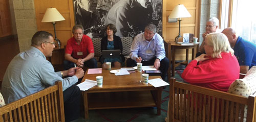
NGAC Subcommittee meetings.

September 2015 NGAC meeting.
Impacts
The establishment of the NGAC has resulted in more effective collaboration with external partners and has resulted in useful and constructive advice and recommendations on critical national geospatial topics. Key NGAC impacts and contributions include the following:
NSDI Strategic Plan. The NGAC played a critical role in the development of the 2014-2016 NSDI Strategic Plan. The strategic plan describes a shared national vision for the NSDI and includes a clear set of goals and objectives for the Federal role in achieving this vision. The NGAC provided extensive input and comment during the development of the plan. The plan, which was developed through extensive outreach and collaboration, provides a clear roadmap for the FGDC's activities over a 3-year period and provides guidance for Federal agencies and other stewards of geospatial information to maximize the plan's utility. Since the adoption of the plan, the NGAC has continued to provide valuable input and feedback on the implementation of the plan.
Geospatial Platform. The NGAC has provided extensive input into the conceptualization, development, and implementation of the Geospatial Platform initiative since its inception. This has included providing input and comment into foundational documents for the Platform, including the Platform value proposition, development roadmap, and business case. More recently, the NGAC has reviewed and provided real-time feedback on the latest revisions and enhancements to the Platform Web site. The NGAC has been highly supportive of the Geospatial Platform as a means for more effective collaboration between the Federal Government and partners in State, Tribal, and local governments.
National Address Database. The NGAC has provided ongoing input into the conceptualization of the proposal to develop a National Address Database. In 2012, the NGAC developed a white paper describing the need and justification for an address database. The paper was based on input from multiple parties, and the NGAC also brought together an expert panel to explore the options for creation of a national database. More recently, the NGAC developed a set of use cases further documenting the value and utility of the development of a National Address Database. The NGAC worked closely with representatives of the United States Census Bureau, the U.S. Department of Transportation, and other agencies to provide continuing feedback on the development of a National Address Database.
Multiagency, Intergovernmental Geospatial Data Initiatives. The NGAC has provided effective and timely input into a series of interagency data initiatives, encouraging the Federal Government to work with other levels of government and the private sector to develop comprehensive national-scale geospatial data initiatives that will provide economies of scale and result in high-quality, consistent data that will enable more effective decision making. Examples include the following:
- 3-D Elevation Program
- Transportation for the Nation
- Landsat Program
- National Land Parcel Data
- Imagery for the Nation
- National Height Modernization System
The NGAC has been highly effective in contributing to the policy framework that supports the objectives of the NSDI, and fostering productive relationships across sectors. The FGDC looks forward to continuing collaboration with the NGAC in communicating the value of geospatial information and tools to enable informed analysis, decision making, and management.
Additional information about the committee, including membership, research reports, and best practice documents, is available at www.fgdc.gov/ngac.
Crowdsourced Geospatial Data |
| The NGAC has played a vital role in identifying and exploring new and emerging issues. The committee has organized a series of panel discussions bringing experts, researchers, and practitioners together to explore emerging topics, discuss potential impacts to Federal agencies and stakeholders, and develop recommendations for action. Panel discussions have covered a number of topics, including geospatial workforce development, data sharing, parcel data, address data, geospatial privacy, and a highlight this year—the NGAC exploration crowdsourced geospatial data. Collaborating with FGDC agencies and other partners, the NGAC has examined and provided input on the emerging topic of crowdsourced geospatial data and citizen science. Crowdsourcing is a process of obtaining needed services, ideas, or content by soliciting contributions from a large group of people, and especially from an online community. Citizen science is a form of open science and innovation where members of the public participate in the scientific process to address real-world problems. The NGAC held a series of panel discussions with experts in crowdsourcing and citizen science to examine critical issues to consider in the development, management, and use of crowd-sourced geospatial data, including maintenance, validity, metadata, and workforce impacts. Participants in these panel discussions included Presidential Innovation Fellows, practitioners from several agencies, and industry leaders from organizations, including OpenStreetMap, timbr.io, and MapBox. The NGAC also collaborated with the FGDC and the Federal Community of Practice on Crowdsourcing and Citizen Science to share lessons learned and to develop best practices for designing, implementing, and evaluating crowdsourcing and citizen-science initiatives. The Community of Practice has developed a Federal practitioner toolkit that includes best practices, training, policies, guidance, and tools. NGAC members provided feedback on the toolkit Web site and developed a set of geospatially focused use cases for inclusion in the toolkit. The toolkit was rolled out at a White House event on September 30, 2015.  |
Fiscal Year 2015 Accomplishments—Achieving the NSDI Strategic Plan
The FGDC community is working collaboratively to implement the 2014–2016 NSDI Strategic Plan. The FGDC Executive Committee has the lead responsibility for overseeing and monitoring the implementation of the plan and has appointed designated Federal officials to serve as champions for the plan's objectives. The champions are responsible for overseeing the implementation of each objective and its supporting actions. The NSDI Strategic Plan includes 3 strategic goals, 9 objectives, and 29 actions. The objectives and actions are further divided by an implementation plan that includes more detailed tasks and performance metrics. The table in Appendix E provides a summary of these elements and the fiscal year 2015 implementation status. In summary, there were 36 tasks scheduled for FY2015—24 were reported as complete and 12 are reported as in progress. The fiscal year 2016 tasks are reported as on schedule.
The implementation of the strategic plan has resulted in multiple accomplishments that have enhanced shared services, improved access to geospatial data and services, and increased participation of the NSDI stakeholder community. Accomplishments in the following areas are described within this section, except for the NGAC (see Establishment of hte National Geospatial Advisory Committee)
- Geospatial Interoperability Reference Architecture (Objective 1.1)
- Geospatial Platform (Objective 1.2)
- GeoCloud (Objective 1.3)
- National Geospatial Data Assets Management Plan and Portfolio Management (Objective 2.1)
- Standards, including metadata (Objective 3.1)
- National Geospatial Advisory Committee (Objective 3.2)
- Geospatial Privacy (Objective 3.2)
- NSDI Communication and Outreach Strategy (Object 3.3)
- International Activities (Objective 3.3)
GIRA providing a Roadmap for Information Sharing
The Geospatial Interoperable Reference Architecture (GIRA) provides a framework for the management, design, and development of new or newly aligned existing geospatial system/solution investments. It recommends guidance considerations in the areas of governance, business, data, applications/services, infrastructure, standards and security, and performance measures for validating and reporting results. The GIRA is intended to support implementation of the NSDI by providing a practical roadmap to increase government geospatial information sharing through interoperable capabilities that result in reduced operational costs within and across an organization's mission systems. It documents geospatial and architecture policy alignment, references authoritative practices, and provides practical guidance, including templates, charters, exchange agreements, baseline requirements matrices, architecture artifacts, and tools. The GIRA is aligned with current Federal policy, principles, and practices for Enterprise Architecture and further adds to the authoritative body of knowledge of geospatial architecture documentation that supports the civil, defense, and intelligence communities. It is an unclassified document aimed at an audience consisting of executive leaders, program managers, and solution architects across Federal, State, Tribal, territorial and local governments, and private sector stakeholders.
The GIRA is a joint effort between the Program Manager-Information Sharing Environment (PM-ISE) and the FGDC and supports NSDI Strategic Plan Objective 1.1. The Department of Homeland Security (DHS) serves as the lead for an interagency interoperability working group. The DOI serves as the lead for the Geospatial Platform. The National Geospatial-Intelligence Agency (NGA) serves as the lead for the National System for Geospatial Intelligence. The U.S. Department of Commerce and the National Oceanic and Atmospheric Administration (NOAA) contributed their requisite experience and authority.
Fiscal year 2015 accomplishments of the GIRA include:
- The PM-ISE issuance of the GIRA as a component of the Information and Interoperability (I2F) framework. (See below.)
- The FGDC endorsement of the GIRA, following an interagency review of the GIRA, and it received nearly 150 comments from the FGDC Office of the Secretariat, the Census Bureau, DOI, the National Geospatial-Intelligence Agency (NGA), NOAA, the U.S. Department of Energy (DOE), the U.S. Fish and Wildlife Service (FWS), the U.S. Geological Survey (USGS), and DHS. The comments were very positive, such as the following:
- 'It's very well put together, Fed-focused, instructional in tone, and very thorough as well.'
- 'It's a how-to-do framework manual.'
- Other positive feedback for the GIRA, reinforcing its value to the geospatial community, came from the National States Geographic Information Council (NSGIC) and the American Council for Technology–Industry Advisory Council (ACT–IAC). Specific testimonial also comes from standards development organizations and geospatial associations, including the Open Geospatial Consortium (OGC) and the National Alliance for Public Safety (NAPSG) Foundation.
- The FGDC Steering Committee approved the establishment of an online, collaboration resource for the GIRA within the Geospatial Platform to provide ongoing enhancement and sustainment of the GIRA by the stakeholder community and to improve discovery, access, and contribution to the GIRA's body of knowledge.
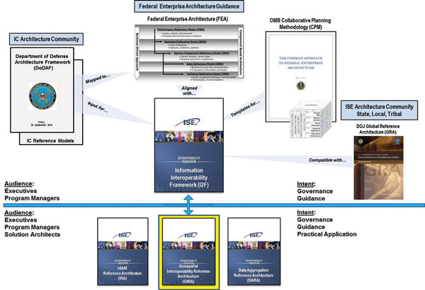
GIRA alignment with Federal Enterprise Architecture.
Sharing Information via the Geospatial Platform
![]()
The Geospatial Platform is a cornerstone initiative of the National Spatial Data Infrastructure as outlined in the NSDI Strategic Plan. The FGDC is making progress towards establishing the Geospatial Platform as the Federal geospatial data, services, and applications Web-based environment which supports meeting Objective 1.2 of the Plan. This effort is a component of the Administration's Information Technology (IT) Shared Services initiative and is designed to help agencies more effectively produce and share their geospatial data, services, and applications across the Government and with external partners.
Fiscal Year 2015 represented the first full year of operations with the support of the new, primary technical development contractor team. This important milestone represents completion of Action 1.2.3 of the NDSI Strategic Plan, and the new team has worked very hard to deliver a number of new capabilities and benefits to the FGDC community. New features of the Geospatial Platform released in fiscal year 2015 included the following:
- A completely redesigned Web site and user experience. Taking advantage of feedback from the user community, the Geoplatform.gov Web site was redesigned to help users search data and to expand the use and understanding of national geospatial resources.
- The release of the Geospatial Platform Web Map Viewer and Gallery. Users of the Geospatial Platform can now interactively browse geospatial data assets to build custom maps, upload their own data to maps, and to share maps with others. The Web Map Viewer features indicators of Web service quality and availability for each of the layers made available through Geoplatform.gov, allowing users to get a visualization of the geospatial layers. Once saved, these maps can be published through an advanced Map Gallery capability and shared within Communities of Geoplatform.gov or embedded on other Web pages across the Internet.
- The first version of the National Geospatial Data Asset Lifecycle Maturity Dashboard. In support of the National Geospatial Data Asset Management Plan's objective to establish online planning and reporting tools, the Geospatial Platform team developed the NGDA Dataset Lifecycle Maturity Assessment Survey and dashboard. These tools will assist NGDA Dataset Managers in the evaluation of each dataset's maturity based on the Geospatial Data Lifecycle assessment process described in the Supplemental Guidance to OMB Circular A–16.
GeoCloud Advancing Cloud Services
In 2015, the FGDC's GeoCloud initiative sponsored the operational deployment of key public-facing geospatial Web services and engaged several new projects as part of the shared-services strategy to advance the Geospatial Platform, which supports expanding the use of cloud computing (NSDI Strategic Plan Objective 1.3). The GeoCloud served as an incubator for projects that provided data, information, applications, tools, and services related to national efforts in biodiversity, climate, public health, environmental health, housing affordability, water use and availability, social, economic, and environmental subject areas. These research and development projects tested local, regional, and national geospatial data collection, processing, distribution, Web mapping, map viewing, data catalog, and other geospatial services to support social, economic, and environmental understanding, and decision making. The successful launch of these new geospatial capabilities will provide the Nation with new geospatial knowledge and tools for understanding and decision making. For more information, see www.fgdc.gov/initiatives/geoplatform/geocloud. The GeoCloud highlights include the following:
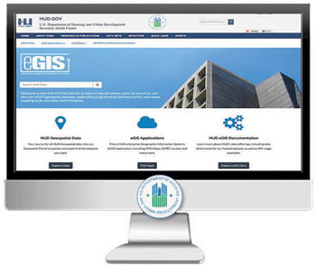
- Housing and Urban Development Geospatial Storefront (GeoPortal) Prototype. The Housing and Urban Development (HUD) developed a cloud-based portal for search and discovery of HUD's geospatial applications, services, and datasets. The Storefront unifies public access to HUD's portfolio of applications and geospatial data resources, including HUD's NGDA Datasets. The initial build of the Storefront is focused on HUD's core geospatial datasets, but will include all of HUD's published geospatial data. Following iterations will also include expanded documentation, including developer guidance for the application programming interfaces (API), online training resources for HUD mapping applications, and tighter coordination with Data.gov and Geoplatform.gov.
GIRA alignment with Federal Enterprise Architecture. - Department of Energy NEPAnode Portal Prototype. The NEPAnode is a collection of services and tools made available to Federal staff and contractors working to implement the National Environmental Policy Act of 1969 (NEPA) and other related environmental reviews and permitting processes. NEPAnode's core mission is to enable nongeospatial professionals with advanced geospatial place-based tools for data gathering, sharing, monitoring, and reporting. NEPAnode provides a suite of geospatial-enriched shared Web services, software, and GIS tools in developing a place-based visual synthesis, analysis, and reporting capability that assists in reporting and understanding environmental assessments and permitting.

DOE's NEPAnode Portal Prototype.
Implementing the National Geospatial Data Asset Management Plan
The NGDA Management Plan, approved by the FGDC Steering Committee in March 2014, outlines a vision to develop an NSDI Portfolio consisting of a core set of NGDAs that is sufficiently complete, current, and accessible to support the critical business and mission requirements of the Federal Government and its partners and stakeholders. In order to realize this vision, the plan encompasses a series of phased actions and milestones to implement a systematic and efficient A–16 NGDA Portfolio management process. The process aims to support and optimize investments in Federal geospatial assets for effective sharing, collaboration, and use of core geospatial data in an environment that supports efficient and effective decision making.
The A–16 NGDA Portfolio management process has been defined in the Office of Management and Budget (OMB) Circular A–16 Supplemental Guidance (November 2010). Portfolio management is described 'as the coordination and management of Federal geospatial data assets and investments to most efficiently support national priorities and government missions. Portfolio management applies consistent management approaches that help increase the quality of data through use of best practices and documentation in a manner that reduces duplication and cost, provides greater accessibility, and supports shared services across the Federal Government.' In addition, the NGDA Management Plan supports the outcomes noted in Objective 2.1 of the NSDI Strategic Plan, and advances Goal 2 to ensure accountability and effective development and management of Federal geospatial resources.
A total of 27 actions, implemented over 3 fiscal years (2014–2016), are described in the NGDA Management Plan. These actions are divided into two main phases: (1) preparing the management and reporting framework for inventorying and qualifying the contents of the Federal Geospatial Portfolio and (2) executing the portfolio management process. Five 2014 accomplishments should be noted briefly:
- Federal staff has been identified to fill the Theme Lead and Dataset Manager roles, and they continue to be a critical factor in plan implementation.
- 179 National Geospatial Data Assets have been officially identified.
- The NGDA Theme Lead collaboration community provides access to many resources that support Theme implementation through Geoplatform.gov.
- Each Theme has a public Web site on Geoplatform.gov with information about their associated NGDA Datasets, stakeholder communities, and other resources.
- Since early 2014, the Theme Leads and Dataset Managers have participated in regular conference calls and face-to-face meetings, when possible, to discuss ideas and collaborate on plan activities.
The 2014 accomplishments contributed to an additional five actions being completed in fiscal year 2015. So far, a total of 10 of the 27 actions listed in the NGDA Management Plan have been completed. The 2015 actions focused on preparing the management and reporting framework.
Fiscal Year 2015 NGDA Management Plan Actions Completed: |
|---|
| Action 1B.2: Register Baseline NGDA Datasets and Services Metadata on the Geoplatform.gov/Data.gov Catalog with Appropriate NGDA and Theme 'tags' Action 1B.3: Develop an Approval Process for Nomination/Removal of NGDA Datasets within the A–16 NGDA Portfolio Action 1C.2: Develop A–16 Theme Collaboration Community for Templates and Tools on Geoplatform.gov Action 1D.1: Develop NGDA Dataset Maturity Annual Assessment Survey and Tool Action 1D.4: Develop Support Theme Strategic Plan Template |
Action 1B.2: Register Baseline NGDA Datasets and Services Metadata on the Geoplatform.gov/Data.gov Catalog with Appropriate NGDA and Theme 'tags'
In July 2015, the metadata for the 179 baseline NGDA Datasets were fully registered as NGDAs in the catalog that serves Data.gov and Geoplatform.gov. The NGDA metadata guidance released in early 2015 developed by the NGDA Metadata Focus Group contributed to the successful registration of many of these NGDA Datasets. Overall, the completion of this action supports the improved access to data that supports Federal agency, partner, and stakeholder missions, and the ability to identify data partnering opportunities through the Geoplatform.gov Marketplace. In addition, it meets goals in the Digital Government Strategy and the Open Data Policy. The list of NGDA Datasets is available via A–16 NGDA Theme Community (cms.geoplatform.gov/A-16-NGDA-Theme-Community). As part of the registration process, the original 189 NGDA Datasets identified in July 2014 were reduced to 179 official NGDA Datasets as of September 2015. The changes to the NGDA inventory were caused by combining related datasets into single collections, separating NGDAs that had been combined into single NGDAs, and removing datasets that were duplicates or that did not meet the definition of an NGDA.
| Changes to NGDA Dataset Inventory | |
|---|---|
| Number of NGDAs FY2014 | 189 |
| Added | 5 |
| Removed | 12 |
| Combined | 16 combined into 6 |
| Separated | 3 separated into 10 |
| Number of NGDAs FY2015 | 179 |
Action 1B.3: Develop an Approval Process for Nomination/Removal of NGDA Datasets within the A–16 NGDA Portfolio
The process for the addition, change, or removal of datasets from the NGDA inventory was vetted and approved by the Dataset Managers, Theme Leads, and FGDC Coordination Group (CG). OMB Circular A–16 Supplemental Guidance requires that geospatial datasets be routinely inventoried and recommended for inclusion in or removal from the A–16 NGDA Portfolio. The inventory is a collaborative process that provides transparent A–16 NGDA Portfolio management that will promote targeted resources applied to geospatial datasets deemed critical for supporting Federal agency, partner, and stakeholder missions.
Action 1C.2: Develop A–16 Theme Collaboration Community for Templates and Tools on Geoplatform.gov
Each of the 16 NGDA Themes now have a Geoplatform.gov presence that can be managed by the Theme Leads. These managed A–16 NGDA Theme collaboration communities are designed to increase exposure of NGDA Datasets; increase collaboration, partnerships, and participation in NGDA Theme development and requirements; and increase use of the Theme's datasets. The A–16 NGDA Theme communities are available at cms.geoplatform.gov/A-16-NGDA-Theme-Community.
Action 1D.1: Develop NGDA Dataset Maturity Annual Assessment Survey and Tool
To support the geospatial data lifecycle assessment process, OMB Circular A–16 Supplemental Guidance requires that NGDA Dataset Managers regularly assess the maturity of their datasets. This year, the NGDA Dataset Lifecycle Maturity Assessment (LMA) survey was completed and approved. A tool for completing the initial baseline assessments was made available to NGDA Dataset Managers. The outcome of this action will provide inputs to other key actions within the A–16 NGDA Portfolio management process. For more information, see cms.geoplatform.gov/A-16-NGDA-Theme-Community/LMA. The result of this action feeds into Action 2A.1, which calls for the Dataset Managers to complete the baseline NGDA LMA. By the end of September 2015, 70% of the LMA assessments were completed.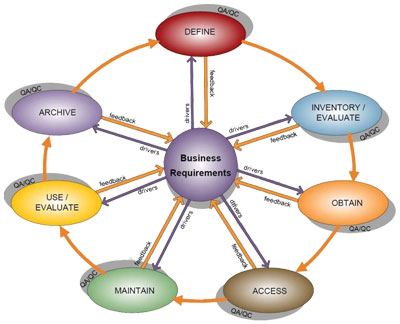
OMB Circular A–16 Supplemental Guidance - lifecycle stages.
Action 1D.4: Develop NGDA Strategic Theme Plan Template
The NGDA Theme Leads, along with input from the FGDC, developed the template for Theme strategic plans. The purpose of the template is to provide a consistent approach to measuring progress and to facilitate the FGDC Steering Committee's ability to manage the A–16 NGDA Portfolio. The template is available at cms.geoplatform.gov/A-16-NGDA-Theme-Community.
NGDA Management Plan Actions in Progress
In fiscal year 2015, an interagency team was formed to support completion of Action 1E.1: Review/Revise the Definition of Geospatial Investment and Budget Reporting Codes. The team members from the Census Bureau, DHS, DOI, EPA, the General Services Agency (GSA), NGA, and the U.S. Department of Agriculture (USDA) met regularly and presented to the FGDC Executive Committee a revised geospatial investment definitions document and suggested an implementation process. The FGDC Executive Committee began the process of coming to consensus on geospatial budget reporting codes. The goal is to improve reporting on geospatial data investments that will enhance budget planning and execution.
At the July and August Theme Lead meetings, the Theme Maturity Assessment was discussed, and efforts to develop this reporting mechanism, which is the next step in building the framework for portfolio management, will be a focus in the coming year.
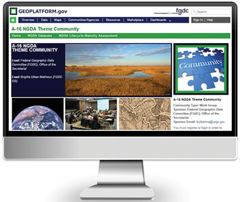
A–16 NGDA Theme Community Web site.
Advancing NGDA Portfolio Management
The A–16 NGDA Portfolio is organized by NGDA Themes made up of one or more associated NGDA Datasets. Datasets support the critical business and mission requirements of the Federal Government, as well as its partners and stakeholders. Currently, 16 NGDA Themes and 179 NGDA Datasets make up the portfolio; a list is available on the A–16 NGDA Theme Community Web site (cms.geoplatform.gov/A-16-NGDA-Theme-Community). The Themes are managed by Theme Leads who provide cross-agency leadership and coordination. The Datasets are managed by Dataset Managers who provide coordination for the NGDA Datasets at a national level.
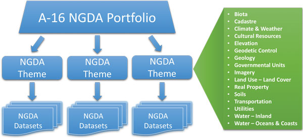
Structure of the A–16 NGDA Portfolio and list of NGDA Themes.
In fiscal year 2015, the NGDA Theme Leads and Dataset Managers worked together to fulfill the responsibilities identified for them in the NGDA Management Plan. These included the following:
- Registering the baseline 179 NGDA Datasets in the catalog that serves both Data.gov and Geoplatform.gov.
- Developing (1) an approval process for nomination and removal of NGDA Datasets within the portfolio, (2) the NGDA Dataset Maturity Annual Assessment Survey, and (3) the Theme strategic plan template.
- Focusing at the end of the fiscal year to complete the baseline NGDA Dataset Lifecycle Maturity Assessments that will form the foundation for informed portfolio reporting.
In addition, there were numerous accomplishments within the Themes as well.
Biota Theme. The Theme Lead pursued discussions with colleagues from the U.S. Forest Service (USFS) and the U.S. Geological Survey (USGS) to include additional datasets in the NGDA inventory that are of national significance and meet the NGDA criteria.
Cadastre Theme. The Bureau of Land Management (BLM) facilitated and (or) completed the standardization of the Public Land Survey System (PLSS) Dataset for 29 of the 30 PLSS States, with Oklahoma still pending but scheduled for completion in fiscal year 2016. These are initial standardized datasets that are continuing to be updated with added control, partnership activities, and new surveys.
Cultural Resources Theme. The Theme Lead, who is from the National Park Service (NPS), managed the Lifecycle Maturity Assessments for the Theme's NGDAs and opened a discussion with DHS and the Homeland Infrastructure Foundation-Level (HIFLD) Subcommittee to explore replacing the National Monument/Icons NGDA, which is a proprietary dataset, with the National Register of Historic Places NGDA. The National Register dataset may contain more extensive, detailed, and up-to-date information, which would benefit the HIFLD data use.
To support the NGDA Datasets within the Theme, progress was made on creating a cultural resource spatial data transfer standard. The work included surveying State Historic Preservation Offices for their data exchange needs and practices, and then incorporating their responses into the structure of the draft standard.
Elevation Theme. To further the integration of and coordination between the topographic and bathymetric interests of the NGDA Elevation Theme, the 3D Elevation Program and the Interagency Working Group on Ocean and Coastal Mapping formally proposed the creation of the 3D Nation Elevation Subcommittee, consisting of these two working groups as a recognized FGDC subcommittee. The goal of the 3D Nation Elevation Subcommittee is to continually improve the national elevation mapping foundation by coordinating the topographic, coastal, and bathymetric mapping activities across the Federal Government.
Geodetic Control Theme. The NGDA Dataset Managers for the Geodetic Control Theme completed the NGDA Lifecycle Maturity Assessments for the Theme's datasets.
At the Federal Geodetic Control Subcommittee semiannual meeting, the Theme Lead, who is from NOAA's National Geodetic Survey (NGS), discussed the Geodetic Control Theme in great detail so that the subcommittee members understand what steps are currently being taken. The Theme Lead also continued to highlight the importance of working with partners to enhance products, services, and common goals. Many of these talks highlight the benefits of placing common datasets under a 'Theme' and how the efforts will reduce duplication, enhance accessibility, provide greater transparency, and broaden the knowledge base on themed data.
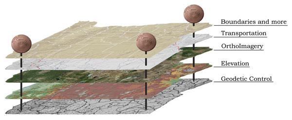
Geodetic Control is the foundational layer that keeps all other NGDA Themes spatially aligned to each other.
Governmental Units, and Administrative and Statistical Boundaries Theme. Ensuring the quality of boundaries is an essential element of the Census Bureau's role as the lead for the Governmental Units, and Administrative and Statistical Boundaries Theme. The FGDC National Boundaries Group collaborated with the Cadastral Subcommittee to identify where boundaries could be improved using cadastral features. The Census Bureau built upon this multiagency effort to establish the Boundary Quality Assessment and Reconciliation Project (BQARP). The BQARP is a one-time operation to assess the boundaries with a goal to establish quality and set a quality flag on each boundary segment. The Census Bureau reconciles the legal documents (or descriptions) against the Census Bureau spatial boundaries data and cadastral data, such as Public Land Survey System (PLSS) and parcel data. This reconciliation is a joint effort between the State or county government and the Census Bureau, as well as other Federal agencies.
Imagery Theme. To enhance Imagery Theme stakeholder communications, a community for the National Digital Orthoimagery Program (NDOP) was created on the Geospatial Platform (cms.geoplatform.gov/a16imagery/NDOP). This is a valuable tool for coordination of efforts and resources. The Imagery Theme Co-Leads from USDA and DOI organized a specialized training session on the Lifecycle Maturity Assessment survey to assist the Theme's Dataset Managers as they completed the survey.
Land Use Land Cover Theme. In February 2015, the Multi-Resolution Land Characteristics (MRLC) consortium released the latest edition of the NGDA Alaska National Land Cover Database (NLCD). It is the most comprehensive look at land-surface conditions of the State and shows the extent of land cover types from forests to urban areas. Derived from carefully calibrated observations of Landsat satellites in 2011, the dataset identifies current land cover and those areas that have changed since the year 2001. The consortium is a group of Federal agencies who coordinate and generate consistent and relevant land cover information at the national scale for a wide variety of environmental, land-management, and modeling applications. For more information, see www.mrlc.gov
Real Property Theme. The Real Property Theme continued to improve standardizing geolocation data collection requirements for reporting to the Federal Real Property Profile (FRPP), the Federal Government-wide real property asset reporting system. The continued improvements to collect more accurate and standardized location data allows for complex analysis, modeling, planning, and asset management. The data-collection requirements for the fiscal year 2015 FRPP asset reporting cycle included improving address accuracy and requiring that latitude and longitude information be submitted using a common coordinate reference system. In addition, the codes for cities have been linked to the Geographic Names Information System (GNIS) to allow new reporting codes to be based on this authoritative data source.
Soils Theme. The annual update of the NGDA Soil Survey Geographic Database (SSURGO) was completed and is available to land use decision makers, researchers, and modelers. Every 10 years, the NGDA Major Land Resource Areas (MLRA) Dataset is updated through a significant effort involving input from numerous Federal and university partners. In 2015, the planning and coordinating work was ongoing to meet the scheduled 2016 completion. The MLRA Dataset contains groupings of physiography, geology, climate, water, soils, biological resources, and land use as described in USDA Agricultural Handbook 296 (2006).
Transportation Theme. The U.S. Department of Transportation (USDOT) completed the strategic plan for the Transportation Theme in August 2015. The plan was shared with the Federal Geographic Data Committee and is being used to guide other Themes. The Theme Lead worked with Dataset Managers from USDOT, U.S. Army Corps of Engineers (USACE), and the Census Bureau to ensure the timely completion of each Lifecycle Maturity Assessment. The Theme lead presented at the HIFLD Subcommittee in June on the Transportation NGDAs and status of the Rail Network.
Water - Inland Theme. The USGS and FWS Co-Leads for the Theme provided an assessment of the Water - Inland Theme at the June 2015 FGDC Steering Committee meeting. The USGS has begun development of the High-Resolution National Hydrography Dataset Plus (NHD+HR), modeled after the highly successful 1:100,000-scale NHDPlus, which is an NGDA. The NHD+HR will provide a robust set of network attributes and routing capability for a much more detailed network, while adding scalability, to provide a unified geospatial framework of reference for water data.
The FWS has continued the development of the National Wetlands Inventory (NWI) Version 2 (Surface Waters and Wetlands Inventory) that includes the never-before served legacy NWI linear data with augmentation from the National Hydrography Dataset (NHD) to complete segmented connections. This newly derived NGDA depicts all surface-water and wetland features in a single polygonal feature class and applies the second edition of the FGDC classification of Wetlands and Deepwater Habitats of the United States (FGDC-STD-004-2013) to provide consistent ecological descriptors.
National Water Information System (NWIS) drainage areas were included in an approved revision of the Watershed Boundary Dataset (WBD) data model. This included completing all eight-digit hydrologic unit boundaries and hydrography across the United States-Canadian border, including Alaska.
Water - Oceans and Coasts Theme. The Theme contains a wide variety of data types, such as boundaries, nautical charts, and sea levels, each with unique missions, requirements, and user bases. In fiscal year 2015, the Water - Oceans and Coasts Theme Lead continued to work closely with the Marine and Coastal Spatial Data Subcommittee and other related FGDC subcommittees and working groups. In addition, coordination was initiated with the Interagency Working Group on Ocean and Coastal Mapping. The outreach to groups with shared interests in the Theme will help agencies optimize resources for future efforts. For further information, please see the A–16 NGDA Theme Community (cms.geoplatform.gov/A-16-NGDA-Theme-Community).
NOAA Support for Portfolio Management |
| The NOAA has fully engaged in their broad range of responsibilities within the NGDA portfolio management process, including leadership of four NGDA Themes and management of 25 NGDAs. To ensure NOAA meets all portfolio management requirements, an agency coordinator was designated who reports to the NOAA Geospatial Information Officer with support from NOAA's Chief Information Officer. The coordinator communicates regularly with NOAA Theme Leads and Dataset Managers and reports activities to NOAA management. In fiscal year 2015, some activities included creation of an internal Web site for the agencies and their A–16 activities, a series of conference calls to discuss the baseline NGDA Dataset LMA, creation of a document to support LMA responses, sending reminders to staff about upcoming deadlines, and technical assistance. The coordinator also reached out to the Dataset Managers from other agencies that are part of NOAA-led Themes. Coordination within NOAA has allowed the agency to provide consolidated feedback on portfolio management issues and has contributed to successful implementation of several key NGDA Management Plan actions. |
Maintaining and Endorsing Standards
The FGDC continued its leadership and participation in development and coordination of national and international standards applicable to the geospatial community that help support Objective 3.1 of the NSDI Strategic Plan. Also noteworthy, February 2015 marked the fourth anniversary of the monthly standards update. Standards updates provide status of FGDC, OGC, the InterNational Committee for Information Technology Standards (INCITS) L1/ISO TC 211, Geospatial Intelligence Standards Working Group (GWG), and other standardization activities each month. There are over 300 standards tracked in the standards update log. The log has been maintained continuously since February 2011. In 2015, the FGDC endorsed the following five standards:
- Aeronautical Information Exchange Model (AIXM) 5.1
- ISO/IEC 15444-1:2004 Technical Corrigenda 1:2007 and 2:2008 JPEG 2000
- Open Geospatial Consortium (OGC) GeoPackage 1.0
- Geopolitical Entities, Names, and Codes (GENC) Standard Edition 2
- GeoRSS-Simple and GeoRSS-GML
In keeping with OMB Circular A–119 (www.whitehouse.gov/omb/circulars_a119), the FGDC adopted the following voluntary consensus standards in lieu of Government-unique standards:
Aeronautical Information Exchange Model (AIXM) 5.1 is a standard exchange format containing hundreds of entities, data types, and relationships used to represent aeronautical data. It is based on International Civil Aviation Organization (ICAO) standards and includes recommended practices and industry standards requirements for digital data exchange and GIS capability. It provides a mechanism to exchange information applicable to aerodromes (airports), heliports, routes, navigation aids, fixes, instrument approach procedures, instrument departures, standard terminal arrival routes, organizations, units, services, obstacles, and airspace. AIXM 5.1 was initially developed by the U.S. Federal Aviation Administration (FAA) and the European Organisation for the Safety of Air Navigation (EUROCONTROL) with support from the international community.
ISO/IEC 15444-1:2004 Technical Corrigenda 1:2007 and 2:2008 JPEG 2000 serve as errata for ISO/IEC 15444-1:2014, Information technology-JPEG 2000 image coding system: Core coding system. The FGDC previously endorsed ISO/IEC 15444-1:2014. ISO/IEC 15444-1:2004 defines a set of lossless (bit-preserving) and lossy compression methods for coding bilevel, continuous-tone gray-scale, palletized color, or continuous-tone color digital still images. It specifies decoding processes for converting compressed image data to reconstructed image data, a code-stream syntax containing information for interpreting the compressed image data, and a file format. It provides guidance on encoding processes for converting source image data to compressed image data and implementing these processes. Technical Corrigendum 1:2007 is a change notice for Annex I of ISO/IEC 15444-1:2004, while Technical Corrigendum 2:2008 provides clarification on determining maximum file size in Table A.46 of ISO/IEC 15444-1:2004.
Open Geospatial Consortium (OGC) GeoPackage 1.0 defines GeoPackages for exchange and GeoPackage SQLite Extensions for direct use of vector geospatial features and (or) tile matrix sets of Earth images and raster maps at various scales. Direct use is the ability to access and update data in a 'native' storage format without intermediate format translations. This environment guarantees data model and dataset integrity and identical access and update results in response to identical requests from different client applications. GeoPackages are interoperable across all enterprise and personal computing environments, and they are particularly useful on mobile devices like cell phones and tablets.
Geopolitical Entities, Names, and Codes (GENC) Standard, Edition 2.0 comprises the U.S. Government implementations of ISO 3166-1, Codes for the representation of names of countries and their subdivisions - Part 1: Country codes, and ISO 3166-2, Codes for the representation of names of countries and their subdivisions - Part 2: Country subdivision code. Direct use of ISO 3166 standard conflicts with U.S. Public Law 80-242 (1947), which requires the U.S. Federal Government to use geographic names that have been approved by the U.S. Board on Geographic Names (BGN). ISO 3166 contains country and subdivision names from the United Nations, which occasionally vary from those approved by the BGN. The GENC Standard Edition 2.0 addresses U.S. Government requirements for restrictions in recognition of the national sovereignty of a country and identification and recognition of geopolitical entities not included in ISO 3166.
The FGDC previously endorsed GENC Standard 1.0. GENC Standard 2.0 supersedes GENC Standard 1.0. The GENC Standard Edition 2 expands on Edition 1 with the formal establishment of administrative subdivision code content in the GENC Registry. The NGA hosts the GENC Registry (nsgreg.nga.mil/genc) as an online, dynamic information resource, in which content is structured in accordance with the GENC Standard information model. The GENC Registry is the single authoritative source for geopolitical entities (and administrative subdivisions), names, and codes.
GeoRSS-Simple and GeoRSS-GML are two encodings of GeoRSS. GeoRSS is a standardized way to encode location in RSS and Atom feeds. It allows users to perform geographic searches on feeds or to map information found in feeds. GeoRSS makes it possible to search with all sorts of geographic criteria. Its location content consists of geometries (including geographic points, lines, and polygons of interest) and related feature descriptions. GeoRSS feeds are designed to be consumed by geographic software, such as map generators. GeoRSS promotes interoperability and 'upward compatibility' across encodings through a common information model.
GeoRSS-Simple is a very lightweight format that developers and users can add to their existing feeds quickly and easily. It supports basic geometries (point, line, box, and polygon) and covers the typical use cases when encoding locations. GeoRSS GML is a formal GML Application Profile that supports a greater range of features, notably coordinate reference systems other than WGS-84 latitude/longitude.
The FGDC supports the Open Geospatial Consortium, Inc. (OGC) via the Global Earth Observations System of System (GEOSS) Architecture Implementation Pilot (AIP) that is developing and deploying new process and infrastructure components for the GEOSS Common Infrastructure (GCI) and the broader GEOSS architecture. This year Phase 8 of AIP builds upon the foundation laid down by Phase 7 which developed and deployed easy-to-use online (Web and Mobile) applications that demonstrate the value of standards-based access to Earth observation data and services registered with GEOSS. In order to achieve the AIP-8 goals weekly 'deep-dives' were organized and recorded. These were one hour in-depth technological sessions on specific standards-based technology. For more information please see www.ogcnetwork.net/AIpilot.
Metadata Supports Geoplatform.gov and National Geospatial Data Asset Initiatives
As the foundation for data discovery and use, metadata continued to a play a key role across FGDC-related initiatives.
The NGDA Metadata Focus Group published the NGDA Metadata Guidelines report that includes detailed information about metadata content that makes data discoverable as an NGDA Dataset on the Data.gov and Geoplatform.gov catalog. Using these guidelines, the NGDA Theme Leads and Dataset Managers were able to incorporate the content requirements into existing and new metadata records. This effort enabled all NGDA Datasets to be successfully registered this year and made available through the Geoplatform.gov Theme Community Web site (cms.geoplatform.gov/A-16-NGDA-Theme-Community) and the Data.gov system. The Focus Group was an interagency team that included the FGDC Office of the Secretariat and NGDA Theme Leads and staff from the Census Bureau, DOI, EPA, GSA, NOAA, USDOT, and USGS.
The NGDA metadata efforts led to additional coordination between the geospatial community and Data.gov to facilitate meeting Open Data Policy requirements and increase accessibility of geospatial metadata and enhance the data publication workflow. Given the variety of programs and standards supported by Data.gov, it is a challenge to process, validate, and present information in a consistent manner. The FGDC and Data.gov hosted a joint meeting in November 2014 with representatives from the FGDC Office of the Secretariat, the Census Bureau, DOI, EPA, GSA, the National Aeronautics and Space Administration (NASA), NOAA, OMB, USACE, and USGS. As a result, two interagency working groups were established.
The Crosswalk Working Group started with the metadata crosswalk previously developed to support A–16, Project Open Data (POD) v1.0, and Data.gov efforts. The crosswalk was refined to identify core content between existing geospatial metadata standards (Content Standard for Digital Geospatial Metadata (CSDGM) and ISO 19115) and the POD v1.1 schema. The updated crosswalk was published on the POD GitHub site in January 2015 as a resource for the geospatial community to continue meeting these policies and directives.
The Harvesting and Validation Working Group has identified challenges, determined metadata-related issues, and developed recommendations for improving the publication process and error reporting so that more geospatial metadata records can be included in the Data.gov and Geoplatform.gov catalog. The recommendations were based on simplifying the process and focusing on the core metadata content identified by the earlier crosswalk effort. Coordination on implementation continues.
Geospatial data technologies, concepts, and supporting standards constantly evolve. To support the community in navigating these changes, the Metadata Program continued education and outreach efforts.
The ISO Geospatial Metadata Implementation Forum continued in 2015. The purpose of the Forum is for the FGDC Metadata Working Group and other NSDI stakeholders to present and discuss ISO geospatial metadata standards and implementation efforts through shared experiences and resources. This year, the Forum included speakers from Federal, State, local, and provincial governments; academia; and the private sector. The presentations included 'Building a State and Local Government Metadata Profile,' 'Transforming CSDGM Metadata to ISO,' 'Creating Geospatial Metadata for Project Open Data,' 'ISO 19115-3 XML Schema, State and Provincial ISO Implementation Efforts,' and 'Metadata Tools and Special Applications.' Sessions are held on a monthly basis and all materials are available through the FGDC Web site.
The ISO Geospatial Metadata Editors Registry was released after piloting the online application with software developers and individuals providing software user reviews. Several ISO metadata editor developers have provided information to the Registry and have been able to easily update and modify their information. The Registry includes features of the editor, its functionality, supported standards, and points of contact. User reviews provided by FGDC Metadata Working Group members describe additional aspects of the tools from an implementation perspective. This resource is available on the FGDC Web site for the NSDI stakeholder community to identify and compare relevant ISO metadata editors that meet their requirements (www.fgdc.gov/metadata/iso-metadata-editor-review-v2).
FGDC Metadata Web site improvements continued and development focused on creating informative content that can serve as educational material. Coordination with the broader standards community continued with active participation in INCITS L1 Geographic Information Systems Technical Committee, Open Geospatial Consortium Technical Committee, and the FGDC Standards Working Group.
Collectively, the metadata efforts support the following NSDI Strategic Plan objectives to:
- Develop geospatial interoperability reference architecture.
- Establish the Geospatial Platform as the Federal geospatial data, services, and applications Web-based service environment.
- Advance the portfolio management process for National Geospatial Data Assets.
- Lead and participate in the development and coordination of national and international standards applicable to the geospatial community.
| Feature | GeoNetwork OpenSource | CatMDEdit V.6.0 | Esri Geoportal Server |
|---|---|---|---|
| View Full Record | View Full Record | View Full Record | |
| Geospatial Metadata content Standards Supported | |||
| ISO 19115:2003 - Metadata |
full | full | full |
| ISO 19115-2 - Gridded Imagery Extension |
full | none | full |
| ISO 19110 - Feature Catalog |
full | full | full |
| ISO 19119 - Services | full | full | full |
| ISO 19115-1 - Metadata Fundamentals |
full | none | full |
| Other Related Metadata Standards |
View | View | View |
| User Interface | |||
| GUI | |||
| Edit XML Directly | |||
| Other/Comments | View | View | View |
| Operating Platform | |||
| Desktop | |||
| Distributed/Enterprise | |||
| Online Application | |||
Raising Awareness of Geospatial Privacy
The FGDC collaborated with the NGAC and other partners to raise awareness and build relationships with important stakeholders on the emerging topic of geospatial privacy. This supports an action called out in Objective 3.2 of the NSDI Strategic Plan. The FGDC has also partnered with the Privacy Committee of Chief Information Officer (CIO) Council to jointly address geospatial privacy issues, informing the Federal Privacy Officers' community about the growing importance of geospatial privacy and the need to avoid unintended consequences for the geospatial community as new regulations and statutes addressing privacy issues are considered. The FGDC has also partnered with the NGAC to provide the perspectives of the geospatial community in the National Telecommunications and Information Administration's (NTIA) multistakeholder engagement process on privacy issues related to Unmanned Aircraft Systems (UAS). This process was outlined in the February 2015 Presidential Memorandum 'Promoting Economic Competitiveness While Safeguarding Privacy, Civil Rights, and Civil Liberties in Domestic Use of Unmanned Aircraft Systems.' The outcomes of these efforts will be a greater appreciation within the Federal privacy community of the unique aspects of geospatial programs as they relate to privacy protections and productive relationships with Government-wide leaders in the privacy field to enable effective collaboration on critical geospatial privacy issues.
NSDI Communication and Outreach Strategy
A new communication and outreach strategy for the NSDI was completed by the FGDC this year, which helps meet an action in Objective 3.3 of the NSDI Strategic Plan. This strategy and implementation plan will engage current and new emerging partners, agencies, and stakeholders in clearly communicating the value of the NSDI and the opportunities for collaboration and partnership. The implementation of the strategy will result in better support for the various agency programs and initiatives supported by geospatial information, and will help build more effective and broader-based relationships with partners in all levels of government and in the private sector, nonprofit organizations, and academia.
Supporting International Activities
This year, the FGDC increased international efforts to advance geographic place-based understanding and decision making for societal benefit. The FGDC actively participates with the Intergovernmental Group on Earth Observations (GEO), the U.S. Group on Earth Observations (USGEO), the FGDC Global Geospatial Information Management (GGIM) Working Group, and the GSDI Association. These organizations have adopted common techniques and standards to promote interoperability worldwide and thereby facilitate access to geospatial data and services. These efforts help advance the NSDI Strategic Plan Objective 3.1 and 3.3 efforts to develop, coordinate, and promote international standards and the NSDI vision, and to raise awareness of the benefits of spatial data infrastructures.
The Group on Earth Observations (GEO) continued efforts to make Earth observation assets available through Global Earth Observations System of System (GEOSS). This year marked the fifth anniversary for the Global Earth Observation System of Systems Component Infrastructure (GCI). Over the past decade, the FGDC has been an active partner, component provider, and contributor to GEOSS. The FGDC Executive Director served as Co-Chair on the Infrastructure Implementation Board providing leadership and oversight of efforts to support implementation, operation, and evolution of GEOSS. Key accomplishments include the following:
- Development of 'A Framework for Connecting Earth Observations for Decision Making,' which is a guide to advance the architecture, development, operation, and evolution of GEOSS in support of the GEO 2016-2025 Strategic Plan.
- Continued efforts to provide the GCI Component Systems Registry (CSR) for registration of new partners and Earth observations assets and services. The CSR now contains more than 835 registered resources and continues to grow.
- Development and adoption of the 'Data Management and Technical Principles' to improve the discoverability, accessibility, and usability of Earth observation assets.
- Improved the Discovery and Access Broker (DAB) and monitoring tools. The number of discoverable and accessible Earth observation resources increased from 71 million to 190 million assets, a 168% increase.
The FGDC actively participated in the U.S. Group on Earth Observations (USGEO), a subcommittee of the Committee of the Environment, Natural Resources and Sustainability with representatives from 16 Federal agencies and the Executive Office of the President. The USGEO continued efforts to advance the use of Earth observations by agencies and their stakeholders. Key accomplishments include:
- The USGEO formulated U.S. positions and inputs to the GEO 2016-2025 Strategic Plan.
- The second National Earth Observation Assessment is underway and scheduled to be completed in the summer of 2016.L
- Development of 'A Common Framework for Earth Observation Data' is underway to improve discoverability, accessibility, and usability of Earth Observations.
- The USGEO is exploring how to further integrate citizen science and crowdsourcing into Federal Earth observing efforts, and will be seeking feedback from interested stakeholders on this topic.
The purpose of the FGDC Global Geospatial Information Management Working Group is to coordinate and align the U.S. position with the efforts of the UN-GGIM. Members of the group are from several Federal agencies, including the Census Bureau, DHS, DOI, EPA, the Federal Emergency Management Agency (FEMA), NGA, NOAA, USDOT, the U.S. Department of State, and USGS.
In support of the UN-GGIM, representatives from the FGDC GGIM Working Group attended the 5th Session of the UN-GGIM, held at the United Nations (UN) Headquarters in New York in August 2015. The U.S. delegation joined over 290 participants from over 86 countries, 10 UN bodies, and 30 private sector entities. One significant outcome from the meeting was the passage of a proposal for a common global geodetic reference framework. The fast approval of this proposal by the UN General Assembly was due to the exemplary effort put forth by NOAA's National Geodetic Survey. An additional outcome from the session included the selection of the United States as a Co-Chair of the UN-GGIM, along with China and Mexico.
The UN-GGIM originated various projects over the course of the year, including two major efforts—(1) the completion of a program review and (2) a focus on supporting sustainable development initiatives. The UN-GGIM prepared an initial report on the work that they have done from 2011 to 2015. This report includes major accomplishments, challenges, and considerations for the future of the UN-GGIM. The report is available at ggim.un.org/ggim_committee.html.
While there is ongoing discussion regarding the new UN Sustainable Development Agenda, the UN-GGIM has been able to raise awareness about the importance of geospatial information to enable sustainable development. Additionally, the UN-GGIM agrees that Member States should ensure that the understanding and use of this geospatial information for sustainable development is enhanced at the policy and decision making levels and integrated into national frameworks.
Members of the FGDC GGIM Working Group were also active at several additional global events throughout the year, including the following:
- Third High Level Forum on Global Geospatial Information Management, Beijing, China
- Third UN World Conference on Disaster Risk Reduction, Sendai, Japan
- 7th European Forum for Geography and Statistics (EFGS) Conference, Krakow, Poland
- Second Meeting of the UN-GGIM Expert Group on the Integration of Statistical and Geospatial Information (UN EG-ISGI), Lisbon, Portugal
- INSPIRE-Geospatial World Forum 16, Lisbon, Portugal
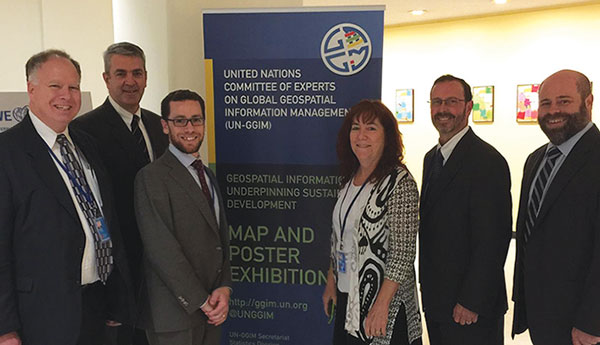
Members of the Global Geospatial Information Management (GGIM) Working Group attending the 5th Session
of the UN Committee of Experts on Global Geospatial Information Management.
The FGDC Office of the Secretariat provides support to the Global Spatial Data Infrastructure (GSDI) Association in order to increase international collaboration on spatial data infrastructure development. The GSDI Small Grant program uses resources from the FGDC, the Geoconnections Program of Natural Resources Canada, and the GSDI Association. The program supports national or subnational activities that foster partnerships, develop in-country technical capacity, improve data compatibility and access, and (or) increase political support for spatial data infrastructure. The four 2014 projects from organizations in Armenia, Belize, Ghana, and Uganda were completed in March 2015. Four new projects in Ecuador, Indonesia, Jamaica, and South Africa were awarded in July 2015. For more information, see gsdiassociation.org/index.php/projects/small-grants.html.
Cooperative Agreements Program Supports the NSDI |
| To encourage the development of the NSDI beyond the Federal level, the FGDC initiated the Cooperative Agreements Program (CAP) in 1994. Over the years, the CAP (1) fostered collaborations within all sectors of government, (2) helped develop an understanding of geospatial information in organizations new to the NSDI, (3) provided seed money to enable geospatial organizations to participate in the national effort to implement the NSDI, (4) promoted the importance of geospatial data standards, (5) promoted the development of standardized metadata by countless organizations, and (6) greatly expanded implementation of geospatial services on the Internet. The program was offered to local, regional, State, and academic geospatial data communities who not only benefited financially, but more importantly, validated an organization's geospatial initiatives and opened new opportunities and partnerships. Five CAP projects were concluded this year. Iowa completed a Fifty States Initiative project that developed a business plan to create a cooperative program to build and maintain statewide parcels and orthoimagery that tries to maximize investments made by both local and State government agencies, and develop incentives for further cooperation. Metadata training and outreach continued to be a significant outcome of the CAP. Through Alaska's Department of Transportation and Public Facilities and Florida's Miami-Dade County, training was provided on the internationally accepted geospatial metadata standards (ISO 19115). In addition, their materials were made available to all via the Internet. In a separate project, Miami-Dade County increased participation of the NSGIC GIS Inventory (gisinventory.net), with over 250 metadata containing links to standards-compliant data or data services. This effort supports Federal Data.gov and Geoplatform.gov activities to expose available geospatial data. And finally, North Carolina initiated its return on investment study for State geospatial activities. For more information on projects, please see www.fgdc.gov/grants.  Miami-Dade GIS Users' Group Metadata training session. |
U.S. Interagency Elevation Inventory |
| The USACE and USDA have recently joined the effort to update the U.S. Interagency Elevation Inventory, a collection of publicly available, high-accuracy elevation datasets for the United States and its territories. These groups join NOAA, FEMA, and USGS in maintaining the inventory, which provides an important central location for accessing information about high resolution topographic and bathymetric datasets. Additional agencies may also be joining in early 2016. The addition of these agencies helps to ensure that all federally held datasets are included in the inventory, which encourages accountability and effective development and management of Federal geospatial resources (NSDI Strategic Plan, Goal 2). The inventory provides awareness of and access to federally held data as well as collections from all other sources of publicly available data'‹ (State, Tribal, local)'‹. The inventory also supports the 3D Elevation Program (www.n'‹ationalmap.gov/3DEP/) and the Integrated Working Group on Ocean and Coastal Mapping ( www.seasketch.org/#projecthomepage/5272840f6ec5f42d210016e4). It is currently used for interagency planning of data collections, and work is underway to track datasets from initial interest in acquiring the dataset to its completion and inclusion in the inventory. In this way, the five-agency effort also supports an NDSI Strategic Plan objective to convene leadership to develop shared approaches to critical national issues through quarterly meetings to coordinate update efforts and build awareness of the Nation's elevation resources. Including datasets in the inventory increases awareness of and access to existing datasets, which reduces duplication of effort from unnecessary data collections and enhances use of existing federally purchased data. Inventory users can see the extent of datasets on a map, as well as determine information, such as the date of collection and quality level. Also provided is either a point of contact or, when available, a link to download the data and metadata. The inventory is provided to the public via NOAA's Digital Coast (coast.noaa.gov/digitalcoast) and was last updated in March 2015. For additional information, please visit the newly redesigned viewer at www.coast.noaa.gov/inventory.  United States Interagency Elevation Inventory Web site. |
Goals for Fiscal Year 2016
Over the coming year, the NSDI Strategic Plan actions and tasks marked for fiscal year 2016 will be implemented and the summary tables (Appendix E) will be updated to track the status of the implementation process. Goals for the coming year include the following:
Geospatial Interoperability Reference Architecture. The Program Manager-Information Sharing Environment is funding a joint initiative with the FGDC and technical support from DHS and DOI for implementation of the GIRA as a 'Wiki-like' online collaboration resource on the Geoplatform.gov. The goal of this initiative is to further enable the timely discovery, access, use, and collaboration for the enhancement and sustainment of the GIRA.
Challenges/Opportunities: The GIRA is intended to address challenges across the geospatial information sharing community related to use of different vernaculars and vocabularies between stakeholders; use of different architectural frameworks and accepted practices across Federal, intelligence, private sector, and local organizations; and use of different technical services and standards that are critical for geospatial data sharing and interoperability. The GIRA provides an opportunity to increase government geospatial information sharing of interoperable capabilities, to promote reuse of existing information assets, and to minimize Federal operational costs.
GeoCloud. The GeoCloud Incubator will continue to advance FGDC efforts to leverage cloud services. Working with the FGDC community, GeoCloud efforts will include automation of GIS deployments, integrated geospatial data catalog and publishing capability, migration of production ready pilots to the Geoplatform.gov shared services, and development of a cloud security framework for spatial data infrastructures.
Challenges/Opportunities: Cloud-based technologies are evolving at a phenomenal rate, requiring continued analysis and observation for applicability, risk, and appropriate adoption and integration into geospatial services. Through the GeoCloud initiative, the FGDC can continue research and development of a prototypical geospatial interoperability platform in the cloud-based service environment to demonstrate its potential.
NGDA Management Plan. The coming year will see the continuation of activities to meet the objectives and actions outlined in the NGDA Management Plan ( www.fgdc.gov/policyandplanning/a-16/ngda-management-plan) and will support meeting Objective 2.1 in the NSDI Strategic Plan. The actions to be completed in fiscal year 2016 will further the implementation of portfolio management of geospatial data and will take the combined efforts of the FGDC Steering Committee, NGDA Executive Theme Champions, NGDA Theme Leads, NGDA Dataset Managers, FGDC Office of the Secretariat, and the Geoplatform.gov Team.
Challenges/Opportunities: There needs to be continuing engagement by Federal partner agencies for the many concurrent activities to develop meaningful and consistent reporting for NGDA Themes and Datasets, and to ensure adequate resources to implement the NGDA A–16 Portfolio and its supporting tools. If these challenges are overcome, core Federal geospatial assets will be available for effective sharing, collaboration, and use of core geospatial data to support efficient and effective decision making.
Standards. Continue to advance NSDI Strategic Plan Action 3.1.2, which calls for developing strategic partnerships with existing standards development organizations and NSDI Strategic Plan Action 3.1.3, which calls for providing technical and educational support to agencies implementing NSDI standards and engaging the standards community through workshops or online information-sharing tools, such as Web meetings or social media.
Challenges/Opportunities: The main challenge facing the FGDC standards program is obtaining necessary support from NGDA Dataset Managers, Theme Leads, Executive Theme Champions, Theme Lead Agencies, and the FGDC Subcommittees/Working Groups to fulfill actions and tasks called out in the NSDI Strategic Plan.
Geospatial Metadata. Continue involvement in NSDI Strategic Plan implementation, including Geoplatform.gov and A–16 Supplemental Guidance - National Geospatial Data Asset Management Plan. Provide practical guidance for ISO metadata transition/implementation via the FGDC Geospatial Metadata Web site, ISO Geospatial Metadata Implementation Forum, ISO Geospatial Metadata Editors Registry, and possible continuation of the Metadata Summit series (2011 and 2013). Coordinate an enhanced harvesting and validation process to increase geospatial metadata holdings in the Data.gov and Geoplatform.gov catalog. Promote and manage the ISO Geospatial Metadata Editors Registry. Identify metadata-related issues and actions in support of the GIRA. And finally, create and manage a Geoplatform.gov geospatial metadata community.
Challenges/Opportunities: The challenge of meeting the technical demands to stay current on actively evolving ISO 191 series of geospatial standards can be supported through identifying ISO metadata implementation activities that can serve as shared learning experiences, coordinating metadata activities at the national and international level, and compiling efforts of effective geospatial metadata education and outreach resources.
National Geospatial Advisory Committee. The NGAC will provide ongoing review, feedback, and recommendations regarding the development and implementation of key issues and initiatives, including the ongoing implementation and development of the NSDI Strategic Plan, the continued development of the Geospatial Platform, development of portfolio management approaches, geospatial standards coordination, and geospatial data initiatives, which may include elevation, address, and transportation data. The FGDC will review and respond to advice and recommendations from the NGAC and will complete the next cycle of NGAC nominations and appointments in fiscal year 2016.
Challenges/Opportunities: The NGAC will face continuing challenges in developing effective advice and recommendations that reflect a consensus view across multiple sectors and perspectives on key issues, such as the implementation of the NSDI Strategic Plan, geospatial portfolio management, and the Geospatial Platform, as well as emerging issues and data initiatives.
International. A goal for the UN-GGIM is to ensure that geospatial information is included in the preparation of the Sustainable Development Goals. The UN General Assembly has commended the UN-GGIM for their efforts to promote the importance of reliable geographic and geospatial information for both monitoring and measuring goals. Activities pertaining to this will be reflected in the post-2015 development agenda that is scheduled for adoption in September 2015.
Challenges/Opportunities: The emphasis on utilization of geospatial information to support UN efforts presents challenges. Success will depend on the availability of high-quality, timely, and reliable data in conjunction with managing issues related to data collection, such as use, privacy, provenance, and accessibility.
National Address Database (NAD) Summit |
||
|
The USDOT and its partners from all levels of government recognize the need for a National Address Database (NAD). Accurate and up-to-date addresses are critical to transportation safety and a vital part of Next Generation 9-1-1. They are also essential for a broad range of government services, including mail delivery, permitting, election administration, and school siting. To date, there has been no national database of address points in the public domain, resulting in duplicative spending on address information across Federal, State, and local governments. The Government Accountability Office (GAO) reinforced this belief in its February 2015 report titled 'GEOSPATIAL DATA: Progress Needed on Identifying Expenditures, Building and Utilizing a Data Infrastructure, and Reducing Duplicative Efforts.' One of the recommendations from this report specifically addresses the need for a NAD: 'To better facilitate the coordination of'”and accountability for'”the estimated billions of dollars in federal geospatial investments, and to reduce duplication, the Secretary of the Interior, as the FGDC Chair, should direct the FGDC Steering Committee to create an address data theme with associated subcommittees and working groups to assist in furthering a national address database.'
|
FGDC Subcommittees and Working Group Report
The FGDC is supported by subcommittees and crosscutting working groups to address geospatial issues for the specific data types. The FGDC subcommittees and working groups are comprised of representatives from Federal agencies and FGDC-recognized stakeholder groups who share a common interest. Each subcommittee focuses on issues that pertain to coordination and standards associated with a geospatial data theme with regard to data collection, access, exchange, and applications using those data. Working groups address activities that crosscut or affect several subcommittees. Further information is available at www.fgdc.gov/participation/working-groups-subcommittees.
Many of the FGDC subcommittees actively assist in the implementation of the NGDA Management Plan and, in fact, many members of the subcommittees are designated as NGDA Theme Leads or NGDA Dataset Managers. Members of the subcommittees have updated and (or) registered NGDA Dataset metadata that is harvested for the Data.gov and Geoplatform.gov catalog. These actions increase opportunities for discovery, access, and shared use of the NGDA Datasets. The subcommittees' members are supporting the NGDA Theme and Dataset maturity assessments, which are critical to providing relevant and meaningful information for decision making by senior executives.
Cadastral Subcommittee
The Cadastral Subcommittee develops and implements plans to coordinate cadastral data-related activities among Federal, State, Tribal, and local governments, and the private sector. As examples, subcommittee members work with the wildland fire community to identify sources of land parcel data, standardize available data, and build sustainable operational procedures to provide land parcel data for wildland fire applications in coordination with States. The subcommittee works with public domain States—those States using the PLSS—to standardize the best available statewide data in the State, to identify the optimum maintenance work flow, and to publish a maintainable standardized dataset. The subcommittee's outreach Web site is at nationalcad.org.
The subcommittee also coordinates with other FGDC subcommittees on cadastral-related topics. Examples include coordination with the Boundary Working Group to identify, document, and locate cadastral data sources for boundaries that are dependent on cadastral features, and the FGDC Geodetic Control Subcommittee to explore the option for integrating control collected for cadastral datasets with national control datasets. Highlights for the subcommittee include the following:
Land Buy-Back Program for Tribal Nations (Buy-Back). The Buy-Back Program is an outcome from the Cobell v. Salazar lawsuit and is a program to support the reconsolidation of the fractionated interests on Indian Lands. There are over 300 Indian reservations in the United States and of these, 153 were identified as candidates for the program. Since 2012, the Bureau of Land Management (BLM) has completed the construction of a geodatabase and validating land records data for over 500,000 Indian parcels on 80 of the 153 reservations. The remaining 73 of 153 reservations will be completed in 2016. Upon request from the Indian Buy-Back Program, the BLM is performing updates to the geodatabases for these reservations. The standard PLSS data combined with the land descriptions from the Bureau of Indian Affair's (BIA) Trust Asset and Accounting Management System are the major sources of information used to construct the database. In addition to the buy-back reservations, BLM will complete geodatabases and data validation for 25 reservations in 2015 and 30 reservations in 2016. In 2016, much of the responsibility for this effort related to the Indian tract/parcel geodatabases will be transferred to the BIA. The BLM will retain responsibility for PLSS data. The BIA also is the lead agency for the reservation boundary updates. The BLM and the BIA continued working together to improve records and update reservation boundaries that are critical to supporting the program.
Federal Rights and Interests. The Cadastral Subcommittee completed a review of Federal rights databases and produced a final summary report.
Standardized PLSS - Nationwide Status. The PLSS dataset is a National Geospatial Data Asset. The BLM facilitated and (or) completed the standardization of 29 of the 30 PLSS States, with Oklahoma still pending but scheduled for completion in fiscal year 2016. These are initial standardized datasets that are continuing to be updated with added control, partnership activities, and new surveys. The Cadastral Subcommittee completed the dataset collection level metadata and registered it in the Data.gov and Geoplatform.gov catalog.
Supporting PLSS Cadastral National Spatial Data Infrastructure (CadNSDI) Data |
| The BLM is in the process of adopting a commercial off the shelf product for continued maintenance of the PLSS datasets and will complete the migration of the data for all States to a parcel fabric in 2016. The State of Montana, as a State data steward, is completely operational in the parcel fabric and is publishing quarterly updates through the Esri's Parcel fabric tools. The cooperative project was recognized with an Esri 2015 Special Achievement in GIS award ( events.esri.com/conference/sagList/?fa=Detail&SID=2117). More information on the project can be found at medium.com/@Esri/bureau-of-land-management-cadastral-survey-adopts-esri-s-parcel-fabric-51ff44bb87af. |
Cadastral Survey Control. Partners from Utah, Montana, Idaho, BLM's Eastern State Office, and private land surveyors developed a multi-State (multijurisdictional) cadastral control database that supports the online submission, review, and publication of collected survey control. The BLM continues its efforts to coordinate with NGS to find an appropriate national hosting site for a national cadastral control dataset.
Digital Parcel Map Data and State Stewardship. The BLM continued to support the advancement of State stewardship for the assembling, aggregation, standardization, and publishing of locally sourced parcel data. Through the wildland fire support and boundary quality improvement efforts, it is very apparent that State-hosted, standardized, accessible parcel data is essential to support many Federal, State, and local programs.
Cultural Resources Subcommittee
The purpose of the Cultural Resource Subcommittee is to identify, prioritize, implement, coordinate, and oversee the strategies and tasks required to support the national cultural resource geospatial data theme and to coordinate these activities across Federal, State, Tribal, local, and private sector geospatial programs to that end. Because each State/Tribal historic preservation office, certified local government, and Federal agency operates independently to collect, maintain, and utilize their portion of the repository of over four million cultural resources nationwide, coordination in data standards is a key aspect for the utility of the data, required for Federal regulatory needs, disaster response, and preparedness, as well as for climate change studies. The subcommittee provides the framework for developing cultural resource data standards to facilitate data sharing, in addition to fostering coordination of data collection efforts among stakeholders. Subcommittee members include 20 Federal agencies as well as 10 State and 10 Tribal participants. The subcommittee's accomplishments for 2015 include the following:
- Developed and approved a statement of goals and definition of the purpose of the subcommittee in July 2015.
- Continued development of an initial working draft of the proposed cultural resource data transfer standard throughout 2015. Partnered with the National Conference of State Historic Preservation Officers to survey States and Tribes to provide feedback and make suggestions on the format and elements to incorporate into the standard in February 2015. Responses to the survey incorporated into the development of a final set of feature-level metadata fields to be used in the proposed cultural resource spatial data transfer standard in July 2015.
- Supported the implementation of the NGDA Management Plan by reviewing and approving the template for the NGDA Theme Strategic Plans in May 2015. Reviewed and approved the process for the addition, change, or removal of NGDA Datasets from a Theme, and ensured that the Cultural Resource Theme NGDAs were registered in the Geoplatform.gov and Data.gov catalog.
Geodetic Control Subcommittee
The Federal Geodetic Control Subcommittee helps coordinate the planning and execution of geodetic surveys, developing standards and specifications for these surveys, and exchanging geodetic survey data and technical information among Federal agencies. To provide effective leadership in these activities, NGS participates in international meetings to collaborate on international reference frames, national meetings to educate the public on U.S. national reference frames, and smaller regional meetings to discuss the particular dynamics of local geographies. These efforts directly support the NGDA Strategic Plan's Goal 3 that calls for convening leadership of the national geospatial community. Some of the subcommittee's accomplishments for fiscal year 2015 are the following:
- The NGS hosted the 2015 Geospatial Summit to provide information on the replacement of the North American Datum of 1983 (NAD 83) and North American Vertical Datum of 1988 (NAVD 88) to improve the National Spatial Reference System (NSRS).
- The NGS developed Geodesy and Mapping educational videos and online lessons to highlight basic principles of Geodesy, the importance of the science within mapping applications, and how changes will impact their work.
- The NGS continued to coordinate with the International Earth Rotation and Reference Systems Service as lead agency for providing Global Positioning System (GPS) orbits to the International Global Navigation Satellite Systems (GNSS) Service. The NGS also performed a site survey at the Mauna Kea Very Long Baseline Array Observatory. These efforts help determine the International Terrestrial Reference Frame, which is the basis for all GNSS positioning and is in support of the Global Geodetic Reference Frame that was included in a resolution adopted by United Nations General Assembly.
- The Arkansas Geodetic Advisor collaborated with the USACE, USGS, and the Arkansas Highway and Transportation Department to collect simultaneous GPS observations along the Mississippi River. In fiscal year 2015, GPS observations on 137 bench marks were shared, improving the accessibility of NAVD 88 heights in the regions.
- The NGS is working with the BLM and State partners to discuss options for maintaining the cadastral control database developed in Montana. Transitioning Cadastral and Geodetic Control databases and hosted services to the Geoplatform.gov would better serve the public providing Web services to connect to local, State, and Federal governments.
- The NOAA continued working with Canada to replace the International Great Lakes Datum of 1985 in 2025. This year, various partners completed a simultaneous GPS campaign at the U.S. and Canadian tide gages. This type of survey is repeated over time to monitor isostatic rebound in the Great Lakes region.
- The Pacific Geodetic Advisor continued working with USGS to accurately monitor water levels in Maui's Aquifers by increasing the density of Maui's vertical geodetic control network.
North American Datum Modernization |
|
| In 2022, NOAA's NGS will replace the North American Datum of 1983 (NAD 83) and the North American Vertical Datum of 1988 (NAVD 88) with new Reference Frames (Datums) to improve the NSRS. Determining positions relative to the new reference frames (geometric and geopotential) will rely primarily on GNSS, such as the GPS, as well as on a gravimetric geoid model resulting from NGS' Gravity for the Redefinition of the American Vertical Datum (GRAV-D) Project. For more information, visit (geodesy.noaa.gov/datums/newdatums). | 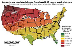 |
| Education The NGS hosted the 2015 Geospatial Summit on April 13–14, 2015, to update constituents on progress towards the new reference frames, inform users how to prepare for the transition, and collect feedback from stakeholders. Twenty U.S. Federal agencies from eight departments attended the event, along with representatives from State and local governments, the private sector, and academia. For more information, visit geodesy.noaa.gov/2015GeospatialSummit. Additionally, NGS continued partnering with The COMET® Program (www.comet.ucar.edu) to develop Educational Videos and online lessons. |
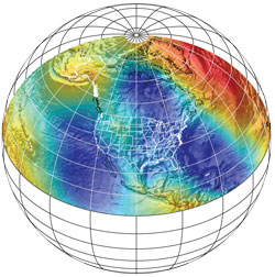 |
| Data Collection and Analysis The Gravity for the Redefinition of the American Vertical Datum (GRAV-D) Project includes an extensive aerial gravity data collection survey, which will cover all U.S. States and territories when completed. This multiyear effort remained on schedule, and aerial gravity collected from the country and territories has reached 45% in fiscal year 2015. For more information, visit geodesy.noaa.gov/GRAV-D. This year, NGS also completed the second of three planned geoid slope validation surveys (GSVS). The most recent project was completed in Iowa to test the accuracy of the gravimetric geoid model, which includes GRAV-D airborne gravity data. Each GSVS compares the geoid slope of various surveying techniques, including GPS, geodetic leveling, deflection of the vertical, and terrestrial gravity data. To date, the results of these surveys have confirmed that the accuracy of differential orthometric heights (heights relative to sea level) in the new geopotential reference frame will be 2 centimeters over any distance, where GNSS usage is possible. For more information, visit geodesy.noaa.gov/GEOID/GSVS14. |
  |
Geologic Subcommittee
The Geologic Data Subcommittee coordinates Federal and non-Federal interests in geologic data, including the facilitation of exchange of information and transfer of data; the establishment and implementation of standards for quality, content, and transferability; and the coordination of the identification of requirements and the collection of spatial data to minimize duplication of effort where practicable and economical. The Geologic Data Subcommittee Web site is at ngmdb.usgs.gov/fgdc_gds.
Through coordination provided by the National Geologic Map Database (NGMDB) project, the USGS, State Geological Surveys (represented by the Association of American State Geologists (AASG)), and the National Park Service completed the initial stage of evaluation and test implementation of a standard geologic map database design that is intended to be proposed as a FGDC Standard (see ngmdb.usgs.gov/Info/standards/NCGMP09). This design, temporarily named NCGMP09, was developed in 2009, under auspices of the USGS National Cooperative Geologic Mapping Program. The agencies noted above worked through each section of the documentation and GIS database design, and recommended a set of modifications. This work was accomplished through a few monthly teleconferences, several listserves for communicating technical challenges and conclusions, and an interagency working group. Upon completion of the recommended changes, NCGMP09 will be republished as a Version 2, and will then be brought before the FGDC Geologic Data Subcommittee for planning to propose as an FGDC standard; this is anticipated to be initiated in 2016. Having the FGDC approval on a standard has a noticeable effect, which is proved by the acceptance of the Cartographic Standard for Geologic Map Symbolization by the community.
Homeland Infrastructure Foundation-Level Data Subcommittee
The Homeland Infrastructure Foundation-Level (HIFLD) Subcommittee develops, promotes, and executes a coordinated strategy for acquisition or development of homeland infrastructure geospatial information for Federal agencies while creating and utilizing partnerships with State, Tribal, territorial, local, and private organizations. The subcommittee serves as a focal point to coordinate homeland infrastructure geospatial information requirements among Federal, State, Tribal, territorial, local, and private organizations and to ensure coverage of homeland infrastructure geospatial information for all States, territories, and possessions. It consists of Federal agencies that, as part of their mission, collect or finance the collection of infrastructure geospatial information.
The subcommittee is supported by a HIFLD Program Management Group, which is composed of the following organizations: DHS Geospatial Management Office, DOI Office of the Geospatial Information Officer, FEMA, National Protection and Programs Directorate, NGA, and U.S. Department of Defense Office (DOD) of the Assistant Secretary of Defense for Homeland Defense and Americas' Security Affairs (OASD–HD&ASA).
The fiscal year 2015 accomplishments of the subcommittee include the following:
- The subcommittee coordinated the production and dissemination of the 2015 release of Homeland Security Infrastructure Program (HSIP) data products and Web services.
- The subcommittee extended new memberships to the NSGIC, National Capital Regional Planning Committee, and USPS to enable them to provide input on the strategic direction of HIFLD and ensure their feedback is incorporated in the Common Operating Data requirements management process.
- The Program Management Group launched a Data Licensing Tiger Team to examine the release of HSIP data layers to resolve access challenges faced by HSIP consumers. This ongoing effort will result in increased community access for select HSIP datasets via their hosting on the Federal Geospatial Platform.
- The legacy HIFLD Web site, which serves as a secure online community for over 6,000 users, was successfully transitioned to the DHS Geospatial Information Infrastructure (GII) environment. The HIFLD user base can now access HSIP data alongside supporting GII resources. The subcommittee conducted a series of outreach events via live webinars to assist the user base in acquiring Homeland Security Information Network credentials.
- The Common Operational Data Management Plan was established to formalize the adjudication process for new datasets based on the A–16 Portfolio management. The subcommittee applied intake criteria from the Plan to assess the Defense Industrial Base submitted by the Industrial Analysis Center.
- Subcommittee representatives participated in outreach events, including the Licensed Data Forum facilitated by MAPPS, United States Geospatial Intelligence Foundation conference, and the NAPSG Homeland Security Summit to address data needs and access challenges facing users from diverse stakeholder groups. The subcommittee briefed the HIFLD community regarding its 2015 roadmap at the Esri Federal Users Conference and participated in a series of meetings with fusion center representatives at the Esri National Security Summit and Users Conference. The subcommittee regularly performed HSIP demonstrations to working groups and stakeholders at multiple levels of government, including the Louisiana State Emergency Management Office.
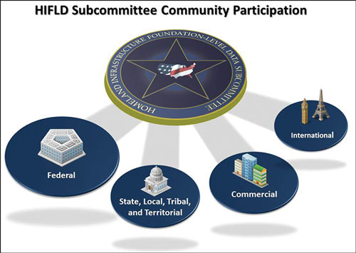
Marine and Coastal Spatial Data Subcommittee
The primary mission of the Marine and Coastal Spatial Data (MCSD) Subcommittee is to develop and promote the Marine and Coastal NSDI. The vision of the Marine and Coastal NSDI is that current and accurate geospatial coastal and ocean data will be readily available to contribute locally, nationally, and globally to economic growth, environmental quality and stability, and social progress. The subcommittee is chaired by the NOAA Geospatial Information Officer.
For the past 5 years, the subcommittee has worked in an integrated manner, seeking critical partnerships with other Federal, State, and local governments, as well as interagency and multisector activities in the marine and coastal environment focusing on spatial data. These activities include the National Ocean Council and the ocean.data.gov data portal, the Integrated Working Group on Ocean and Coastal Mapping, and the Integrated Ocean Observing System, to name a few key initiatives. Since the marine and coastal geospatial community is broad and diverse, the FGDC's MCSD Subcommittee seeks leveraging ongoing activities in other sectors. For the year 2015, accomplishments of the subcommittee include the following:
- Supported the implementation of the NGDA Management Plan by reviewing and updating NGDA Dataset baseline inventory for the Water - Oceans and Coasts Theme and registering the Theme's NGDA Datasets in the Data.gov and Geoplatform.gov catalog, and updated the Water - Oceans and Coasts Theme pages on Geoplatform.gov.
- A Federal mandate under the Ocean and Coastal Mapping Integration Act of 2009 established the requirement to 'coordinate and leverage ocean and coastal mapping efforts to improve access to existing data and efficiently collect future data.' The Interagency Working Group on Ocean and Coastal Mapping has developed a National Coastal Mapping Strategy to meet this mandate. This group helped the Geospatial Platform management team to expand the functionality of the Geospatial Marketplace to meet similar requirements for the coastal and ocean mapping community.
- Continued to support and grow the Marine Planning Portal Network (MPPN); through a combination of a listserv, webinar series, and informational resources, it serves as one of the main conduits for communication between State, regional, and national portals, applications, and planning efforts. The MPPN continues to grow and now has 110 listserv members.
- The NOAA's NGS is collecting aerial oblique imagery prior to natural disaster events (that is, hurricanes, tornadoes, oil spills, and so forth) to aid emergency and coastal managers with the information they need to develop recovery strategies, facilitate search-and-rescue efforts, identify hazards to navigation and hazardous materials spills, locate errant vessels, and provide documentation necessary for damage assessment through the comparison of before-and-after imagery. Additionally, oblique imagery allows determination of the extent of the damage inflicted by the storms and comparison of this storm's forecast models to actual damage to the ground. The NGS' oblique imagery is available online and employs a front-end Web page that quickly provides imagery with coordinate attributes for the public and allows downloadable imagery. The National Digital Orthoimagery Program Subcommittee also supports this effort.

NGS oblique imagery of Manhattan. - Updates to the MarineCadastre.gov Web site were released that includes a new National Viewer, updates to the Data Registry, and a refreshed look and feel to the entire Web site. The project developed or maintained 57 data layers over the course of the year. The project team from the Bureau of Ocean Energy Management (BOEM) and NOAA continued strong, tightly integrated relationships with regions that are actively engaged in marine planning, specifically the Northeast, Mid-Atlantic, and West Coast. The site also has an active social media component through Facebook and Twitter.
National Digital Orthoimagery Program Subcommittee
The National Digital Orthoimagery Program (NDOP) Subcommittee is responsible for developing, promoting, and executing a national strategy for acquisition or development of orthoimagery data for Federal agencies, while creating and utilizing partnerships with State, local, Tribal, and private organizations and supports NSDI Strategic Plan Objective 2.2. The NDOP Subcommittee is accountable to the FGDC Steering Committee and provides recommendations to the FGDC CG. These are the policy and operational authorities, respectively, responsible for providing leadership and direction in the use and development of geospatial data and information across Federal geospatial programs and in conjunction with public, academic, and private sector partners and stakeholders. The subcommittee accomplished the following in 2015:
- At the recommendation of GAO and the direction of the FGDC Chair, the NDOP reassessed the feasibility of the 'Imagery for the Nation' initiative, with the goal of identifying discrete steps that could be taken to further a national imagery program benefitting government at all levels. The NDOP met in person in May and again via teleconferences in June and prepared a report that assessed feasibility, offered options, and identified barriers that must be resolved before an initiative of this magnitude can succeed. The report was presented at the September FGDC Steering Committee Meeting.
- As the primary source of aerial imagery for USDA, the Farm Service Agency (FSA) administers the National Agriculture Imagery Program (NAIP), leveraging partnership funds from other Federal, State, and local entities to acquire imagery during the growing season over the continental United States. In 2015, FSA acquired nearly 1.8 million square miles of four-band (natural color and near color infrared) imagery in 27 States. Two States were collected at 0.5-meter resolution through a partnership 'buy-up' option and all the remaining States are at 1-meter resolution. An innovative addition to NAIP, called the Early Access Web Services, provides minimally processed NAIP imagery via Web service protocols on average between 2 and 7 business days after acquisition. This allows FSA and partner agencies to perform time-sensitive work with the most current imagery available months in advance of receiving production-level NAIP imagery.
- High resolution imagery was collected through multiple funding partnerships with local, State, and Federal agencies. By combining the requirements and funding of these entities, 109,788 square miles of 3-inch, 6-inch, 1-foot, and 2-foot imagery was efficiently received for the benefit of all. The last High Resolution Orthoimagery program data, acquired through the multiple funding partnerships, was received in September 2015. With responsibility for management of the HSIP transferring from NGA to DHS, and with the USGS/National Geospatial Program's elimination of the 'in-kind' services provided to the HSIP 133 Cities Urban Areas imagery acquisitions, there does not currently appear to be a clear methodology to coordinate future high resolution acquisitions. Therefore, NDOP anticipates fiscal year 2015 to be the last year of coordinated acquisition in this area.
- The NOAA collected tide-controlled imagery in 54 coastal areas to support shoreline mapping efforts.
- The NDOP members (USDA-NRCS, USDA-FSA, NOAA, and DOD-NGA) have worked together to acquire new Orthoimagery in fiscal year 2015 for the following: Hawaii, Northwestern Hawaiian Islands, Commonwealth of the Northern Mariana Islands, Republic of Palau, and the Federated States of Micronesia.
- The NDOP Technical Subcommittee held numerous meetings throughout the year to discuss technical issues that affect our member agencies, with the principal goal to share information and save time and costs. In 2015, some key topics of discussion were unmanned aircraft systems (Technology and Agency Acquisition Policy), new digital camera systems, satellite imagery systems, scanning and archiving legacy aerial photography, and high resolution imagery services.

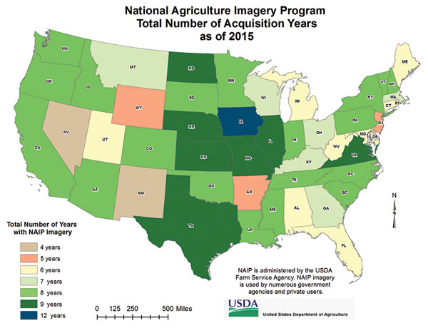
Spatial Water Data Subcommittee
The Advisory Committee on Water Information (ACWI) and FGDC created the Subcommittee on Spatial Water Data (SSWD) to assist coordination of Federal and non-Federal interests in spatial water data, including (1) facilitating the exchange of information and transfer of data; (2) establishing and implementing standards for quality, content, and transferability; and (3) coordinating the identification of requirements and the collection of spatial data to minimize duplication of effort where practicable and economical.
The SSWD has been leading efforts to engage the community and to design and scope the Open Water Data Initiative (OWDI). The OWDI was launched by the FGDC and the ACWI in the summer of 2014. The goal of the OWDI is to bring currently fragmented water information into a connected, national water data framework by leveraging existing systems, infrastructure, and tools to underpin innovation, modeling, data sharing, and solution development.
The subcommittee is exploring three initial use cases, which help to identify critical data needs, then facilitating and making the needed datasets openly available as Web services and downloads. The initial use cases were chosen to cover important societal needs and to address several diverse facets of the water information infrastructure. The three initial use cases are:
- Flooding. The National Flood Interoperability Experiment (NFIE) is a joint effort between FEMA, the National Weather Service (NWS), NOAA, USGS, USACE, the academic community, and commercial partners. The goal of NFIE is to demonstrate a transformational suite of science and services for the next generation of national flood hydrology and emergency response.
- Drought. The OWDI drought use case is aimed at providing an integrated picture of water supply and drought information sources, and emphasizes integration and visualization of information from disparate sources.
- Spill Response. The goal of the OWDI spill response use case is to identify datasets, tools, and environmental parameters that would enable Web-based predictive modeling of the path and traveltime of contaminants as they travel downstream.
Much progress has been made in the past year. A few highlights follow:
- Outstanding engagement and participation in the SSWD, with over 90 people from more than 30 organizations indicating interest, and with half attending the meetings on a regular basis.
- Special OWDI tracks offered at the American Water Resources Association (AWRA) national conferences in 2014 and 2015.
- A featured collection of technical papers related to OWDI, hosted by the Journal of the AWRA.
- Based on user feedback, a 'flattened' data model developed using National Hydrography Dataset Plus (NHDPlus).
- The linking of USGS streamgaging stations and NWS forecast points to NHDPlus.
- Development of OGC and Esri Web services for NHDPlus streamgaging stations.
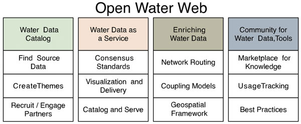 The Open Water Data Initiative can be envisioned as four primary types of activities contributing to the development of an 'Open Water Web,' a connected national water data framework by leveraging existing systems, infrastructure, and tools, as shown in the figure below: (1) development of a water data catalog; (2) serving water data via the Internet in machine-readable formats; (3) enriching water data through spatial analysis and modeling; and (4) fostering a community or 'marketplace' through which tools, best practices, and data are shared. |
Transportation Subcommittee
The Transportation Subcommittee works to coordinate and support the NSDI and other transportation data-related activities among stakeholders. The Subcommittee's current areas of interest include all modes of transportation, transportation networks, terminals, and services (including intermodal freight and passenger), and the movements of people and commodities using them. The subcommittee supports the efforts of NGDA Theme Lead for the Transportation Theme. The following are highlights for the year:
- The Transportation Subcommittee presented its activities to the FGDC CG in May 2015.
- In April, USDOT hosted the National Address Database Summit. See article on page 25.
- The NGDA Dataset Manager for the railroad network focused on a major update to this dataset, which is conflating the Federal Railroad Administration rail network with data that was developed by NGA. The final product, the North American Rail Network, is planned to be completed in October 2015, and will be the primary rail network for all of the Federal Government and the rail industry.
- The USDOT registered the Transportation Theme's NGDA Datasets in the Data.gov and GeoPlatform.gov catalog. The Theme Lead supported the implementation of the NGDA Management Plan by working with Dataset Manager and coordinated baseline NGDA Dataset lifecycle maturity assessments.
- The USDOT implemented its policies for metadata, procedures, and guidelines for using the clearinghouse, developing transportation data standards, and creating a geospatial strategic plan for USDOT.
- The second annual submission of the All Roads Network of Linear Referenced Data (ARNOLD) was received. Of the 52 submissions (one from each State Department of Transportation, plus from the District of Columbia and Puerto Rico), 38 were able to meet the new 'all roads' requirement, 10 were slightly lacking, and 4 are in need of assistance.
Vegetation Subcommittee
The Vegetation Subcommittee was established to coordinate terrestrial vegetative data-related activities that include promoting accurate and current standards, financed in whole or in part by Federal funds; exchanging information on technological improvements; encouraging the Federal and non-Federal communities to identify and adopt the standards and specifications; and collecting and processing the requirements of Federal and non-Federal organizations. Federal participants in the Subcommittee provide leadership to facilitate: (1) the revision and implementation of the FGDC Vegetation standard and the revision of the classification hierarchy according to the FGDC Vegetation standard, which are used in vegetation classification, mapping, and inventory; (2) the development of partnership programs with Federal agencies, States, Tribes, localities, academia, and the private sector; (3) addressing user and natural resource needs, (4) identifying needs for standards and metadata to support the NGDA Land Cover and Land Use and Biota Themes; and (5) the adoption of goals to support the NSDI strategy, A–16 portfolio management, Data.gov, and GeoPlatform.gov. The subcommittee meets monthly to facilitate partner communication and planning. In fiscal year 2015, the subcommittee completed the following activities:
- Formally released the National Vegetation Classification (NVC) for the conterminous United States in fall 2015 (usnvc.org). Also finalized the NVC charter and implementation plan. The NVC is a central organizing framework for how all vegetation in the United States is inventoried and studied, from broad-scale formations (biomes) to fine-scale plant communities. The purpose of the NVC is to produce uniform statistics about vegetation resources across the Nation, based on vegetation data gathered at local, regional, or national levels.
- Oversaw the ongoing vegetation hierarchy revisions, specifically the division level of the NVC standard, including hosting a workshop for the review of the macrogroups in Linthicum, Maryland, in fall 2014. Submitted for publication the report of the Hierarchy Revision Working Group, which introduces the upper formation levels of the vegetation classification, and provided a description for each type, following the FGDC Vegetation Classification standard format.
- Finalized the processes for the National Vegetation peer review. The results of the peer reviews and the policy decisions will be used to identify the new vegetation types and modifications to vegetation types currently described in the NVC.
- Initiated three projects focused on archiving and increasing access to high-quality vegetation plot data for the Atlantic Coastal Plain, the Mid-Atlantic States, and California.
- Initiated two regional vegetation classification projects that will improve our understanding of the NVC in the Artic and Boreal Region of Alaska and the Chihuahuan Desert.
- Supported efforts to identify the range of options available for housing the components of the NVC and to identify options that would meet the FGDC needs for vegetation data.
- Continued to develop the cyber infrastructure to support the NVC, specifically the Hierarchy Browser search capability. Also, through support to the Ecological Society of America Vegetation Panel, continued to maintain a public archive for vegetation records in vegbank.org.
- Hosted a fieldtrip at the Society for Range Management Annual Meeting in San Jose, California, to sites illustrating important range management issues, and hosted a booth at the Ecological Society of America (ESA) Conference in August 2015.
- Endorsed the publication of 'A Shared Vision for the California Survey of Vegetation' as a project consistent with the NVC standard and hierarchy. This project was funded with a NSDI Cooperative Agreements Program grant to the California Native Plant Society and the California Department of Fish and Game to establish linkages between the alliances recognized in the Manual of California Vegetation and alliances of the NVC, www.fgdc.gov/grants/2012CAP/projects/G12AC20142.
- The Forest Service Existing Vegetation Classification, Mapping, and Inventory Technical guide (Version 2.0) was published after substantial input from the FGDC Vegetation Committee and ESA Vegetation Panel members. The endorsement from the FGDC Vegetation Subcommittee showed that the project and publication was consistent with the FGDC Vegetation Standard. The guide is available at www.fs.fed.us/emc/rig/protocols/vegclassmapinv.shtml.
- Secured new funding through an interagency agreement (USFS/USGS) for the Ecological Society of America's Vegetation Classification Panel to continue their work in vegetation classification and education.
Wetlands Subcommittee
The Wetlands Subcommittee promotes standards of accuracy and consistency in Federal geospatial wetlands data, exchanges information on technological improvements for collecting spatial wetlands data, encourages Federal and non-Federal communities to identify and adopt standards and specifications for spatial wetlands data, and collects and processes the requirements of Federal and non-Federal organizations for spatial wetlands data. This year, the subcommittee worked on the following:
- Facilitated the development of authoritative NGDAs by updating the Data Collection Requirements and Procedures for Mapping Wetland, Deepwater, and Related Habitats of the United States. This document describes the technical procedures and requirements for wetlands map data and is intended to aid organizations or individuals mapping wetlands and applying the Cowardin classification system. The document also explains the appropriate application of the wetland classification and mapping process, and how to achieve the data quality requirements required by the FGDC. For more information, see www.fws.gov/wetlands/Documents/Data-Collection-Requirements-and-Procedures-for-Mapping-Wetland-Deepwater-and-Related-Habitats-of-the-United-States.pdf.
- To facilitate the development and updating of the NSDI wetlands layer, the EPA Wetland Program Development Grants request for proposals language was augmented by adding information on the requirement to comply with the FGDC Wetlands Mapping Standard if Federal funds are used to map wetlands. For more information, see www.fgdc.gov/standards/projects/FGDC-standards-projects/wetlands-mapping/2009-08%20FGDC%20Wetlands%20Mapping%20Standard_final.pdf.
- To ensure that spatial data from multiple sources (Federal, State, Tribal, regional, and local governments; academia; and the private sector) could be integrated into the NGDA Wetlands Layer, the Subcommittee worked with the Association of State Wetlands Managers to produce and present a webinar on the Wetlands Mapping Standards and Procedures. This webinar reviewed the Data Collection Requirements and Procedures, the FGDC Wetlands Mapping and Classification Standards, and contact information to assist wetland data creators in contributing their data to the NGDA Wetlands Spatial Data Layer. For more information, see www.fws.gov/wetlands/Data/Contributed-Data.html.
- Wetlands data for over 125 million acres of the United States was contributed from 12 contributing Federal, State, and local agencies in fiscal year 2015. All data submitted to the NSDI wetlands layer must comply with the National Wetlands Classification Standard and the FGDC Wetlands Mapping Standard. Rigorous quality-control and quality-assurance processes and tools are implemented at all parts of data creation and submission.
- The National Wetlands Inventory dataset was registered in the Data.gov and Geoplatform.gov catalog and includes access to all of the wetland data endpoints, including Web applications, data downloads, and Web mapping services. This ensures the wetlands data are available to a diverse set of devices operated by end users comprising a full range of roles and skills. This NGDA dataset is part of the Waters - Inland Theme Community. For more information, see cms.geoplatform.gov/a16waterinland-home.
Providing Online Information on Status and Utility of Wetlands Digital Data |
One of the guiding principles of the NSDI is development of authoritative National Geospatial Data Assets at the scale needed for shared uses by Federal, State, Tribal, regional, and local governments; academia; the private sector; and the public. The wetlands layer has been collected using a consistent classification standard and data collection procedures. The development of such a large and robust dataset, created by many different data contributors over many years, using imagery captured at different scales with different types of film or sensors, on different years, inherently creates a patchwork of data. The usability of wetlands data for various uses is driven by the type, scale, and date of the imagery used to collect the wetlands digital data. This information is available by clicking on the data source layer on the Wetlands Mapper, which provides status maps on the image scale, image year, and image source. Users can also find out where new and updated data have recently been added to the Wetlands layer and where current mapping projects are under way by referencing the 'Wetland Mapping Projects Mapper' map. This data usability and status information is also available to the user by querying a wetland polygon in the Wetlands Mapper and is included in the data downloads.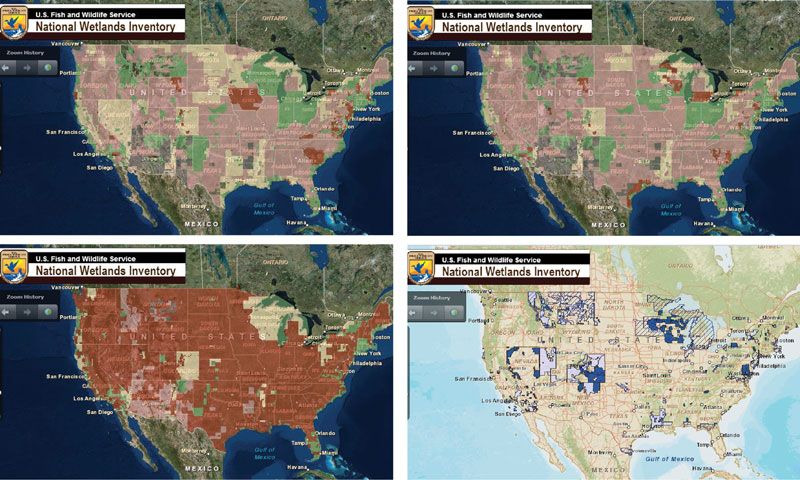 Wetlands data usability maps available on the Wetlands Mapper showing the Image Scale (upper left), Image Year (upper right), Image Source (lower left), and new data additions and current projects (lower right). Providing information on data creation and status, via maps that are a click away, allows the user of the wetlands data layer to make informed decisions about the usability of the data for their specific purpose. It also identifies specific areas where investments are needed to upgrade the wetlands layer of the NSDI to meet Federal agency missions and other national needs. Visit the Wetlands Mapper at www.fws.gov/wetlands/Data/Mapper.html. |
Global Geospatial Information Management Working Group
The purpose of the FGDC GGIM Working Group is to coordinate and align the U.S. position with the efforts of the UN-GGIM. The primary activity of the GGIM Working Group is participating in UN-GGIM meetings and related conferences. Members of the group are from several Federal agencies, including the Census Bureau, DHS, EPA, FEMA, NGA, NOAA, DOI, USDOT, USGS, and U.S. Department of State. The activities of the GGIM Working Group can be found on page 20 under Supporting International Activities.
Metadata Working Group
The Metadata Working Group promotes awareness and best practices among FGDC member agencies and NSDI stakeholders about the metadata component of geospatial data; facilitates the coordination, development, use, sharing, and dissemination of geospatial metadata; supports the implementation of geospatial metadata and other related semantic and structural (that is, nongeospatial) metadata standards established by Federal, national, and international standards organizations, such as the FGDC, OGC, American National Standards Institute, ISO, Dublin Core Metadata Initiative (DCMI), Open Source Metadata Framework (OMF), Ecological Metadata Language (EML), and the World Wide Web Consortium (W3C).
In fiscal year 2015, the Metadata Working Group (MWG) provided direct support to the FGDC Metadata Program and actively engaged in a range of NSDI initiatives, including the following:
- Participation and presentations within the MWG quarterly teleconferences, FGDC Standards Working Group, ISO Implementation Forum sessions, and Open Geospatial Consortium North American Forum (June 2015).
- Participation in metadata activities supporting the NGDA Management Plan, Project Open Data, Data.gov, and GeoPlatform.gov.
- Assessment of the NSDI Strategic Plan and the role of metadata to support specific tasks.
- Published and provided user reviews to the FGDC ISO Geospatial Metadata Editors Registry.
- Served as the primary conduit for the communication about geospatial metadata and other related semantic and structural (nongeospatial) metadata standards, tools, training, and implementation.
- Coordinated with the INCITS-L1 group who provided regular ISO geospatial metadata updates for the MWG.
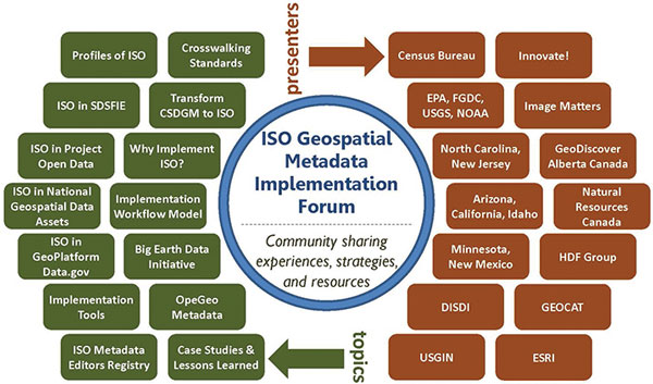
Presenters and topics provided at ISO Implementation Forum sessions.
National Boundaries Group Working Group
The National Boundaries Group (NBG) was formally designated as a Federal Geographic Data Committee (FGDC) working group in 2014. The NBG develops nationally consistent boundaries that are integrated using the same geographic base. The goal is to make sure Federal boundary sources are current, consistent, and accurate. In 2015, the NBG accomplished the following:
- The NBG now has a public community page on the Geoplatform.gov at cms.geoplatform.gov/a16govunits/NBG and a page for the associated Federal Lands Workgroup at cms.geoplatform.gov/a16govunits/FederalLands. There is also a private community for internal communications.
- The Federal Lands Workgroup continued to test and refine existing data standards to develop an aggregated Federal lands geodatabase that meets common agency needs.
- A draft geodatabase, supported by the USGS Gap Analysis Program to update the Protected Areas Database (also known as PAD-US) and presented to the Federal Lands Workgroup in August 2015, is available for review. The geodatabase model separates Federal fee, easement, and management designation (for example, National Monument and Wilderness Area) boundaries to highlight topology overlap errors within and between agency datasets.
- The Federal Lands Working Group requested documentation to track source data files and field mapping used to translate Agency data. This spreadsheet is available for review and to assess the compatibility and completeness of core attributes. The working group already documented 'Agency Name' for Federal land managers with a standard abbreviation to improve data compatibility.
- The NBG is continuing collaboration with the Cadastral Subcommittee to identify where boundaries are coincident with cadastral features. The Census Bureau has operationalized the results of this activity with the BQARP.
- The NBG introduced the Tribal Land Boundary Working Group as a platform for Federal agencies and Tribes to create a unified source of Tribal land boundary data. The working group is identifying the data and communication needs for agencies and governments using Tribal boundary data, including the Census Bureau, DOI, FEMA, EPA, USFS, and Tribal governments.
- The Census Bureau provided an overview describing Tribal boundaries, statistical boundaries, and how these geographical areas are defined solely for data collection, tabulation, and analysis.
- The FEMA's Tribal Consultation Policy requires Tribes to be consulted whenever Federal action impacts the Tribes. The Stafford Act provides authority with the 'Tribal Amendment' to provide federally recognized Tribal governments with 'the authority to directly petition the President for a declaration of an emergency or major disaster.' The FEMA is currently working on a pilot project to create a single succinct database with Tribal contacts, grants, assistance, programs, and major disaster declarations, which ties seamlessly with multiple geospatial datasets, including BIA and the Census Bureau boundaries, as well as Tribal-designated areas of interest.
- The NBG continued its collaboration with the Census Bureau, the International Boundary Commission, and the International Boundary Working Group to complete the update of all international boundaries in the Census Bureau's digital map of the United States, Puerto Rico, and island areas—TIGER (Topologically Integrated Geographic Encoding and Referencing system). Additionally, the Census Bureau and the USGS participated in a collaborative effort to update the international boundaries for Alaska to complete the USGS topographical quadrangles. This collaboration also resulted in updates to TIGER.
- A Tribal Lands and Boundaries meeting was held during the February 2015 Esri Federal Users conference, and the USGS sponsored an international webinar in May 2015.
Standards Working Group
The FGDC Standards Working Group (SWG) promotes the development and implementation of standards for the NSDI and supports Objective 3.1 of the NSDI Strategic Plan and the NGDA Management Plan. The revised charter has been updated for the NSDI Strategic Plan and the NGDA Management Plan and will be submitted to the working group to recommend for FGDC endorsement. The SWG had the following accomplishments in fiscal year 2015:
- Advanced standards for FGDC endorsement. This year, the FGDC CG approved and the FGDC Steering Committee endorsed the following standards: Aeronautical Information Exchange Model (AIXM) 5.1; ISO/IEC 15444-1:2004 Technical Corrigenda 1:2007 and 2:2008 JPEG 2000; OGC GeoPackage 1.0; GENC Standard Edition 2; and GeoRSS-Simple and GeoRSS-GML. In addition, final drafts of the National Shoreline Data Content Standard and Part 2, Digital orthoimagery (revised), of the Geographic Information Framework Data Standard are pending FGDC CG approval for endorsement. These standards support NGDA Themes.
- Building relationships. Action 3.1.1 of the NSDI Strategic Plan calls for consulting and collaborating with both existing and emerging geospatial communities to advance common standards and approaches. In 2015, there was strong outreach to geospatial communities to advance common standards and approaches. At the Federal level, The National Institute of Standards and Technology, Geoplatform.gov, NASA Earth Science Data and Information System Standards Office, and National Information Exchange Model (NIEM) Program Management Office briefed the FGDC SWG on their activities. Non-Federal organizations that briefed the SWG were the National Emergency Number Association (NENA) and the American Society for Photogrammetry and Remote Sensing. International subject matter experts from the Infrastructure for Spatial Information in the European Community (INSPIRE) and GeoConnections Canada briefed the SWG. Both INSPIRE and GeoConnections Canada expressed interest in working with the FGDC.
Users/Historical Data Working Group
The Users/Historical Data Working Group (UHDWG) promotes and coordinates activities among Federal agencies that are users of geospatial data. The UHDWG promotes awareness among Federal agencies of the historical dimension to geospatial data; facilitates the long-term retention, storage, preservation, and accessibility of selected geospatial data; and works to establish mechanisms for the coordinated development, use, sharing, and dissemination of historically valuable geospatial data that have been financed in whole or in part by Federal funds.
In the past year, the UHDWG petitioned the FGDC CG to consider the 'Guidance on the Selection and Appraisal of Geospatial Content of Enduring Value' document as an official FGDC publication. The UHDWG prepared this guidance document to help Federal agencies and data stewards define geospatial content of enduring value to the Nation. This guidance suggests possible priority approaches on how resources might be allocated to support long-term preservation and access through appropriate Selection and Appraisal processes in a challenging funding environment. While many Federal Government applications rely on the most current available content, there is increasing demand for older content to support historical and temporal analyses related to change in the Earth's natural and human landscape, including physical infrastructures. Examples of applications that require historical content include the study of climate change, disaster planning, environmental impact analysis, industry site location planning, and the resolution of legal challenges. The document provides inputs to future FGDC lifecycle planning, including future iterations of the National Geospatial Data Asset management strategy. In addition, the UHDWG held monthly webinars for members to discuss issues and share topical information on geospatial use, preservation, and stewardship. Topics included UHDWG Subcommittee members' continued work with the International Council for Science CODATA Task Group (www.codata.org) on data at risk; identifying resources at risk and exploring early warning and rescue efforts; exploring the impacts and costs of Government shutdowns on access to, and preservation of, historical data; and the USGS offline archive media-trade studies that are intended to inform those interested in market options and related factors to the archive.
|
Success Story Economics: National Ocean Watch Challenge: The oceans and Great Lakes support the lives, lifestyles, and livelihoods of all Americans. All Americans fish from their waters, vacation on their edges, ship cargo on their surface, and extract oil, gas, sand, and gravel from their seafloors. The oceans and Great Lakes also provide a wide range of benefits that, although real and fitting for economic consideration, do not lend themselves to traditional measures of jobs, wages, and gross domestic product. No nationally consistent economic statistics existed for the ocean-based economy data needed for informed government policy, research, and business decisions.
Action: The NOAA addressed this challenge through the creation of the Economics: National Ocean Watch (ENOW) dataset. The NOAA was a principal funder of a 10-year effort by the National Ocean Economics Program (NOEP) that brought the production of statistics on the U.S. ocean economy from its status as a topic of research to that of an operational data production program. Building on peer-reviewed work dating back to the early 1970s, NOEP engaged some of the world's best resource economists, including a Nobel laureate to ensure that the resulting statistical products would be on sound scientific footing, yielding time-series data for the years 1990 to 2004. Data for the years 2005 and beyond have been produced by NOAA in partnership with the Bureau of Economic Analysis (BEA), the Bureau of Labor Statistics, and the Census Bureau.
Result: The ENOW data are produced on an annual basis and have a user base that spans the spectrum of local, State, regional, and Federal governments, and nonprofit agencies, such as the National Working Waterfronts Network and Oceana. The ENOW data are being used by local planners in Alabama, Maine, Massachusetts, Washington, and Virginia to analyze and show the value of ocean resources and working waterfronts to their local economies.
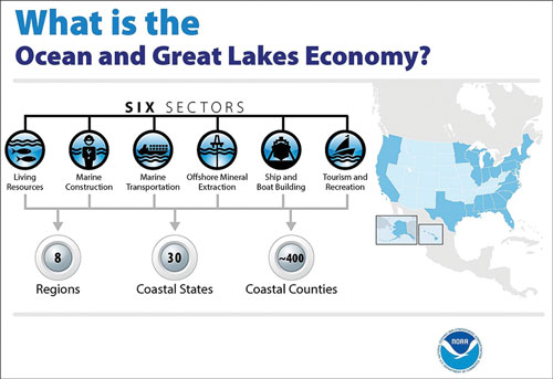
|
Main Report


