Why the framework is important and why you should participate.
Automating, sharing, and leveraging geographic data provide a continuum of benefits: Using a GIS provides many benefits, sharing geographic data provides additional benefits, and participating in the framework provides even more benefits. Each level of participation offers a new set of opportunities for reducing costs, improving operations, and facilitating decision making.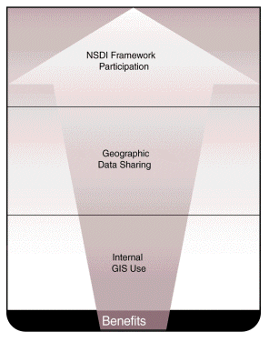
Increasing Benefits of Data Sharing Figure 2.1
Benefits of GIS
When an organization implements a GIS, it realizes many benefits. GIS software and hardware provide raw geographic data processing power, while the organization provides the data and procedures to which the processing power is applied. These components are combined into an operational GIS that provides many types of benefits. Converting from manual to automated geographic data handling can greatly improve the efficiency of many tasks, such as map creation, data access, and data manipulation and analysis. GIS tools and procedures can also greatly advance geographic data management.Data are a vital resource for organizations; a GIS can protect this investment and improve data quality by providing tools for validating, cross-checking, linking, and managing geographic data. One of the biggest benefits of a GIS is reduced duplication of data collection and maintenance efforts. Data can be collected only once and maintained by one group, while being accessible to many users who otherwise would have produced their own versions of the same data. Furthermore, sharing data improves many types of applications by streamlining data input tasks.
These technical benefits translate into visible operational benefits. A GIS enables an organization to improve efficiency, do more work with fewer resources, reduce costs, provide better service, and improve decision making. Thousands of organizations nationwide are implementing GISs for these reasons.
Benefits of Data Sharing
GIS benefits are increased by data sharing among organizations. For many organizations, building and using a GIS requires enormous amounts of current and accurate digital data. They can save significant time, money, and effort when they share the burden of data collection and maintenance. Base map conversion can cost millions of dollars, but when these data are gathered via partnerships, an organization's individual costs are reduced to only a portion of the total. The more partners there are, the more the savings and the greater the efficiency. Furthermore, the costs of data conversion are often so great that single organizations cannot afford to conduct such work. Sharing these costs enables them to implement GIS data and applications that would be impossible on their own. Sharing data can also improve data quality by increasing the number of individuals who find and correct errors.Savings realized on the production of common data can be used for other vital areas, such as application development. In addition, resources that would be used to collect repetitive data can be diverted into quality control, data management, and collection of other needed data.
Working together in a geographic area can also provide data coverage in a common form over a wider area. This aids cross-jurisdictional or cross-organizational analysis, decision making, and some types of operations. For example, adjoining jurisdictions may have a common interest in an environmental issue. A transit operator may serve a region, rather than stopping at county boundaries. Sharing geographic data that you have created also enables you to defray some of the costs of producing and maintaining those data. For example, if you have collected and are maintaining street data that is needed by other organizations, they may help you fund the ongoing data maintenance.
Benefits of the Framework
The framework represents a nationwide community for data sharing, and provides the benefits noted above as well as those specific to framework operation. It offers basic data, positional control, standards, guidelines, and communication. Participants can use it to obtain, contribute, and register data.The framework also provides a communication network of geographic data users nationwide. This environment supports participants who are building and using GISs. Common standards and guidelines provide GIS data developers with a template to use and expand, as needed, rather than developing their own from scratch.
As more organizations participate, the data pool widens, and more resource savings and operational benefits are realized. In addition, framework data can be used to address phenomena that do not adhere to jurisdictional boundaries or predefined regions that individual and consortia GISs address. Thus, all participants benefit as the area within which geographic analyses can be supported is broadened and boundaries are transcended.
Much of geographic data development nationwide and worldwide is based on developers' learning from the experiences of others. The framework represents the combined results of such experience and provides an environment for continued sharing.
Benefits of Participation
There are many intertwined benefits to producing and using framework data and participating in the framework's development. Specifically, framework participation enables you to
- save money by sharing the costs of data production and reducing duplicative efforts;
- develop applications faster and more easily by using existing data or data development standards;
- improve customer satisfaction through better data, faster response, and improved operations;
- provide better data for decision making;
- save development effort by using framework data standards and standardized data, guidelines, and tools;
- utilize data produced by others more quickly through the use of common formats and access methods;
- resolve problems created by conflicting data;
- redirect resources associated with duplicate data production and maintenance to your primary business activities;
- perform analyses, decision making, and operations in cross-jurisdictional areas;
- reduce the load from data requests by providing direct access to your data through the framework;
- attract clients who need data that are registered to the framework;
- expand market potential and program funding through recognition and credibility as a framework participant; and
- provide consolidated direction to vendors regarding needed
technical features.
Extra Benefits for Early Adopters
The sooner you begin to participate in the framework, the sooner you will realize the benefits. Every year delayed is a year of unnecessary expenditures and less efficient operations. And there are other reasons to join the framework early:
- Innovative organizations establish their positions as leaders in their fields.
- Early development of data, services, and expertise could give your organization a market advantage.
- Early participation could speed resolution of persistent problems caused by conflicting data.
- Early participation could position you to respond quickly when a need for data arises.
- Earlier participation means greater savings because benefits and savings accrue over a longer period.
- Simple steps that lead to framework participation also benefit your GIS development and operation. By following framework guidelines, you get immediate local GIS benefits.
- Early participants will have a bigger influence on how the framework is developed.
Costs of Framework Participation
Although framework participation is not without costs, they are more than offset by the benefits.Conforming to common standards has its costs. Those who have developed data according to their own standards may incur costs for converting to framework standards. Once initial costs are borne, however, access to framework data can save participants money. Those who have not yet developed standards and collected data can save money by using framework standards as a template from the start.
Some potential participants are concerned that framework standards may omit aspects that are unique and important to their organization; however, the framework consists of data and practices already used in many GIS and geographic data development efforts. The framework also provides a skeleton or base to which users can add unique elements.
Setting up partnerships for framework development also has costs. The time and effort required depend on the size and scope of the partnership. The benefits of any partnership must be weighed against the costs. Providing data to the framework may involve some costs for the producers, but opening access to their data also may bring opportunities to defray costs that would not be available otherwise.
Some organizations may think that it is better to wait until all aspects of the framework are settled and the framework is largely built. By sitting out the early stages of development, however, these organizations lose their voice in its direction. Furthermore, waiting until someone else creates the data you need is seldom a good strategy. If you produce data, you probably have a vested interest in having your data included as framework data -- it will be used as a base for other applications in your area. If you use data, you can add your requirements for consideration as the framework develops.
The idea is to start small by taking simple steps that will move you closer to framework participation. In the course of your normal GIS work you can become involved on a small scale and expand as time passes. (See chapter 5, "Getting Started.")