The USNG is an alpha-numeric reference system that overlays the UTM coordinate system. A USNG spatial address is broken down into three parts, the;
-
Grid Zone Designation; for a world-wide unique address.
-
100,000-meter Square Identification; for regional areas.
-
Grid Coordinates; for local areas.
This format allows a spatial address to be truncated (or another term might be abbreviated). For example, stationary letterhead for the Department of Interior might portray the address as:
Department of Interior
1849 C Street NW, Washington, DC 20006
USNG: 18SUJ22850705 (NAD 83)
A complete USNG spatial address provides a unique value and is necessary for use with GPS receivers and Geographical Information Systems (GIS). The USNG spatial address from the above stationary letterhead is for the building's centroid. On the other hand, a Department of Interior employee might tell someone coming to visit from the local area, "Our south visitor's entrance is located on 1849 C Street NW, at grid 22850694." Another spatial address might identify the north visitor's entrance, and another set might identify the loading ramp for delivery vehicles.
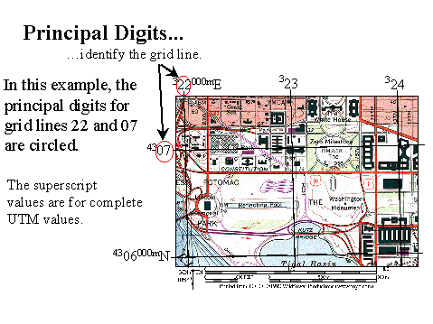
Local Area; reading grid coordinates. Grid coordinates are used to define a particular place within a local area (within a 100 by 100 kilometer area). Coordinates are written along the sides of a map designating specific grid lines. (These grid lines are based on UTM values.) The two larger numbers identify a grid line and are known as principal digits as depicted below.

To plot coordinate values, always read right, then up. Coordinates are always given as an even number of digits so you know where to separate the easting and northing coordinates. This allows you to abbreviate to the degree of precision you require within a local area. Grid coordinates are used to define point features, such as a neighborhood, soccer field, a particular house, or even a parking place. These require different levels of granularity. For example;
4 digits - 2306 - locates a point with a precision of 1,000-meters (a neighborhood size area).
6 digits - 234064 - locates a point with a precision of 100-meters (a soccer field size area).
8 digits - 23480647 - locates a point with a precision of 10-meters (the size of a modest home).
10 digits - 2348306479 - locates a point with a precision of 1-meter (within a parking spot).
In the following example, the Washington Monument is described as being located at grid 23480647 (think 2348 / 0647). Read right to grid line 23 (using the principal digits). Then count grid lines up to line 06. This intersection is known as grid 2306. This four digit value would give the location to within 1,000-meters. Measuring right in meters from line 23, we find the Washington Monument is another 480 meters east. The complete easing component is 23480. Measuring up in meters from grid line 06 the Monument is another 470-meters north. The complete northing component is 05470. We drop the 1-meter level values (shown as 0s in this case), and combining the easting and northing components, the grid coordinate is given as an eight digit value (to within 10-meters) as:
Grid: 23480647
Regional Area; 100,000-meter Square Identification.The USNG further divides the world into 100,000-meter squares and identifies these with two letter values. The illustration below depicts the Washington, DC area. In the spatial address for the Washington Monument (18SUJ23480647) you can see the monument falls within the 100,000-meter by 100,000-meter square designated UJ. (Note: The yellow and red square outlines a 100 km x 100 km sized local area surrounding Washington, DC.)
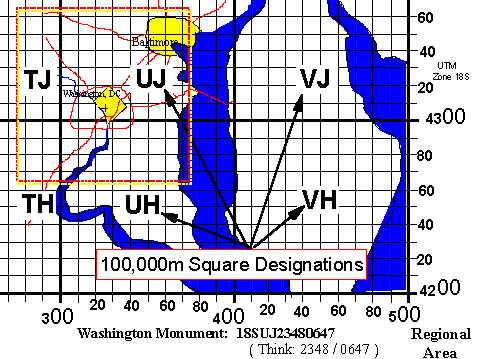
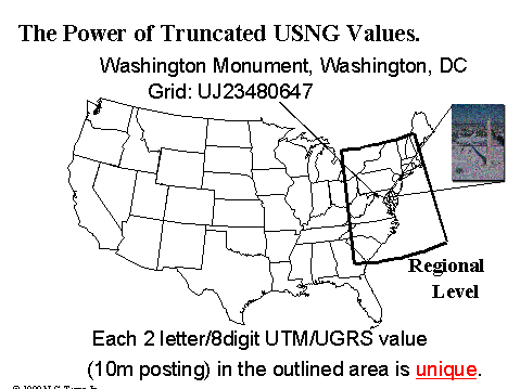
While the USNG is referred to as an alpha-numeric reference system for the UTM coordinate system, it is actually much more. The lettering scheme for the 100,000-meter Square Identification is designed such that any two-letter combination will not repeat itself but every 18° of longitude and a similar area in latitude. Thus any two letter prefix to a grid coordinate will provide a unique value within a very large area. In the case of the Washington Monument, at UJ23480647, it's location is uniquely designated within an area covering most of the east cost of the United States as depicted below.
World-Wide Unique Values; Grid Zone Designations. Working out from a local area, through regional areas, the last level of definition in a spatial address is the Grid Zone Designation. The world is divided into 60 UTM Zones, each 6° degrees of longitude wide. The numbering scheme for these begins at 180° longitude, and counts east. The conterminous US is covered by Zones 10 through 19. In a northing direction, the world is divided into 8° belts of latitude. The conterminous US for example is covered by belts R, S, T, and U. Thus the Washington, DC area falls within Grid Zone Designation 18S as depicted below. This prefix identifies a unique US National Grid spatial address for the Washington Monument over the entire planet. This complete, and unique spatial address is required for GPS receivers.

To review, we can see a complete US National Grid spatial address contains three parts as we drill down to a unique location,
18S UJ 23480647
-
Grid Zone Designation (i.e. 18S).
-
100,000-meter Square Identification (i.e. UJ ).
-
Grid coordinates of some even number of digits ranging from 2 to 10 (i.e. 23480647 In this case, eight digits identify a place of about the size of a modest home.). You always read right, then up when plotting coordinates.
A spatial address is customarily written as a single string of values. Note how the horizontal datum (NAD 83) has been included:
USNG: 18SUJ23480647 (NAD 83)